METAR & TAF KPHN
Current METAR
Observed 13:15Z
KPHN 271315Z AUTO 19004KT 7SM SCT024 BKN031 OVC042 23/20 A2984 RMK AO2
- Wind
- 190° @ 4 kt
- Visibility
- 7 SM
- Temp / Dew
- 23°C / 20°C
- Altimeter
- 29.84 inHg
- Clouds
- OVC
- Density alt
- 1,865 ft
- Ceiling
- 3,100 ft AGL
- Rules
- VFR
Airport info & contacts
Manager on record, flight service, ARTCC, attendance schedule and pattern altitude — published by the FAA and refreshed every 28 days.
Location
- From city
- 5 NM SW
- VFR sectional
- DETROIT
- ARTCC
- ZOB · CLEVELAND
- NOTAM facility
- PHN (NOTAM-D)
Airport manager
- Name
- CATHERINE FIORE
- Phone
- 810-364-6890
- Address
- 177 ASH DR, KIMBALL MI 48074-4403
Flight service · Hours
- FSS LAN
- LANSING1-800-WX-BRIEF
- Attendance
- 0800-1700
Frequencies
Tap any row to copy the frequency to your clipboard.
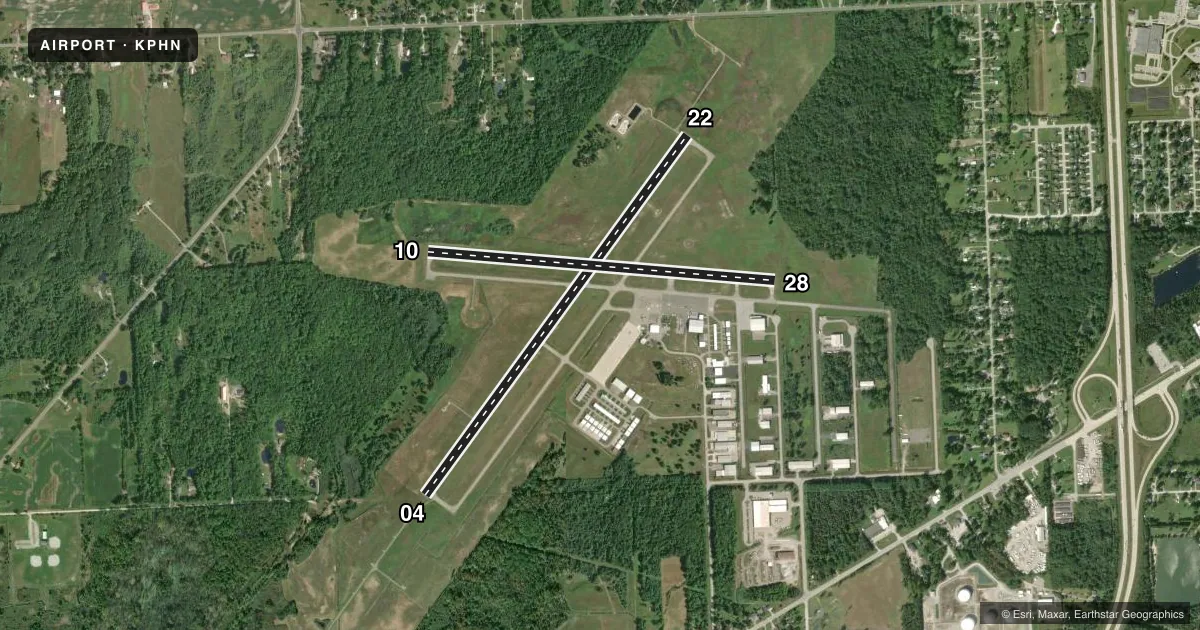
Runways & pattern
Full pagePattern entry · RWY 22
LEFT TRAFFIC| Runway | Heading (°M) | Length | Surface | Traffic |
|---|---|---|---|---|
| 04/22Favored | 29° / 209° | 5,104 ft | ASPH | Standard L |
| 10/28 | 88° / 268° | 4,000 ft | ASPH | Standard L |
Runway end performance
| End | TORA | TODA | ASDA | LDA | VGSI | Approach lights | Obstruction |
|---|---|---|---|---|---|---|---|
| 04 | — | — | — | — | PAPI 4-box left(3°) | MALSR | 49', tree, 592' from thr, 573' R of cntrln, slope 8 |
| 22 | — | — | — | — | PAPI 4-box left(3°) | — | 76', tree, 1870' from thr, 78' R of cntrln, slope 21 |
| 10 | — | — | — | — | PAPI 4-box left(3°) | — | 71', tree, 1386' from thr, 250' R of cntrln, slope 16 |
| 28 | — | — | — | — | PAPI 4-box left(3.5°) | — | 57', tree, 1173' from thr, 35' R of cntrln, slope 17 |
Declared distances in feet. TORA = takeoff run available, TODA = takeoff distance, ASDA = accelerate-stop, LDA = landing distance.
Airport sketch
Runways drawn to scale from FAA survey coordinates, rendered over satellite imagery. Not for navigation.
Approaches & charts
ILS · 1
Services on the field
Fuel grades, oxygen, maintenance, ramp storage and lighting — as declared to the FAA by the airport operator.
Fuel & services
- Fuel
- 100LLA+
- Oxygen (bottled)
- Not available
- Oxygen (bulk)
- Not available
- Airframe repair
- Major
- Power plant repair
- Major
Ramp & ground
- Transient storage
- Tie-down
- Hangar
- Landing fee
- Yes
- Customs
- Available
- Lighting schedule
- SEE RMK
- Beacon schedule
- SS-SR
- Beacon
- White / Green (civil land)(WG)
- Wind indicator
- Lighted
- Segmented circle
- Yes
Fuel & FBOs
Cheapest 100LL and Jet A on the field and nearby. Always confirm with the FBO before taxi.
Airport notes
Surface conditions, obstructions, local procedures, lighting outages and other notes published with each FAA cycle.
General notes
- DEER & LRG BIRDS ON & INVOF ARPT.
- TSATLC FLTS MUST NTFY US CUST AT 810-985-9541 ONE HR PRIOR TO ENTRY INTO THE US. NTFY US DEPT OF AGRICULTURE AT 810-985-6126 & AMGR 24 HRS PRIOR FOR DISPOSAL OF ACFT INTL TRASH.
- FOR CD CTC SELFRIDGE APCH AT 586-239-5706, WHEN APCH CLSD CTC CLEVELAND ARTCC AT 440-774-0224/0490.
Lighting notes
- ACTVT MALSR RWY 04; REIL RWY 22, 10, & 28; PAPI RWY 10 & 28; HIRL RWY 04/22; MIRL RWY 10/28 - CTAF. PAPI RWY 04 & 22 OPR CONSLY.
Other notes
- COML & CORPORATE LDG FEE WAIVED WITH FUEL PURCHASE.
- 1UNATNDD MAJOR HOLS.
VFR map & nearby airports
VFR sectional. Tap any ICAO chip to open that airport.
Key facts · KPHN
Answer card- ICAO
- KPHN
- Name
- ST CLAIR COUNTY INTL
- Location
- PORT HURON, MICHIGAN
- Elevation
- 650.1 ft MSL
- Traffic pattern altitude
- 1,650.1 ft MSL (1,000 AGL)
- Control tower
- Non-towered (use CTAF)
- Total runways
- 2
- Longest runway
- 04/22 · 5,104 ft
- Published ILS approaches
- 1
- Published frequencies
- 4
- Magnetic variation
- 7°
- Current flight rules
- VFR
- Current wind
- 190° at 4 kt
- Favored runway now
- RWY 22
St Clair County Intl Airport (KPHN) sits in Port Huron, Michigan. Field elevation is 650.1 ft MSL. The airport has two asphalt runways. Runway 04/22 is the longest at 5,104 ft. Runway 10/28 is 4,000 ft. There is no control tower. CTAF and UNICOM are both 123.05. One ILS approach is published for runway 04.
Pattern altitude is not published. Use 1,000 ft AGL for light piston traffic unless the current Chart Supplement says otherwise. The on-field FBO is St. Clair County International Airport. It carries 100LL and Jet A Prist. Call (810) 364-4187 for current services before arrival. Commercial and corporate landing fees are waived with fuel purchase. That matters if you are planning a quick stop.
Lighting is good to know here. MALSR is active on runway 04. REIL is available on 22, 10 and 28. PAPI is available on 10 and 28. Runways 04 and 22 have high intensity lighting. Runways 10 and 28 have medium intensity lighting that is controlled by CTAF. Deer and large birds are reported on and near the airport. If you are planning a night arrival or a first visit, brief the lighting setup. Stay alert for wildlife.