METAR & TAF D20
D20 does not publish a METAR.
Showing the nearest reporting station: KPHN (ST CLAIR COUNTY INTL) · 16.5 NM away. Conditions at D20 may differ.
METAR · KPHN
Observed 12:55Z
KPHN 241255Z AUTO 00000KT 10SM CLR 18/10 A3014 RMK AO2
- Wind
- 000° @ 0 kt
- Visibility
- 10 SM
- Temp / Dew
- 18°C / 10°C
- Altimeter
- 30.14 inHg
- Clouds
- CLR
- Density alt
- 1,098 ft
- Ceiling
- Unlimited
- Rules
- VFR
Airport info & contacts
Manager on record, flight service, ARTCC, attendance schedule and pattern altitude — published by the FAA and refreshed every 28 days.
Location
- From city
- 1 NM SE
- VFR sectional
- DETROIT
- ARTCC
- ZOB · CLEVELAND
- NOTAM facility
- LAN (NOTAM-D)
Airport manager
- Name
- JERRY L NORRIS
- Phone
- 810-387-2173
- Address
- 7381 BROCKWAY RD, YALE MI 48097-3801
Flight service · Hours
- FSS LAN
- LANSING1-800-WX-BRIEF
- Attendance
- IREG
Frequencies
Tap any row to copy the frequency to your clipboard.
Runways & pattern
Full pagePattern entry · RWY 09
LEFT TRAFFICRunway end performance
| End | TORA | TODA | ASDA | LDA | VGSI | Approach lights | Obstruction |
|---|---|---|---|---|---|---|---|
| 09 | — | — | — | — | — | — | 15', road, 30' from thr, 125' R of cntrln, slope 2 |
| 27 | — | — | — | — | — | — | 92', trees, 1246' from thr, 125' R of cntrln, slope 13 |
Declared distances in feet. TORA = takeoff run available, TODA = takeoff distance, ASDA = accelerate-stop, LDA = landing distance.
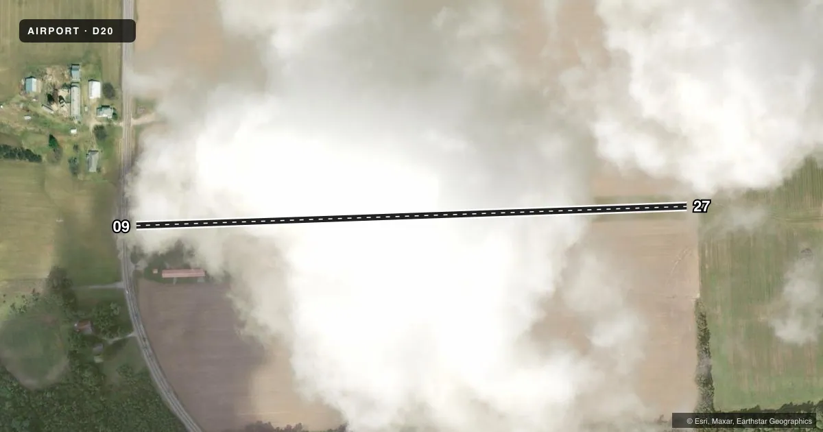
Airport sketch
Runways drawn to scale from FAA survey coordinates, rendered over satellite imagery. Not for navigation.
Approaches & charts
Services on the field
Fuel grades, oxygen, maintenance, ramp storage and lighting — as declared to the FAA by the airport operator.
Fuel & services
- Fuel
- Not available
- Oxygen (bottled)
- Not available
- Oxygen (bulk)
- Not available
- Airframe repair
- Not available
- Power plant repair
- Not available
Ramp & ground
- Transient storage
- Tie-down
- Landing fee
- No fee published
- Customs
- Not available
- Wind indicator
- Yes
- Segmented circle
- Yes
Fuel & FBOs
Cheapest 100LL and Jet A on the field and nearby. Always confirm with the FBO before taxi.
Airport notes
Surface conditions, obstructions, local procedures, lighting outages and other notes published with each FAA cycle.
General notes
- FOR CD CTC SELFRIDGE APCH AT 586-239-5706, WHEN APCH CLSD CTC CLEVELAND ARTCC AT 440-774-0224/0490.
- RWY 09 +25 FT PLINE, 345 FT DIST.
Approach & departure obstructions
- 09RWY 09/27 & DTHR MKD WITH 3 FT YELLOW CONES.
- 09APCH RATIO 20:1 TO DTHR.
- 27APCH RATIO 20:1 TO DTHR.
Other notes
- ESTABD BFR 1959.
- 09/27SOFT IN SPRING.
VFR map & nearby airports
VFR sectional. Tap any ICAO chip to open that airport.
Key facts · D20
Answer card- ICAO
- D20
- Name
- YALE
- Location
- YALE, MICHIGAN
- Elevation
- 815 ft MSL
- Traffic pattern altitude
- 1,815 ft MSL (1,000 AGL)
- Control tower
- Non-towered (use CTAF)
- Total runways
- 1
- Longest runway
- 09/27 · 2,300 ft
- Published ILS approaches
- 0
- Published frequencies
- 1
- Magnetic variation
- 6°
- Current flight rules
- VFR
- Current wind
- 000° at 0 kt
- Favored runway now
- –
YALE (D20) sits in Yale, Michigan. The field elevation is 815 ft MSL. It has one runway. Runway 09/27 is 2,300 ft of turf, which makes the field a short-field stop for light aircraft rather than a place to plan on long pavement margins. No control tower is published. CTAF is 122.9.
No ILS approaches are published here. The pattern altitude is not published, so use the standard 1,000 ft AGL unless the current FAA Chart Supplement says otherwise. That puts the traffic pattern at 1,815 ft MSL based on the listed field elevation. The runway headings are magnetic. Runway 09 is 88°. Runway 27 is 268°.
The published remarks matter here. The runway can be soft in spring. There is also a 25-foot power line 345 feet from runway 09. Both runway 09 and runway 27 have displaced thresholds marked with 3-foot yellow cones. The approach slope to each displaced threshold is listed at 20 to 1. For clearance delivery, contact Selfridge Approach at 586-239-5706. When approach is closed, contact Cleveland ARTCC at 440-774-0224 or 440-774-0490. No on-field FBOs are listed. Check with the airport operator or the FBO directly by phone for current services before you go.