METAR & TAF 55D
55D does not publish a METAR.
Showing the nearest reporting station: KPHN (ST CLAIR COUNTY INTL) · 25.7 NM away. Conditions at 55D may differ.
METAR · KPHN
Observed 00:15Z
KPHN 280015Z AUTO 00000KT 10SM CLR 26/17 A2969 RMK AO2
- Wind
- 000° @ 0 kt
- Visibility
- 10 SM
- Temp / Dew
- 26°C / 17°C
- Altimeter
- 29.69 inHg
- Clouds
- CLR
- Density alt
- 2,631 ft
- Ceiling
- Unlimited
- Rules
- VFR
Airport info & contacts
Manager on record, flight service, ARTCC, attendance schedule and pattern altitude — published by the FAA and refreshed every 28 days.
Location
- From city
- 2 NM S
- VFR sectional
- DETROIT
- ARTCC
- ZOB · CLEVELAND
- NOTAM facility
- LAN (NOTAM-D)
Airport manager
- Name
- WAYNE BURGESS
- Phone
- 810-346-3577
- Address
- 4155 GALBRAITH LINE RD, BROWN CITY MI 48416-8499
Flight service · Hours
- FSS LAN
- LANSING1-800-WX-BRIEF
- Attendance
- Unattended
Frequencies
Tap any row to copy the frequency to your clipboard.
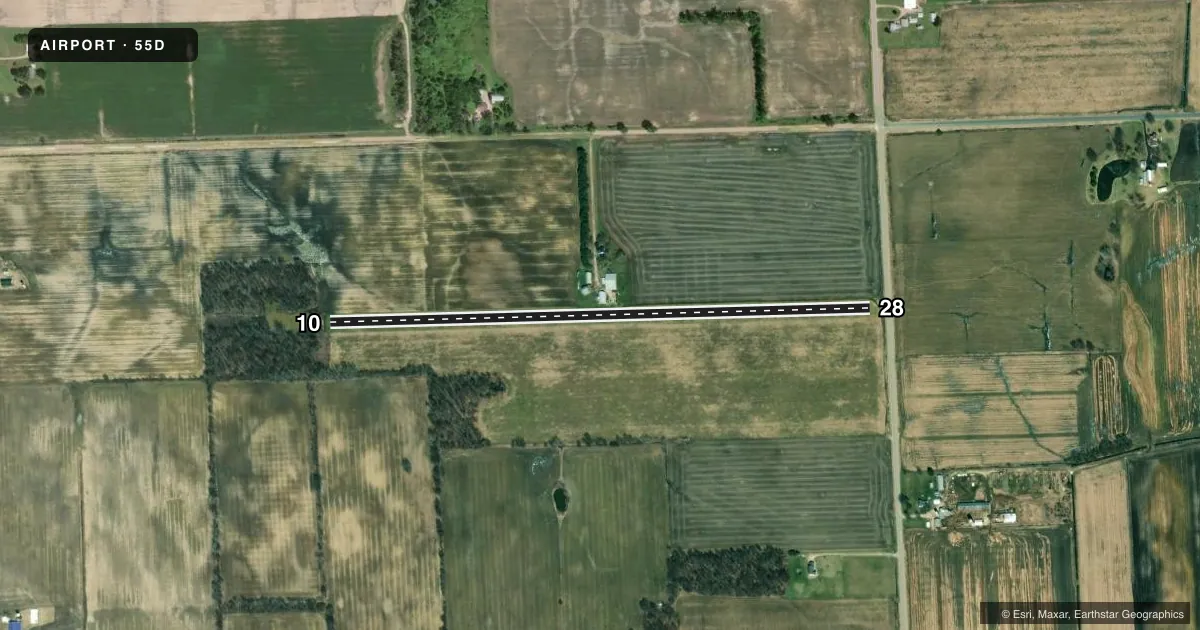
Runways & pattern
Full pagePattern entry · RWY 10
LEFT TRAFFICRunway end performance
| End | TORA | TODA | ASDA | LDA | VGSI | Approach lights | Obstruction |
|---|---|---|---|---|---|---|---|
| 10 | — | — | — | — | — | — | 70', trees, 75' from thr, 88' R of cntrln, slope 1 |
| 28 | — | — | — | — | — | — | 38', pline, 20' from thr, 125' R of cntrln, slope 0 |
Declared distances in feet. TORA = takeoff run available, TODA = takeoff distance, ASDA = accelerate-stop, LDA = landing distance.
Airport sketch
Runways drawn to scale from FAA survey coordinates, rendered over satellite imagery. Not for navigation.
Approaches & charts
Services on the field
Fuel grades, oxygen, maintenance, ramp storage and lighting — as declared to the FAA by the airport operator.
Fuel & services
- Fuel
- Not available
Ramp & ground
- Transient storage
- Not published
Fuel & FBOs
Cheapest 100LL and Jet A on the field and nearby. Always confirm with the FBO before taxi.
Airport notes
Surface conditions, obstructions, local procedures, lighting outages and other notes published with each FAA cycle.
General notes
- FOR CD CTC CLEVELAND ARTCC AT 440-774-0224/0490.
- RWY 10 DTHR 1593 FT, EXTDS BYD RWY MIDPT.
- DEER, BIRDS, & WILDLIFE INVOF ARPT.
- OPPOSITE RWY END NOT VSB FM THR.
Approach & departure obstructions
- 10RWY & DTHR MKD WITH 3 FT YELLOW CONES.
- 28RWY & DTHR MKD WITH 3 FT YELLOW CONES.
- 10APCH RATIO 20:1 TO DTHR.
- 28CTLG OBSTN EXCEEDS A 45 DEG SLP. APCH RATIO 20:1 TO DTHR.
VFR map & nearby airports
VFR sectional. Tap any ICAO chip to open that airport.
Key facts · 55D
Answer card- ICAO
- 55D
- Name
- BURGESS FLD
- Location
- BROWN CITY, MICHIGAN
- Elevation
- 827.3 ft MSL
- Traffic pattern altitude
- 1,827.3 ft MSL (1,000 AGL)
- Control tower
- Non-towered (use CTAF)
- Total runways
- 1
- Longest runway
- 10/28 · 3,090 ft
- Published ILS approaches
- 0
- Published frequencies
- 1
- Magnetic variation
- –
- Current flight rules
- VFR
- Current wind
- 000° at 0 kt
- Favored runway now
- –
Burgess Fld sits near Brown City, Michigan. Field elevation is 827.3 ft MSL. The airport has one runway. Runway 10/28 is 3,090 ft long and turf. No tower is published here, so use CTAF 122.9 for traffic calls. No ILS approaches are published. Pattern altitude is not published, so plan on the standard 1,000 ft AGL for light piston operations unless the current Chart Supplement says otherwise.
This is a small field with some runway-specific details that matter. Runway 10 has a displaced threshold of 1,593 ft. The opposite end is not visible from the threshold. Published remarks also note a 20 to 1 approach ratio to the displaced threshold on both ends. There are 3 foot yellow cones at each runway end. Deer and large birds are reported on and near the airport, so keep a sharp scan on arrival and departure.
There are no on-field FBOs listed in the facts. If you need fuel or local services, contact the airport operator directly or call the field on CTAF for current availability. For clearance delivery, the published remark points pilots to Cleveland ARTCC at 440-774-0224 or 440-774-0490. Check the current Chart Supplement for any updated operating notes before you go.