METAR & TAF Y83
Y83 does not publish a METAR.
Showing the nearest reporting station: KBAX (HURON COUNTY MEML) · 20.5 NM away. Conditions at Y83 may differ.
METAR · KBAX
Observed 00:35Z
KBAX 280035Z AUTO 28007KT 10SM CLR 25/19 A2968 RMK AO2
- Wind
- 280° @ 7 kt
- Visibility
- 10 SM
- Temp / Dew
- 25°C / 19°C
- Altimeter
- 29.68 inHg
- Clouds
- CLR
- Density alt
- 2,461 ft
- Ceiling
- Unlimited
- Rules
- VFR
Airport info & contacts
Manager on record, flight service, ARTCC, attendance schedule and pattern altitude — published by the FAA and refreshed every 28 days.
Location
- From city
- 3 NM N
- VFR sectional
- DETROIT
- ARTCC
- ZOB · CLEVELAND
- NOTAM facility
- LAN (NOTAM-D)
Airport manager
- Name
- DON JOHNSTON
- Phone
- 810-414-3009
- Address
- CITY HALL, 26 W SPEAKER ST, SANDUSKY MI 48471-1299
Flight service · Hours
- FSS LAN
- LANSING1-800-WX-BRIEF
- Attendance
- MON-FRI · 0900-1630
- SAT-SUN · ON CALL
Frequencies
Tap any row to copy the frequency to your clipboard.
Runways & pattern
Full pagePattern entry · RWY 28
LEFT TRAFFIC| Runway | Heading (°M) | Length | Surface | Traffic |
|---|---|---|---|---|
| 10/28Favored | 81° / 261° | 3,499 ft | ASPH | Standard L |
| 18/36 | 171° / 351° | 2,271 ft | TURF | Standard L |
Runway end performance
| End | TORA | TODA | ASDA | LDA | VGSI | Approach lights | Obstruction |
|---|---|---|---|---|---|---|---|
| 10 | — | — | — | — | PAPI 2-box left(3°) | — | — |
| 28 | — | — | — | — | PAPI 2-box left(3°) | — | — |
| 36 | — | — | — | — | — | — | 17', road, 58' from thr, 125' R of cntrln, slope 3 |
Declared distances in feet. TORA = takeoff run available, TODA = takeoff distance, ASDA = accelerate-stop, LDA = landing distance.
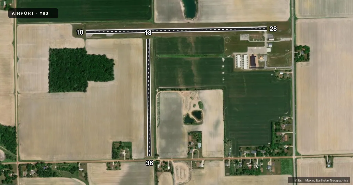
Airport sketch
Runways drawn to scale from FAA survey coordinates, rendered over satellite imagery. Not for navigation.
Approaches & charts
Services on the field
Fuel grades, oxygen, maintenance, ramp storage and lighting — as declared to the FAA by the airport operator.
Fuel & services
- Fuel
- 100LL
- Oxygen (bottled)
- Not available
- Oxygen (bulk)
- Not available
- Airframe repair
- Major
- Power plant repair
- Major
Ramp & ground
- Transient storage
- Tie-down
- Hangar
- Landing fee
- No fee published
- Customs
- Not available
- Lighting schedule
- SEE RMK
- Beacon schedule
- SS-SR
- Beacon
- White / Green (civil land)(WG)
- Wind indicator
- Lighted
- Segmented circle
- Yes
Fuel & FBOs
Cheapest 100LL and Jet A on the field and nearby. Always confirm with the FBO before taxi.
Airport notes
Surface conditions, obstructions, local procedures, lighting outages and other notes published with each FAA cycle.
General notes
- +3 FT EMBANKMENT, 50 FT FM RWY 36 THR; -10 FT DITCH, 100 FT EAST OF RWY 18/36.
- DEER & LRG BIRDS ON & INVOF ARPT.
- FOR CD CTC CLEVELAND ARTCC AT 440-774-0224/0490.
- FOR AFT HRS ACES TO TRML BLDG CALL AMGR.
Lighting notes
- ACTVT MIRL RWY 10/28 - CTAF.
Approach & departure obstructions
- 183 FT YELLOW CONES.
- 363 FT YELLOW CONES.
- 36APCH RATIO 6:1 TO DTHR OVR 63 FT TREE, 380 FT DIST, 150 FT R.
Other notes
- 2FOR SVC AFT HRS CALL AMGR.
VFR map & nearby airports
VFR sectional. Tap any ICAO chip to open that airport.
Key facts · Y83
Answer card- ICAO
- Y83
- Name
- SANDUSKY CITY
- Location
- SANDUSKY, MICHIGAN
- Elevation
- 776.9 ft MSL
- Traffic pattern altitude
- 1,776.9 ft MSL (1,000 AGL)
- Control tower
- Non-towered (use CTAF)
- Total runways
- 2
- Longest runway
- 10/28 · 3,499 ft
- Published ILS approaches
- 0
- Published frequencies
- 2
- Magnetic variation
- 8°
- Current flight rules
- VFR
- Current wind
- 280° at 7 kt
- Favored runway now
- RWY 28
Sandusky City Airport is in Sandusky, Michigan. The field elevation is 776.9 ft MSL. It has two runways. The longest is runway 10/28 at 3,499 ft. Runway 18/36 is turf and measures 2,271 ft. There is no control tower. CTAF and UNICOM are both 122.8.
No ILS approaches are published here. The pattern altitude is not published, so use the standard 1,000 ft AGL for light piston traffic unless the current FAA Chart Supplement says otherwise. The on-field FBO is Sandusky City Airport. It carries AVGAS 100LL. Call (810) 414-3009 for current service details.
A few local items matter on first arrival. Deer and large birds are reported on and near the airport. Runway 10/28 has medium intensity lights that are activated by CTAF. There is a 3 ft embankment near runway 36 and a 10 ft ditch east of runway 18/36. Runway 18 and runway 36 are marked with 3 ft yellow cones. The approach to runway 36 also has a tree close in on the right side, so plan your descent and landing sight picture carefully. For clearance delivery, contact Cleveland ARTCC. For after-hours access or service, call the airport manager.