METAR & TAF E53
E53 does not publish a METAR.
Showing the nearest reporting station: KBAX (HURON COUNTY MEML) · 4.8 NM away. Conditions at E53 may differ.
METAR · KBAX
Observed 19:35Z
KBAX 271935Z AUTO 16009KT 10SM CLR 24/21 A2972 RMK AO2
- Wind
- 160° @ 9 kt
- Visibility
- 10 SM
- Temp / Dew
- 24°C / 21°C
- Altimeter
- 29.72 inHg
- Clouds
- CLR
- Density alt
- 2,227 ft
- Ceiling
- Unlimited
- Rules
- VFR
Airport info & contacts
Manager on record, flight service, ARTCC, attendance schedule and pattern altitude — published by the FAA and refreshed every 28 days.
Location
- From city
- 4 NM NW
- VFR sectional
- DETROIT
- ARTCC
- ZMP · MINNEAPOLIS
- NOTAM facility
- LAN (NOTAM-D)
Airport manager
- Name
- ALAN ENGLER
- Phone
- 989-269-8815
- Address
- 1815 N THOMAS RD, BAD AXE MI 48413-8431
Flight service · Hours
- FSS LAN
- LANSING1-800-WX-BRIEF
- Attendance
- IREG
Frequencies
Tap any row to copy the frequency to your clipboard.
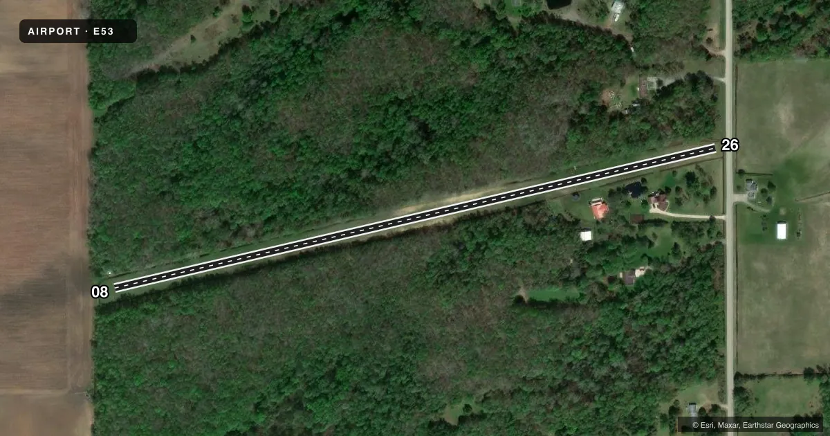
Runways & pattern
Full pagePattern entry · RWY 08
LEFT TRAFFICRunway end performance
| End | TORA | TODA | ASDA | LDA | VGSI | Approach lights | Obstruction |
|---|---|---|---|---|---|---|---|
| 08 | — | — | — | — | — | — | 75', trees, 0' from thr, 56' R of cntrln, slope 0 |
| 26 | — | — | — | — | — | — | 59', trees, 0' from thr, 56' R of cntrln, slope 0 |
Declared distances in feet. TORA = takeoff run available, TODA = takeoff distance, ASDA = accelerate-stop, LDA = landing distance.
Airport sketch
Runways drawn to scale from FAA survey coordinates, rendered over satellite imagery. Not for navigation.
Approaches & charts
Services on the field
Fuel grades, oxygen, maintenance, ramp storage and lighting — as declared to the FAA by the airport operator.
Fuel & services
- Fuel
- Not available
- Airframe repair
- Minor
- Power plant repair
- Minor
Ramp & ground
- Transient storage
- Tie-down
- Wind indicator
- Yes
Fuel & FBOs
Cheapest 100LL and Jet A on the field and nearby. Always confirm with the FBO before taxi.
Airport notes
Surface conditions, obstructions, local procedures, lighting outages and other notes published with each FAA cycle.
General notes
- SNOW REMOVAL IREG FOR INFO CTC AMGR.
- +8 FT SEASONAL CORN CROP WEST OF RWY.
- -2 FT DITCH 45 FT EAST OF RWY.
- WIND TURBINE FARM 2.0 NM WEST OF ARPT.
- +5 FT GATE 40 FT EAST OF RWY.
- FOR CD CTC MINNEAPOLIS ARTCC AT 651-463-5588.
- DEER & LRG BIRDS ON & INVOF ARPT.
Approach & departure obstructions
- 08RWY 07/25 & DTHR MKD WITH 3 FT YELLOW CONES.
- 08CTLNG OBSTN EXCEEDS A 45 DEG SLP.
- 26CTLNG OBSTN EXCEEDS A 45 DEG SLP. RWY 26 APCH RATIO 0:1 TO DTHR, + 68 FT TREE, 0 FT DIST, 80 FT L.
Other notes
- MAN-MADE OR NATURAL OBJECTS EXIST WI THE ASP NEEDED TO ENSURE SAFETY IN THE TKOF/LDG OF ACFT.
- OWNERRESIDES ON ARPT PREMISES.
VFR map & nearby airports
VFR sectional. Tap any ICAO chip to open that airport.
Key facts · E53
Answer card- ICAO
- E53
- Name
- ENGLER FLD
- Location
- BAD AXE, MICHIGAN
- Elevation
- 725 ft MSL
- Traffic pattern altitude
- 1,725 ft MSL (1,000 AGL)
- Control tower
- Non-towered (use CTAF)
- Total runways
- 1
- Longest runway
- 08/26 · 2,523 ft
- Published ILS approaches
- 0
- Published frequencies
- 1
- Magnetic variation
- 7°
- Current flight rules
- VFR
- Current wind
- 160° at 9 kt
- Favored runway now
- RWY 08
Engler Fld sits near Bad Axe, Michigan. The field elevation is 725 ft MSL. It has one runway. Runway 08/26 is 2,523 ft long and turf. There is no control tower. CTAF is 122.9. No ILS approaches are published here.
Pattern altitude is not published. For light piston work, use the standard 1,000 ft AGL pattern unless the current Chart Supplement says otherwise. That puts the pattern at about 1,725 ft MSL based on the field elevation. Verify before you fly. The runway headings are 77° and 257° magnetic. Magnetic variation is 7°.
There are no on-field FBOs listed. Plan to confirm services with the airport operator or by phone before arrival. Published remarks call out deer and large birds in the area. They also note a ditch east of the runway, a gate east of the runway, a seasonal corn crop west of the runway and a wind turbine farm 2.0 NM west of the airport. Snow removal is irregular. The field also has obstruction concerns near both runway ends. If you are new to E53, treat it as a small turf strip with limited margin. Check the current Chart Supplement for any operational changes before you go.