METAR & TAF KCFS
Current METAR
Observed 17:15Z
KCFS 271715Z AUTO 23007KT 10SM CLR 28/22 A2972 RMK AO2 PRESFR
- Wind
- 230° @ 7 kt
- Visibility
- 10 SM
- Temp / Dew
- 28°C / 22°C
- Altimeter
- 29.72 inHg
- Clouds
- CLR
- Density alt
- 2,681 ft
- Ceiling
- Unlimited
- Rules
- VFR
Airport info & contacts
Manager on record, flight service, ARTCC, attendance schedule and pattern altitude — published by the FAA and refreshed every 28 days.
Location
- From city
- 3 NM SW
- VFR sectional
- DETROIT
- ARTCC
- ZOB · CLEVELAND
- NOTAM facility
- CFS (NOTAM-D)
Airport manager
- Name
- JOE GREENE
- Phone
- 989-670-2441
- Address
- 1750 SPEIRS RD, CARO MI 48723-8211
Flight service · Hours
- FSS LAN
- LANSING1-800-WX-BRIEF
- Attendance
- IREG
Frequencies
Tap any row to copy the frequency to your clipboard.
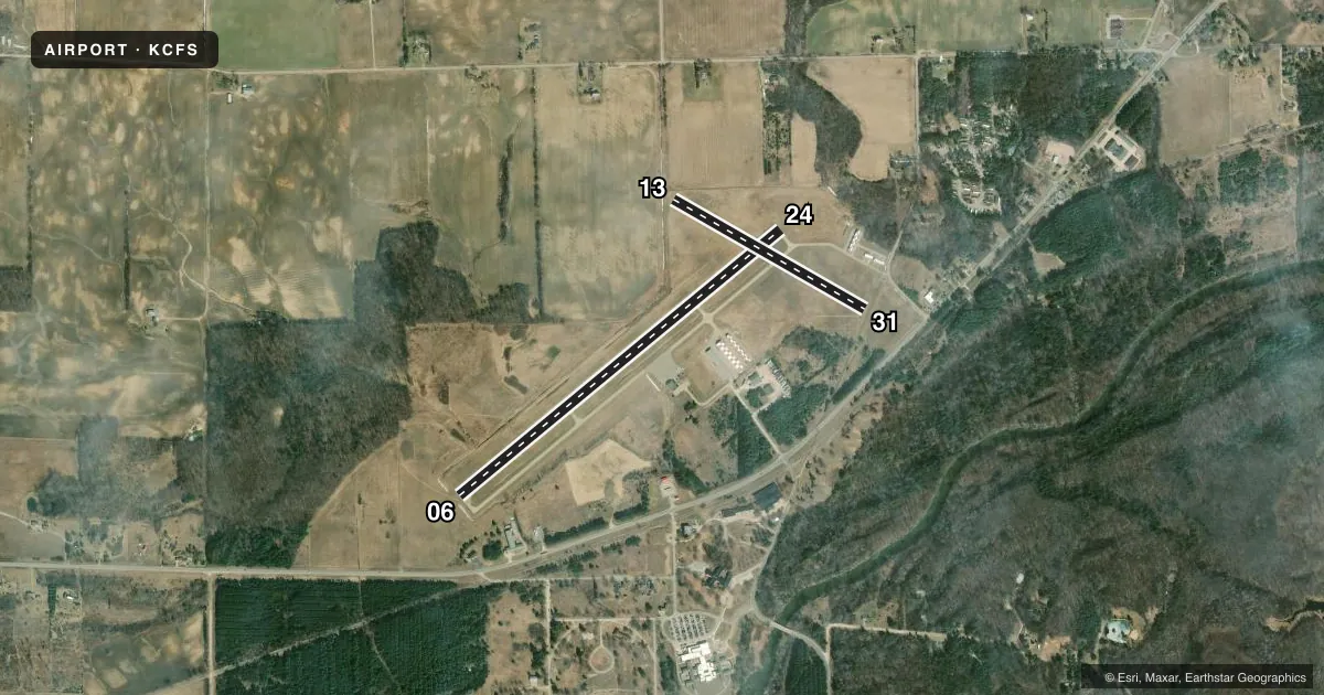
Runways & pattern
Full pagePattern entry · RWY 24
LEFT TRAFFIC| Runway | Heading (°M) | Length | Surface | Traffic |
|---|---|---|---|---|
| 06/24Favored | 42° / 222° | 4,302 ft | ASPH | Standard L |
| 13/31 | 112° / 292° | 2,277 ft | TURF | Standard L |
Runway end performance
| End | TORA | TODA | ASDA | LDA | VGSI | Approach lights | Obstruction |
|---|---|---|---|---|---|---|---|
| 06 | — | — | — | — | PAPI 4-box left(3°) | — | 60', tree, 1215' from thr, 265' R of cntrln, slope 16 |
| 24 | — | — | — | — | PAPI 4-box left(3.5°) | — | 48', tree, 793' from thr, 300' R of cntrln, slope 12 |
| 13 | — | — | — | — | — | — | 1', brush, 0' from thr, 125' R of cntrln, slope 0 |
| 31 | — | — | — | — | — | — | 78', tree, 1054' from thr, 40' R of cntrln, slope 13 |
Declared distances in feet. TORA = takeoff run available, TODA = takeoff distance, ASDA = accelerate-stop, LDA = landing distance.
Airport sketch
Runways drawn to scale from FAA survey coordinates, rendered over satellite imagery. Not for navigation.
Approaches & charts
Services on the field
Fuel grades, oxygen, maintenance, ramp storage and lighting — as declared to the FAA by the airport operator.
Fuel & services
- Fuel
- 100LLA+
- Oxygen (bottled)
- Not available
- Oxygen (bulk)
- Not available
- Airframe repair
- Major
- Power plant repair
- Major
Ramp & ground
- Transient storage
- Tie-down
- Hangar
- Landing fee
- No fee published
- Customs
- Not available
- Lighting schedule
- SEE RMK
- Beacon schedule
- SS-SR
- Beacon
- White / Green (civil land)(WG)
- Wind indicator
- Lighted
- Segmented circle
- Yes
Fuel & FBOs
Cheapest 100LL and Jet A on the field and nearby. Always confirm with the FBO before taxi.
Airport notes
Surface conditions, obstructions, local procedures, lighting outages and other notes published with each FAA cycle.
General notes
- DEER & LRG BIRDS ON & INVOF ARPT.
- RC ACFT OPS S OF RWY INT.
- FOR CD CTC GREAT LAKES APCH AT 269-459-3345, WHEN APCH CLSD CTC CLEVELAND ARTCC AT 440-774-0224/0490.
Lighting notes
- ACTVT PAPI RWY 06 & 24; MIRL RWY 06/24 - CTAF. PAPI RWY 06 & 24 OPR CONSLY DAWN-DUSK.
Approach & departure obstructions
- 133 FT YELLOW CONES.
- 06PAPI UNUSBL BYD 9 DEGS LEFT OF CNTRLN.
- 13CTLNG OBSTN EXCEEDS A 45 DEG SLP.
- 31APCH RATIO 20:1 TO DTHR.
VFR map & nearby airports
VFR sectional. Tap any ICAO chip to open that airport.
Key facts · KCFS
Answer card- ICAO
- KCFS
- Name
- TUSCOLA AREA
- Location
- CARO, MICHIGAN
- Elevation
- 704.3 ft MSL
- Traffic pattern altitude
- 1,704.3 ft MSL (1,000 AGL)
- Control tower
- Non-towered (use CTAF)
- Total runways
- 2
- Longest runway
- 06/24 · 4,302 ft
- Published ILS approaches
- 0
- Published frequencies
- 4
- Magnetic variation
- 8°
- Current flight rules
- VFR
- Current wind
- 230° at 7 kt
- Favored runway now
- RWY 24
Tuscola Area Airport (KCFS) sits near Caro, Michigan. Field elevation is 704.3 ft MSL. The airport has 2 runways. The longest is 4,302 ft on runway 06/24. Runway 13/31 is turf and measures 2,277 ft. There is no control tower. No ILS approaches are published.
Pattern altitude is not published. Use the standard 1,000 ft AGL pattern for light piston traffic unless the current FAA Chart Supplement says otherwise. That puts the pattern at about 1,704 ft MSL based on the field elevation. The on-field FBO is Tuscola Area Airport. It carries AVGAS 100LL and Jet A with Prist. Call (989) 233-4124 for current service details.
A few operational notes matter here. Deer and large birds are reported on and near the airport. Runway 13 has a ceiling obstruction that exceeds a 45 degree slope. Runway 31 has a 20 to 1 approach ratio to the displaced threshold. Runway 06 has a PAPI limitation left of centerline. The PAPI and medium intensity lights for 06/24 are activated by CTAF. The PAPI on 06 and 24 runs continuously from dawn to dusk. Rotocraft operations are south of the runway intersection. For clearance delivery, contact Great Lakes Approach. If approach is closed, use Cleveland ARTCC. Check the current FAA Chart Supplement before flight for any updated procedures or restrictions.