METAR & TAF 60D
60D does not publish a METAR.
Showing the nearest reporting station: KCFS (TUSCOLA AREA) · 8.3 NM away. Conditions at 60D may differ.
METAR · KCFS
Observed 15:15Z
KCFS 271515Z AUTO 23015G21KT 10SM BKN014 BKN018 BKN024 27/23 A2976 RMK AO2
- Wind
- 230° @ 15G21 kt
- Visibility
- 10 SM
- Temp / Dew
- 27°C / 23°C
- Altimeter
- 29.76 inHg
- Clouds
- BKN
- Density alt
- 2,457 ft
- Ceiling
- 1,400 ft AGL
- Rules
- MVFR
Airport info & contacts
Manager on record, flight service, ARTCC, attendance schedule and pattern altitude — published by the FAA and refreshed every 28 days.
Location
- From city
- 3 NM ESE
- VFR sectional
- DETROIT
- ARTCC
- ZOB · CLEVELAND
- NOTAM facility
- LAN (NOTAM-D)
Airport manager
- Name
- DAN BAUER
- Phone
- 989-737-6415
- Address
- 2457 S BRADFORD RD, REESE MI 48757-9211
Flight service · Hours
- FSS LAN
- LANSING1-800-WX-BRIEF
- Attendance
- Unattended
Frequencies
Tap any row to copy the frequency to your clipboard.
Runways & pattern
Full pagePattern entry · RWY 28
LEFT TRAFFICRunway end performance
| End | TORA | TODA | ASDA | LDA | VGSI | Approach lights | Obstruction |
|---|---|---|---|---|---|---|---|
| 10 | — | — | — | — | — | — | 19', bldg, 0' from thr, 51' R of cntrln, slope 0 |
Declared distances in feet. TORA = takeoff run available, TODA = takeoff distance, ASDA = accelerate-stop, LDA = landing distance.
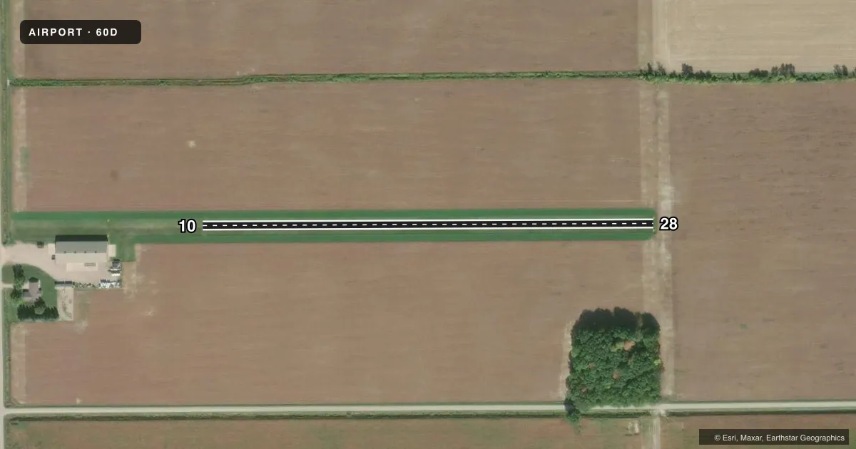
Airport sketch
Runways drawn to scale from FAA survey coordinates, rendered over satellite imagery. Not for navigation.
Approaches & charts
Services on the field
Fuel grades, oxygen, maintenance, ramp storage and lighting — as declared to the FAA by the airport operator.
Fuel & services
- Fuel
- Not available
Ramp & ground
- Transient storage
- Not published
Fuel & FBOs
Cheapest 100LL and Jet A on the field and nearby. Always confirm with the FBO before taxi.
Airport notes
Surface conditions, obstructions, local procedures, lighting outages and other notes published with each FAA cycle.
General notes
- FOR CD CTC GREAT LAKES APCH AT 269-459-3345, WHEN APCH CLSD CTC CLEVELAND ARTCC AT 440-774-0224/0490.
- DEER & LRG BIRDS ON & INVOF ARPT.
Approach & departure obstructions
- 10RWY DEFINED BY MOWING; THR MKD WITH 3 FT YELLOW CONES.
- 28RWY DEFINED BY MOWING; THR MKD WITH 3 FT YELLOW CONES.
- 10CTLG OBSTN EXCEEDS A 45 DEG SLP. APCH RATIO 20:1 TO DTHR.
VFR map & nearby airports
VFR sectional. Tap any ICAO chip to open that airport.
Key facts · 60D
Answer card- ICAO
- 60D
- Name
- BAUER FLD
- Location
- REESE, MICHIGAN
- Elevation
- 660 ft MSL
- Traffic pattern altitude
- 1,660 ft MSL (1,000 AGL)
- Control tower
- Non-towered (use CTAF)
- Total runways
- 1
- Longest runway
- 10/28 · 1,800 ft
- Published ILS approaches
- 0
- Published frequencies
- 1
- Magnetic variation
- –
- Current flight rules
- MVFR
- Current wind
- 230° at 15 kt
- Favored runway now
- RWY 28
Bauer Fld sits in Reese, Michigan. Field elevation is 660 ft MSL. It has one runway. Runway 10/28 is 1,800 ft of turf, which makes this a short-field stop for light aircraft. The airport is non-towered. CTAF is 122.9.
No ILS approaches are published here. Pattern altitude is not published in the facts. Use the current Chart Supplement or call the airport operator before you go if you need the local pattern entry details. The published remarks matter here. Runway 10 and Runway 28 are both defined by mowing. Each threshold is marked with 3-foot yellow cones. There is also a cataloged obstruction near the Runway 10 end. The published note says the approach surface exceeds a 45 degree slope, with a 20 to 1 approach ratio to the displaced threshold. Deer and large birds are also reported on and near the airport.
No on-field FBOs are listed in the facts. Contact the airport operator directly or call the field on CTAF for current services before arrival. If you need clearance delivery for an IFR flight, the published remark says to contact Great Lakes Approach at 269-459-3345. When approach is closed, contact Cleveland ARTCC at 440-774-0224 or 440-774-0490.