METAR & TAF 3DA
3DA does not publish a METAR.
Showing the nearest reporting station: KFNT (BISHOP INTL) · 6.1 NM away. Conditions at 3DA may differ.
METAR · KFNT
Observed 16:53Z
KFNT 271653Z 25011KT 10SM CLR 30/19 A2977 RMK AO2 SLP074 T03000194
- Wind
- 250° @ 11 kt
- Visibility
- 10 SM
- Temp / Dew
- 30°C / 19°C
- Altimeter
- 29.77 inHg
- Clouds
- CLR
- Density alt
- 2,895 ft
- Ceiling
- Unlimited
- Rules
- VFR
Airport info & contacts
Manager on record, flight service, ARTCC, attendance schedule and pattern altitude — published by the FAA and refreshed every 28 days.
Location
- From city
- 2 NM E
- VFR sectional
- DETROIT
- ARTCC
- ZOB · CLEVELAND
- NOTAM facility
- LAN (NOTAM-D)
Airport manager
- Name
- BILL CAMPEAU
- Phone
- 810-736-7231
- Address
- PO BOX 310693, FLINT MI 48531-0693
Flight service · Hours
- FSS LAN
- LANSING1-800-WX-BRIEF
- Attendance
- IREG · IREG
Frequencies
Tap any row to copy the frequency to your clipboard.
Runways & pattern
Full pagePattern entry · RWY 27
LEFT TRAFFIC| Runway | Heading (°M) | Length | Surface | Traffic |
|---|---|---|---|---|
| 18/36 | 173° / 353° | 2,510 ft | ASPH | Standard L |
| 09/27Favored | 84° / 264° | 1,633 ft | TURF | Standard L |
Runway end performance
| End | TORA | TODA | ASDA | LDA | VGSI | Approach lights | Obstruction |
|---|---|---|---|---|---|---|---|
| 18 | — | — | — | — | — | — | 43', tree, 221' from thr, 125' R of cntrln, slope 0 |
| 36 | — | — | — | — | — | — | 57', trees, 324' from thr, 50' R of cntrln, slope 2 |
| 09 | — | — | — | — | — | — | 34', tree, 423' from thr, 70' R of cntrln, slope 12 |
| 27 | — | — | — | — | — | — | 22', road, 48' from thr, 125' R of cntrln, slope 2 |
Declared distances in feet. TORA = takeoff run available, TODA = takeoff distance, ASDA = accelerate-stop, LDA = landing distance.
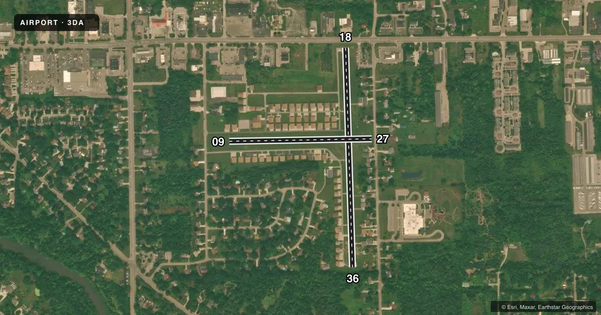
Airport sketch
Runways drawn to scale from FAA survey coordinates, rendered over satellite imagery. Not for navigation.
Approaches & charts
Services on the field
Fuel grades, oxygen, maintenance, ramp storage and lighting — as declared to the FAA by the airport operator.
Fuel & services
- Fuel
- 100LL
- Oxygen (bottled)
- Not available
- Oxygen (bulk)
- Not available
Ramp & ground
- Transient storage
- Tie-down
- Landing fee
- No fee published
- Customs
- Not available
- Lighting schedule
- SEE RMK
- Beacon schedule
- SS-SR
- Beacon
- White / Green (civil land)(WG)
- Wind indicator
- Yes
Fuel & FBOs
Cheapest 100LL and Jet A on the field and nearby. Always confirm with the FBO before taxi.
Airport notes
Surface conditions, obstructions, local procedures, lighting outages and other notes published with each FAA cycle.
General notes
- FOR CD CTC GREAT LAKES APCH AT 269-459-3345, WHEN APCH CLSD CTC CLEVELAND ARTCC AT 440-774-0224/0490.
- DEER & LRG BIRDS ON & INVOF ARPT.
Lighting notes
- ACTVT LIRL RWY 18/36 - CTAF.
Fuel notes
- 100LLFUEL AVBL VIA CREDIT CARD.
Runway surface & condition
- 09/27CLSD OCT-MAR.
Approach & departure obstructions
- 18+32 FT TREES, 131 FT DIST; PLINE & ROAD.
- 093 FT YELLOW CONES.
- 27RWY & DTHR MKD WITH 3 FT YELLOW CONES.
- 18CTLG OBSTN EXCEEDS A 45 DEG SLP. APCH RATIO 20:1 TO DTHR.
- 27APCH RATIO 15:1 TO DTHR OVR 49 FT TREE, 770 FT DIST, 42 FT R.
- 36APCH RATIO 18:1 TO DTHR OVR +71 FT TREE, 1287 FT DIST, 0 FT B.
Other notes
- ESTABD BFR 1959.
VFR map & nearby airports
VFR sectional. Tap any ICAO chip to open that airport.
Key facts · 3DA
Answer card- ICAO
- 3DA
- Name
- DALTON
- Location
- FLUSHING, MICHIGAN
- Elevation
- 733 ft MSL
- Traffic pattern altitude
- 1,733 ft MSL (1,000 AGL)
- Control tower
- Non-towered (use CTAF)
- Total runways
- 2
- Longest runway
- 18/36 · 2,510 ft
- Published ILS approaches
- 0
- Published frequencies
- 2
- Magnetic variation
- 5°
- Current flight rules
- VFR
- Current wind
- 250° at 11 kt
- Favored runway now
- RWY 27
Dalton Airport sits in Flushing, Michigan. Field elevation is 733 ft MSL. It has two runways. The longest is 18/36 at 2,510 ft on asphalt. Runway 09/27 is 1,633 ft on turf. There is no control tower. CTAF and UNICOM are both 122.8. No ILS approaches are published. Pattern altitude is not published, so use the standard 1,000 ft AGL for light piston operations unless the current Chart Supplement says otherwise.
Dalton Airport Association is the on-field FBO. It carries 100LL. Fuel is available by credit card. Published remarks also note deer and large birds in the area. Runway 09/27 is closed from October through March. Low intensity lights on 18/36 are activated by CTAF. The field has a few obstruction notes near the approaches, so plan your arrival with some margin and review the current Chart Supplement before you go. If you need clearance delivery, contact Great Lakes Approach. If approach is closed, use Cleveland ARTCC. For a first visit, the main things to watch are the shorter turf strip. Watch the seasonal closure on 09/27. Watch the wildlife on and near the airport.