METAR & TAF 66G
66G does not publish a METAR.
Showing the nearest reporting station: KHYX (SAGINAW COUNTY/H W BROWNE) · 9.8 NM away. Conditions at 66G may differ.
METAR · KHYX
Observed 13:35Z
KHYX 271335Z AUTO 23010KT 10SM SCT010 26/23 A2978 RMK AO2
- Wind
- 230° @ 10 kt
- Visibility
- 10 SM
- Temp / Dew
- 26°C / 23°C
- Altimeter
- 29.78 inHg
- Clouds
- SCT
- Density alt
- 2,286 ft
- Ceiling
- Unlimited
- Rules
- VFR
Airport info & contacts
Manager on record, flight service, ARTCC, attendance schedule and pattern altitude — published by the FAA and refreshed every 28 days.
Location
- From city
- 2 NM SE
- VFR sectional
- DETROIT
- ARTCC
- ZOB · CLEVELAND
- NOTAM facility
- LAN (NOTAM-D)
Airport manager
- Name
- RUSSELL LOMBARDO
- Phone
- 810-614-4826
- Address
- PO BOX 15, FRANKENMUTH MI 48734-0015
Flight service · Hours
- FSS LAN
- LANSING1-800-WX-BRIEF
- Attendance
- Unattended
Frequencies
Tap any row to copy the frequency to your clipboard.
Runways & pattern
Full pagePattern entry · RWY 27
LEFT TRAFFICRunway end performance
| End | TORA | TODA | ASDA | LDA | VGSI | Approach lights | Obstruction |
|---|---|---|---|---|---|---|---|
| 09 | — | — | — | — | — | — | 18', road, 0' from thr, 100' R of cntrln, slope 1 |
Declared distances in feet. TORA = takeoff run available, TODA = takeoff distance, ASDA = accelerate-stop, LDA = landing distance.
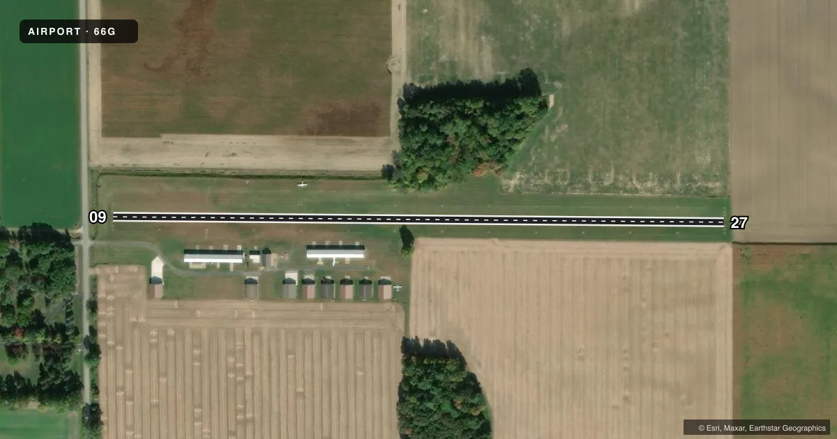
Airport sketch
Runways drawn to scale from FAA survey coordinates, rendered over satellite imagery. Not for navigation.
Approaches & charts
Services on the field
Fuel grades, oxygen, maintenance, ramp storage and lighting — as declared to the FAA by the airport operator.
Fuel & services
- Fuel
- Not available
- Oxygen (bottled)
- Not available
- Oxygen (bulk)
- Not available
- Airframe repair
- Not available
- Power plant repair
- Not available
- Other services
- INSTR
Ramp & ground
- Transient storage
- Tie-down
- Landing fee
- No fee published
- Wind indicator
- Lighted
- Segmented circle
- No
Fuel & FBOs
Cheapest 100LL and Jet A on the field and nearby. Always confirm with the FBO before taxi.
Airport notes
Surface conditions, obstructions, local procedures, lighting outages and other notes published with each FAA cycle.
General notes
- NO SNOW REMOVAL - CTC AMGR TO VFY FICON.
- RWY 09 -7 FT DITCH, 60 FT FM THR.
- RWY 27 +8 FT SEASONAL CROPS, 10 FT FM THR, 100 FT LEFT & RIGHT OF CNTRLN.
- FOR CD CTC GREAT LAKES APCH AT 269-459-3345, WHEN APCH CLSD CTC CLEVELAND ARTCC AT 440-774-0224/0490.
- DEER & LRG BIRDS ON & INVOF ARPT.
Approach & departure obstructions
- 09RWY & DTHR MKD WITH 3 FT YELLOW CONES.
- 273 FT YELLOW CONES.
- 09APCH RATIO 10:1 TO DTHR OVR +67 FT TREE, 670 FT DIST, 105 FT R.
Other notes
- 09/27SOFT IN SPRING & AFT HVY RAIN.
VFR map & nearby airports
VFR sectional. Tap any ICAO chip to open that airport.
Key facts · 66G
Answer card- ICAO
- 66G
- Name
- WM 'TINY' ZEHNDER FLD
- Location
- FRANKENMUTH, MICHIGAN
- Elevation
- 639 ft MSL
- Traffic pattern altitude
- 1,639 ft MSL (1,000 AGL)
- Control tower
- Non-towered (use CTAF)
- Total runways
- 1
- Longest runway
- 09/27 · 2,500 ft
- Published ILS approaches
- 0
- Published frequencies
- 1
- Magnetic variation
- 6°
- Current flight rules
- VFR
- Current wind
- 230° at 10 kt
- Favored runway now
- RWY 27
WM 'Tiny' Zehnder Fld sits in Frankenmuth, Michigan. The field elevation is 639 ft MSL. It has one runway. The longest runway is 2,500 ft of turf. There is no control tower. CTAF is 122.9. No ILS approaches are published here.
Pattern altitude is not published. Use 1,000 ft AGL for light piston operations unless the current Chart Supplement says otherwise. Deer and large birds are reported on and near the airport. The runway surface can be soft in spring and after heavy rain. Check field conditions before you go. There is no snow removal. Contact the airport manager to verify the surface before winter operations.
Runway 09 has a 7-foot ditch 60 feet from the threshold. Runway 09 and the displaced threshold are marked with 3-foot yellow cones. Runway 27 is also marked with 3-foot yellow cones. Runway 27 has seasonal crops near the threshold. They are reported 8 feet high, 10 feet from the threshold and 100 feet left and right of centerline. For clearance delivery, contact Great Lakes Approach. When approach is closed, contact Cleveland ARTCC. If you are planning a first visit, expect a turf strip with seasonal surface and wildlife issues. Verify current field conditions before departure.