METAR & TAF KFNT
Current METAR
Observed 21:00Z
KFNT 272100Z 22018G38KT 10SM -RA SCT030 SCT049 BKN070 24/20 A2964 RMK AO2 PK WND 21035/2054 WSHFT 2040 RAB2056 P0000 T02440200
- Wind
- 220° @ 18G38 kt
- Visibility
- 10 SM
- Temp / Dew
- 24°C / 20°C
- Altimeter
- 29.64 inHg
- Clouds
- BKN
- Density alt
- 2,397 ft
- Ceiling
- 7,000 ft AGL
- Rules
- VFR
Airport info & contacts
Manager on record, flight service, ARTCC, attendance schedule and pattern altitude — published by the FAA and refreshed every 28 days.
Location
- From city
- 4 NM SW
- VFR sectional
- DETROIT
- ARTCC
- ZOB · CLEVELAND
- NOTAM facility
- FNT (NOTAM-D)
Airport manager
- Name
- NINO SAPONE
- Phone
- 810-701-0992
- Address
- G-3425 W BRISTOL RD, FLINT MI 48507
Flight service · Hours
- FSS LAN
- LANSING1-800-WX-BRIEF
- Attendance
- ALL
Frequencies
Tap any row to copy the frequency to your clipboard.
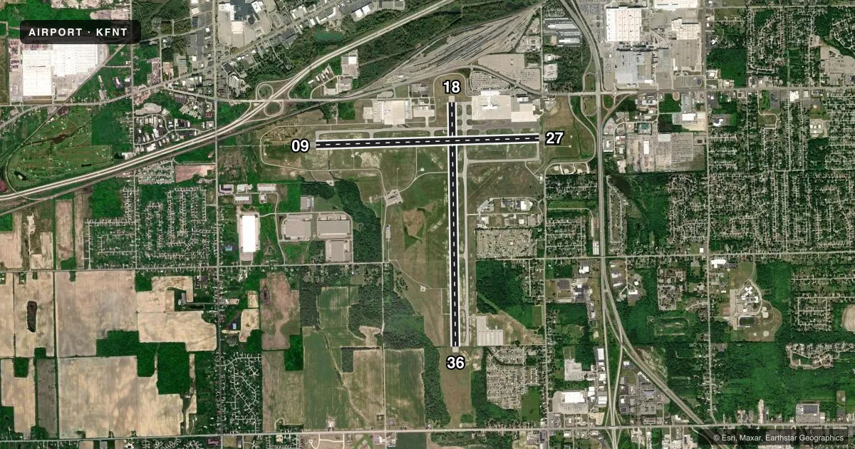
Runways & pattern
Full pagePattern entry · RWY 18
LEFT TRAFFIC| Runway | Heading (°M) | Length | Surface | Traffic |
|---|---|---|---|---|
| 18/36Favored | 173° / 353° | 7,852 ft | ASPH | Standard L |
| 09/27 | 82° / 262° | 7,201 ft | ASPH | Standard L |
Runway end performance
| End | TORA | TODA | ASDA | LDA | VGSI | Approach lights | Obstruction |
|---|---|---|---|---|---|---|---|
| 18 | 7,852' | 7,852' | 7,852' | 7,650' | PAPI 4-box right(3°) | — | 79', tree, 2229' from thr, 299' R of cntrln, slope 25 |
| 36 | 7,852' | 7,852' | 7,652' | 7,652' | PAPI 4-box left(3°) | — | 69', tree, 1945' from thr, 485' R of cntrln, slope 25 |
| 09 | 7,201' | 7,201' | 7,201' | 7,201' | PAPI 4-box right(3°) | MALSR | 60', trees, 2460' from thr, 540' R of cntrln, slope 37 |
| 27 | 7,201' | 7,201' | 7,201' | 7,201' | PAPI 4-box left(3°) | MALSR | 76', trees, 2968' from thr, 98' R of cntrln, slope 36 |
Declared distances in feet. TORA = takeoff run available, TODA = takeoff distance, ASDA = accelerate-stop, LDA = landing distance.
Airport sketch
Runways drawn to scale from FAA survey coordinates, rendered over satellite imagery. Not for navigation.
Approaches & charts
ILS · 2
Services on the field
Fuel grades, oxygen, maintenance, ramp storage and lighting — as declared to the FAA by the airport operator.
Fuel & services
- Fuel
- 100LLA
- Oxygen (bottled)
- Not available
- Airframe repair
- Major
- Power plant repair
- Major
- Other services
- AFRT,CARGO,CHTR,INSTR,SALES
Ramp & ground
- Transient storage
- Tie-down
- Hangar
- Customs
- Not available
- Lighting schedule
- SEE RMK
- Beacon schedule
- SS-SR
- Beacon
- White / Green (civil land)(WG)
- Wind indicator
- Lighted
- Segmented circle
- Yes
Fuel & FBOs
Cheapest 100LL and Jet A on the field and nearby. Always confirm with the FBO before taxi.
Airport notes
Surface conditions, obstructions, local procedures, lighting outages and other notes published with each FAA cycle.
General notes
- BIRDS & DEER ON & INVOF ARPT.
- FOR CD WHEN ATCT CLSD CTC GREAT LAKES APCH AT 269-459-3345, WHEN APCH CLSD CTC CLEVELAND ARTCC AT 440-774-0224/0490.
Lighting notes
- WHEN ATCT CLSD ACTVT MALSR RWY 09 & 27; REIL RWY 18 & 36; HIRL RWY 09/27 & 18/36 - CTAF.
Fuel notes
- 100LL100LL AVBL SELF SVC AT GOLF TEES.
Runway surface & condition
- 09/27PCR VALUE: 800/F/A/W/T
- 18/36PCR VALUE: 850/F/A/W/T
Approach & departure obstructions
- 18PAPI UNUSBL BYD 8 DEGS LEFT OF CNTRLN.
- 18APCH RATIO 28:1 TO DTHR.
VFR map & nearby airports
VFR sectional. Tap any ICAO chip to open that airport.
Key facts · KFNT
Answer card- ICAO
- KFNT
- Name
- BISHOP INTL
- Location
- FLINT, MICHIGAN
- Elevation
- 782.1 ft MSL
- Traffic pattern altitude
- 1,782.1 ft MSL (1,000 AGL)
- Control tower
- Towered · 0545-2330
- Total runways
- 2
- Longest runway
- 18/36 · 7,852 ft
- Published ILS approaches
- 2
- Published frequencies
- 12
- Magnetic variation
- 6°
- Current flight rules
- VFR
- Current wind
- 220° at 18 kt
- Favored runway now
- RWY 18
Bishop Intl sits in Flint, Michigan. The field elevation is 782.1 ft MSL. It has two asphalt runways. The longest is 7,852 ft on runway 18/36. The other runway is 09/27 at 7,201 ft. The airport is towered. The control tower is open 0545-2330. KFNT has 2 ILS approaches. Both are to runway ends 09 and 27. Pattern altitude is not published in the facts, so use 1,000 ft AGL for light piston traffic unless ATC or the current Chart Supplement says otherwise.
Avflight Flint is on the field. It carries 100LL, Jet A and Jet A Prist. If you need fuel after hours, the remarks say 100LL is available self-serve at Golf Tees. When the tower is closed, clearance delivery goes through Great Lakes Approach. When approach is closed, contact Cleveland ARTCC. The remarks also note birds and deer in and around the airport. Keep a sharp scan on taxi, takeoff and final. Runway 18 has a published PAPI limitation left of centerline. Runway 18/36 and 09/27 both have published pavement strength data. Heavier aircraft should verify suitability before arrival. With two long asphalt runways and Class C frequencies in use, this is a busy airport. Get the current Chart Supplement and brief the tower and approach procedures before you go.