METAR & TAF D95
Current METAR
Observed 18:35Z
KD95 271835Z AUTO 26006KT 10SM CLR 31/20 A2974 RMK AO2
- Wind
- 260° @ 6 kt
- Visibility
- 10 SM
- Temp / Dew
- 31°C / 20°C
- Altimeter
- 29.74 inHg
- Clouds
- CLR
- Density alt
- 3,178 ft
- Ceiling
- Unlimited
- Rules
- VFR
Airport info & contacts
Manager on record, flight service, ARTCC, attendance schedule and pattern altitude — published by the FAA and refreshed every 28 days.
Location
- From city
- 2 NM NE
- VFR sectional
- DETROIT
- ARTCC
- ZOB · CLEVELAND
- NOTAM facility
- D95 (NOTAM-D)
Airport manager
- Name
- JOHN M LEWIS
- Phone
- 810-441-4396
- Address
- 1232 ROODS LAKE RD, LAPEER MI 48446-7785
Flight service · Hours
- FSS LAN
- LANSING1-800-WX-BRIEF
- Attendance
- IREG
Frequencies
Tap any row to copy the frequency to your clipboard.
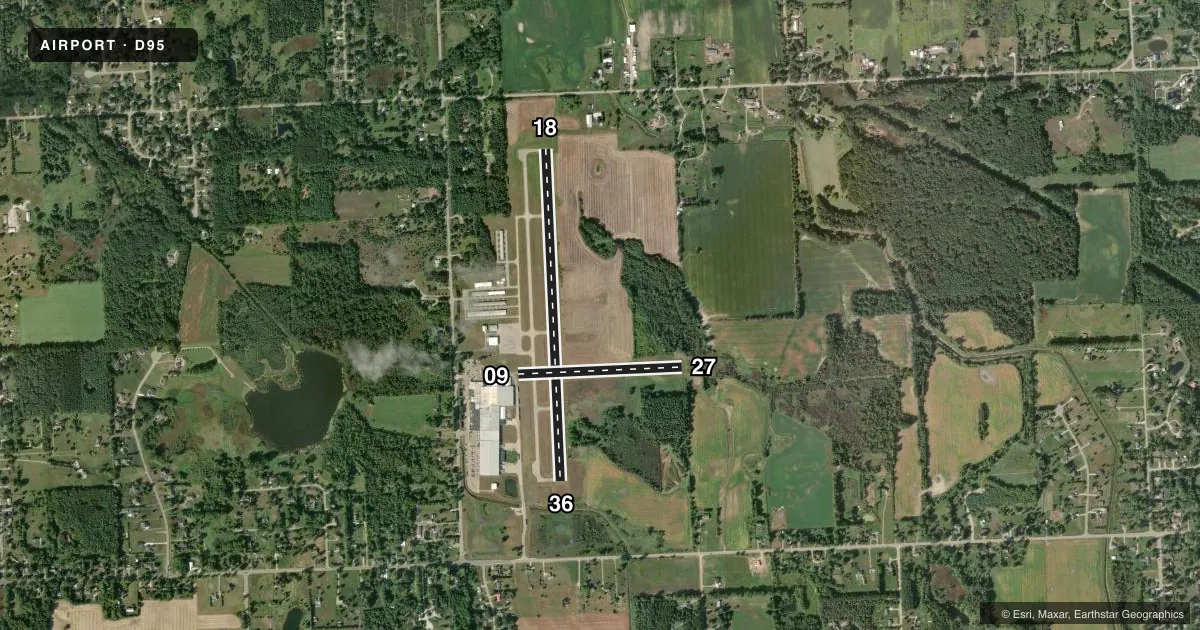
Runways & pattern
Full pagePattern entry · RWY 27
LEFT TRAFFIC| Runway | Heading (°M) | Length | Surface | Traffic |
|---|---|---|---|---|
| 18/36 | 170° / 350° | 3,800 ft | ASPH | Standard L |
| 09/27Favored | 81° / 261° | 1,879 ft | TURF | Standard L |
Runway end performance
| End | TORA | TODA | ASDA | LDA | VGSI | Approach lights | Obstruction |
|---|---|---|---|---|---|---|---|
| 18 | — | — | — | — | PAPI 4-box left(4°) | — | — |
| 36 | — | — | — | — | PAPI 4-box left(4°) | — | — |
| 09 | — | — | — | — | — | — | 14', road, 0' from thr, 125' R of cntrln, slope 0 |
| 27 | — | — | — | — | — | — | 13', trees, 0' from thr, 125' R of cntrln, slope 0 |
Declared distances in feet. TORA = takeoff run available, TODA = takeoff distance, ASDA = accelerate-stop, LDA = landing distance.
Airport sketch
Runways drawn to scale from FAA survey coordinates, rendered over satellite imagery. Not for navigation.
Approaches & charts
Services on the field
Fuel grades, oxygen, maintenance, ramp storage and lighting — as declared to the FAA by the airport operator.
Fuel & services
- Fuel
- 100LLA+
- Oxygen (bottled)
- Not available
- Oxygen (bulk)
- Not available
- Airframe repair
- Not available
- Power plant repair
- Not available
Ramp & ground
- Transient storage
- Tie-down
- Hangar
- Landing fee
- No fee published
- Customs
- Not available
- Lighting schedule
- SEE RMK
- Beacon schedule
- SS-SR
- Beacon
- White / Green (civil land)(WG)
- Wind indicator
- Lighted
- Segmented circle
- Yes
Fuel & FBOs
Cheapest 100LL and Jet A on the field and nearby. Always confirm with the FBO before taxi.
Airport notes
Surface conditions, obstructions, local procedures, lighting outages and other notes published with each FAA cycle.
General notes
- FOR CD CTC GREAT LAKES APCH AT 269-459-3345, WHEN APCH CLSD CTC CLEVELAND ARTCC AT 440-774-0224/0490.
- DEER & LRG BIRDS ON & INVOF ARPT.
- 26 FT MKD PLINE, 750 FT FM RWY END 36, 180 FT LEFT & RIGHT OF EXTDD CNTRLN.
Lighting notes
- ACTVT REIL RWY 18 & 36; PAPI RWY 18 & 36; MIRL RWY 18/36 - CTAF.
Runway surface & condition
- 09/27CLSD NOV-APR & WHEN SNOW COVD.
Approach & departure obstructions
- 09RWY & DTHR MKD WITH 3 FT YELLOW CONES.
- 273 FT YELLOW CONES.
- 09CTLNG OBSTN EXCEEDS A 45 DEG SLP. RWY 09 APCH RATIO 20:1 TO DTHR.
- 27CTLNG OBSTN EXCEEDS A 45 DEG SLP.
Other notes
- PRVDD THRS ARE LCTD TO PRVD A CLEAR 20:1 APCH & APROPLY MKD & LGTD.
- CTC AMGR FOR HNGR AVBLTY.
VFR map & nearby airports
VFR sectional. Tap any ICAO chip to open that airport.
Key facts · D95
Answer card- ICAO
- D95
- Name
- DUPONT/LAPEER
- Location
- LAPEER, MICHIGAN
- Elevation
- 834.6 ft MSL
- Traffic pattern altitude
- 1,834.6 ft MSL (1,000 AGL)
- Control tower
- Non-towered (use CTAF)
- Total runways
- 2
- Longest runway
- 18/36 · 3,800 ft
- Published ILS approaches
- 0
- Published frequencies
- 4
- Magnetic variation
- 7°
- Current flight rules
- VFR
- Current wind
- 260° at 6 kt
- Favored runway now
- RWY 27
Dupont/Lapeer Airport sits in Lapeer, Michigan. Field elevation is 834.6 ft MSL. The airport has two runways. The longest is 18/36 at 3,800 ft asphalt. Runway 09/27 is 1,879 ft turf. There is no control tower. No ILS approaches are published here. The pattern altitude is not published, so plan on the standard 1,000 ft AGL for light piston traffic unless the current FAA Chart Supplement says otherwise.
Lapeer Aviation is on the field. It carries AVGAS 100LL and Jet A with Prist. For clearance delivery, the published contact is Great Lakes Approach. When approach is closed, the remarks direct pilots to Cleveland ARTCC. Runway 18 and 36 have medium intensity lights, runway end identifier lights and PAPI. Those lights are controlled by CTAF. The turf runway has seasonal limits. Runways 09/27 are closed from November through April and when snow covered.
There are a few things to watch on a first visit. Deer and large birds are reported on and near the airport. Runway 09 has a ceiling obstruction note near the displaced threshold. Runway 27 also has an obstruction note. A marked power line sits near the departure end of 36. If you are planning a night or low-weather arrival, verify the current Chart Supplement and brief the runway lighting and obstacle notes before you go.