METAR & TAF 29C
29C does not publish a METAR.
Showing the nearest reporting station: KBAX (HURON COUNTY MEML) · 16.3 NM away. Conditions at 29C may differ.
METAR · KBAX
Observed 21:35Z
KBAX 272135Z AUTO 25005KT 10SM FEW120 27/20 A2969 RMK AO2
- Wind
- 250° @ 5 kt
- Visibility
- 10 SM
- Temp / Dew
- 27°C / 20°C
- Altimeter
- 29.69 inHg
- Clouds
- FEW
- Density alt
- 2,519 ft
- Ceiling
- Unlimited
- Rules
- VFR
Airport info & contacts
Manager on record, flight service, ARTCC, attendance schedule and pattern altitude — published by the FAA and refreshed every 28 days.
Location
- From city
- 4 NM E
- VFR sectional
- LAKE HURON
- ARTCC
- ZMP · MINNEAPOLIS
- NOTAM facility
- LAN (NOTAM-D)
Airport manager
- Name
- KELLY J HANSON
- Phone
- 989-269-7299
- Address
- 330 E HURON AVE, BAD AXE MI 48413-1449
Flight service · Hours
- FSS LAN
- LANSING1-800-WX-BRIEF
- Attendance
- Unattended
Frequencies
Tap any row to copy the frequency to your clipboard.
Runways & pattern
Full pagePattern entry · RWY 18
LEFT TRAFFICRunway end performance
| End | TORA | TODA | ASDA | LDA | VGSI | Approach lights | Obstruction |
|---|---|---|---|---|---|---|---|
| 18 | — | — | — | — | — | — | 18', trees, 0' from thr, 65' R of cntrln, slope 0 |
| 36 | — | — | — | — | — | — | 30', trees, 0' from thr, 65' R of cntrln, slope 0 |
Declared distances in feet. TORA = takeoff run available, TODA = takeoff distance, ASDA = accelerate-stop, LDA = landing distance.
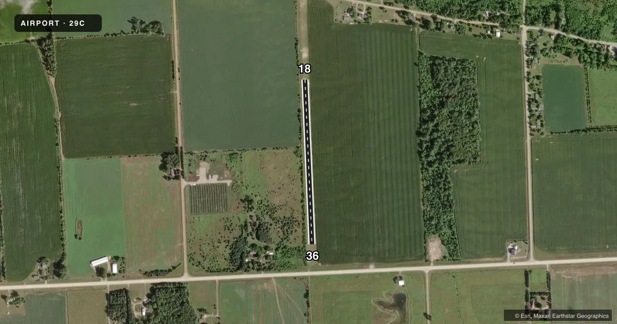
Airport sketch
Runways drawn to scale from FAA survey coordinates, rendered over satellite imagery. Not for navigation.
Approaches & charts
Services on the field
Fuel grades, oxygen, maintenance, ramp storage and lighting — as declared to the FAA by the airport operator.
Fuel & services
- Fuel
- Not available
Ramp & ground
- Transient storage
- Not published
- Wind indicator
- Yes
- Segmented circle
- No
Fuel & FBOs
Cheapest 100LL and Jet A on the field and nearby. Always confirm with the FBO before taxi.
Airport notes
Surface conditions, obstructions, local procedures, lighting outages and other notes published with each FAA cycle.
General notes
- FOR CD CTC MINNEAPOLIS ARTCC AT 651-463-5588.
- DEER & LRG BIRDS ON & INVOF ARPT.
Approach & departure obstructions
- 183 FT YELLOW CONES.
- 363 FT YELLOW CONES.
- 18CTLG OBSTN EXCEEDS A 45 DEG SLP. APCH RATIO 16:1 TO THR OVR +76 FT TREE, 1244 FT DIST, 42 FT L. APCH RATIO 20:1 OVR 27 FT PLINE, 570 FT DIST, 125 FT L/R.
- 36CTLG OBSTN EXCEEDS A 45 DEG SLP. APCH RATIO 20:1 OVR 25 FT PLINE, 720 FT DIST, 125 FT L/R.
Other notes
- MAN-MADE OR NATURAL OBJECTS EXIST WI THE ASP NEEDED TO ENSURE SAFETY IN THE TKOF/LDG OF ACFT.
VFR map & nearby airports
VFR sectional. Tap any ICAO chip to open that airport.
Key facts · 29C
Answer card- ICAO
- 29C
- Name
- GRINDSTONE AIR HARBOR
- Location
- PORT AUSTIN, MICHIGAN
- Elevation
- 640 ft MSL
- Traffic pattern altitude
- 1,640 ft MSL (1,000 AGL)
- Control tower
- Non-towered (use CTAF)
- Total runways
- 1
- Longest runway
- 18/36 · 1,800 ft
- Published ILS approaches
- 0
- Published frequencies
- 1
- Magnetic variation
- 7°
- Current flight rules
- VFR
- Current wind
- 250° at 5 kt
- Favored runway now
- RWY 18
Grindstone Air Harbor (29C) sits in Port Austin, Michigan. Field elevation is 640 ft MSL. The airport has one runway. Runway 18/36 is 1,800 ft of turf, so plan for short-field performance and soft-field technique. There is no control tower. CTAF is 122.9. No ILS approaches are published here.
Pattern altitude is not published. Use the standard 1,000 ft AGL unless the current Chart Supplement says otherwise. That puts the pattern at 1,640 ft MSL based on the field elevation. Published remarks note objects in the approach surfaces. There are also cataloged obstructions on both ends, including trees and power lines. Three-foot yellow cones mark the ends of Runway 18 and Runway 36. Deer and large birds are reported on and near the airport. Keep a sharp scan on arrival and departure.
No on-field FBOs are listed. If you need fuel or ground services, contact the airport operator directly or call the field on CTAF for current availability. Clearance delivery is handled through Minneapolis ARTCC at 651-463-5588. With a turf runway, obstruction notes and wildlife activity, this is a field where a current briefing matters before you go.