METAR & TAF KBAX
Current METAR
Observed 18:55Z
KBAX 271855Z AUTO 12006KT 10SM SCT028 SCT035 BKN048 23/20 A2974 RMK AO2
- Wind
- 120° @ 6 kt
- Visibility
- 10 SM
- Temp / Dew
- 23°C / 20°C
- Altimeter
- 29.74 inHg
- Clouds
- BKN
- Density alt
- 2,130 ft
- Ceiling
- 4,800 ft AGL
- Rules
- VFR
Airport info & contacts
Manager on record, flight service, ARTCC, attendance schedule and pattern altitude — published by the FAA and refreshed every 28 days.
Location
- From city
- 1 NM S
- VFR sectional
- DETROIT
- ARTCC
- ZOB · CLEVELAND
- NOTAM facility
- BAX (NOTAM-D)
Airport manager
- Name
- CHRIS JACKSON
- Phone
- 989-269-6511
- Address
- 352 THOMPSON RD, BAD AXE MI 48413-9491
Flight service · Hours
- FSS LAN
- LANSING1-800-WX-BRIEF
- Attendance
- MON-FRI · 0830-1630
Frequencies
Tap any row to copy the frequency to your clipboard.
Runways & pattern
Full pagePattern entry · RWY 17
LEFT TRAFFIC| Runway | Heading (°M) | Length | Surface | Traffic |
|---|---|---|---|---|
| 17/35Favored | 160° / 340° | 5,000 ft | ASPH | Standard L |
| 04/22 | 23° / 203° | 3,495 ft | ASPH | Standard L |
Runway end performance
| End | TORA | TODA | ASDA | LDA | VGSI | Approach lights | Obstruction |
|---|---|---|---|---|---|---|---|
| 17 | — | — | — | — | PAPI 4-box left(3°) | — | 56', trees, 1349' from thr, 250' R of cntrln, slope 20 |
| 35 | — | — | — | — | PAPI 4-box left(3°) | — | — |
| 04 | — | — | — | — | PAPI 4-box left(3°) | — | 21', rr, 266' from thr, 260' R of cntrln, slope 3 |
| 22 | — | — | — | — | PAPI 4-box left(3.5°) | — | 51', trees, 716' from thr, 348' R of cntrln, slope 10 |
Declared distances in feet. TORA = takeoff run available, TODA = takeoff distance, ASDA = accelerate-stop, LDA = landing distance.
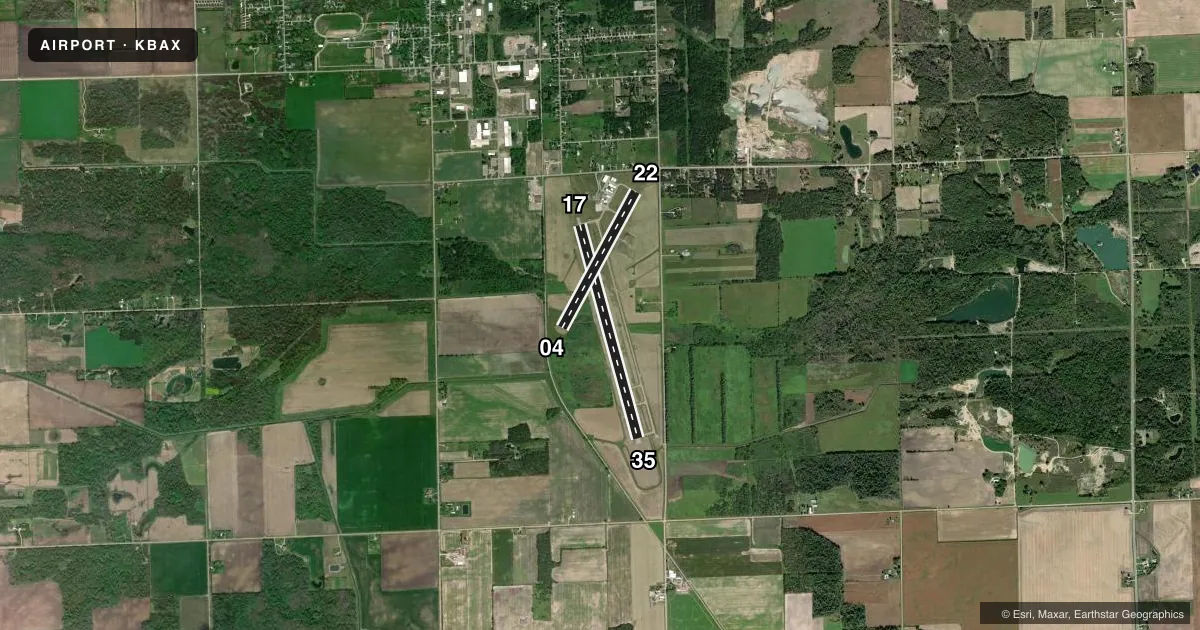
Airport sketch
Runways drawn to scale from FAA survey coordinates, rendered over satellite imagery. Not for navigation.
Approaches & charts
Services on the field
Fuel grades, oxygen, maintenance, ramp storage and lighting — as declared to the FAA by the airport operator.
Fuel & services
- Fuel
- 100LLA+
Ramp & ground
- Transient storage
- Tie-down
- Landing fee
- No fee published
- Customs
- Not available
- Lighting schedule
- SEE RMK
- Beacon schedule
- SS-SR
- Beacon
- White / Green (civil land)(WG)
- Wind indicator
- Lighted
- Segmented circle
- Yes
Fuel & FBOs
Cheapest 100LL and Jet A on the field and nearby. Always confirm with the FBO before taxi.
Airport notes
Surface conditions, obstructions, local procedures, lighting outages and other notes published with each FAA cycle.
General notes
- DEER & LRG BIRDS ON & INVOF ARPT.
- ADMIN BLDG ACES: PRESS V, THEN III & II SIMUL, THEN I.
- TURBO PROP & JET LANDING FEE WAIVED WITH FUEL PURCHASE.
- FOR CD CTC CLEVELAND ARTCC AT 440-774-0224/0490.
Lighting notes
- MIRL RYS 04/22 & 17/35 OPER DUSK-2130; TO INCR INTST & AFT 2130 ACTVT - CTAF. ACTVT PAPI RYS 4, 17, 22, & 35 AND REIL RYS 17 & 35 - CTAF.
Approach & departure obstructions
- 04APCH SLP 20:1 TO DTHR.
Other notes
- 1ARPT UNATNDD WEEKENDS & MAJOR HOLS.
VFR map & nearby airports
VFR sectional. Tap any ICAO chip to open that airport.
Key facts · KBAX
Answer card- ICAO
- KBAX
- Name
- HURON COUNTY MEML
- Location
- BAD AXE, MICHIGAN
- Elevation
- 763.8 ft MSL
- Traffic pattern altitude
- 1,763.8 ft MSL (1,000 AGL)
- Control tower
- Non-towered (use CTAF)
- Total runways
- 2
- Longest runway
- 17/35 · 5,000 ft
- Published ILS approaches
- 0
- Published frequencies
- 2
- Magnetic variation
- 5°
- Current flight rules
- VFR
- Current wind
- 120° at 6 kt
- Favored runway now
- RWY 17
Huron County Meml is in Bad Axe, Michigan. The field elevation is 763.8 ft MSL. It has two asphalt runways. The longest is runway 17/35 at 5,000 ft. Runway 04/22 is 3,495 ft.
This is an unattended airport with no control tower. CTAF and UNICOM are both 123.075. No ILS approaches are published here, so plan with the current chart and your own avionics setup. The pattern altitude is not published. Use 1,000 ft AGL for light piston operations unless the current Chart Supplement says otherwise.
Bayfront Aviation is on the field. It carries 100LL and Jet A Prist. Clearance delivery goes through Cleveland ARTCC. The airport remarks also call out deer and large birds in the area, so keep a sharp scan on departure and arrival. Runway lights on both runways operate from dusk to 2130. After 2130, use CTAF to increase intensity. PAPI is activated on runways 04, 17, 22 and 35 via CTAF. REIL is available on 17 and 35 via CTAF. The airport is unattended on weekends and major holidays. Runway 04 has a displaced threshold with a 20:1 approach slope to that threshold, so brief that segment carefully before you go in.