METAR & TAF 96G
96G does not publish a METAR.
Showing the nearest reporting station: KBAX (HURON COUNTY MEML) · 25.3 NM away. Conditions at 96G may differ.
METAR · KBAX
Observed 19:55Z
KBAX 231955Z AUTO 36010G18KT 10SM SCT002 20/10 A3015 RMK AO2
- Wind
- 360° @ 10G18 kt
- Visibility
- 10 SM
- Temp / Dew
- 20°C / 10°C
- Altimeter
- 30.15 inHg
- Clouds
- SCT
- Density alt
- 1,270 ft
- Ceiling
- Unlimited
- Rules
- VFR
Airport info & contacts
Manager on record, flight service, ARTCC, attendance schedule and pattern altitude — published by the FAA and refreshed every 28 days.
Location
- From city
- 3 NM S
- VFR sectional
- DETROIT
- ARTCC
- ZOB · CLEVELAND
- NOTAM facility
- LAN (NOTAM-D)
Airport manager
- Name
- DALE COWLEY
- Phone
- 810-837-0111
- Address
- 1515 S SANDUSKY RD, SANDUSKY MI 48471-8956
Flight service · Hours
- FSS LAN
- LANSING1-800-WX-BRIEF
- Attendance
- IREG
Frequencies
Tap any row to copy the frequency to your clipboard.
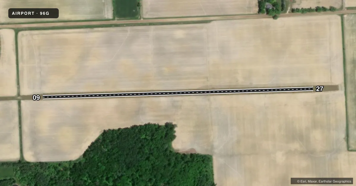
Runways & pattern
Full pagePattern entry · RWY 09
LEFT TRAFFICAirport sketch
Runways drawn to scale from FAA survey coordinates, rendered over satellite imagery. Not for navigation.
Approaches & charts
Services on the field
Fuel grades, oxygen, maintenance, ramp storage and lighting — as declared to the FAA by the airport operator.
Fuel & services
- Fuel
- Not available
- Oxygen (bottled)
- Not available
- Oxygen (bulk)
- Not available
- Airframe repair
- Not available
- Power plant repair
- Not available
Ramp & ground
- Transient storage
- Tie-down
- Landing fee
- No fee published
- Wind indicator
- Yes
- Segmented circle
- No
Fuel & FBOs
Cheapest 100LL and Jet A on the field and nearby. Always confirm with the FBO before taxi.
Airport notes
Surface conditions, obstructions, local procedures, lighting outages and other notes published with each FAA cycle.
General notes
- DEER & LRG BIRDS ON & INVOF ARPT.
- PWR POLES IN CLOSE PROXIMITY ALG TWY ON WEST END.
- FOR CD CTC CLEVELAND ARTCC AT 440-774-0224/0490.
- SNOW REMOVAL IREG - CALL AMGR TO VFY CONDS.
Approach & departure obstructions
- 093 FT YELLOW CONES.
- 273 FT YELLOW CONES.
VFR map & nearby airports
VFR sectional. Tap any ICAO chip to open that airport.
Key facts · 96G
Answer card- ICAO
- 96G
- Name
- COWLEY FLD
- Location
- SANDUSKY, MICHIGAN
- Elevation
- 770 ft MSL
- Traffic pattern altitude
- 1,770 ft MSL (1,000 AGL)
- Control tower
- Non-towered (use CTAF)
- Total runways
- 1
- Longest runway
- 09/27 · 2,600 ft
- Published ILS approaches
- 0
- Published frequencies
- 1
- Magnetic variation
- 7°
- Current flight rules
- VFR
- Current wind
- 360° at 10 kt
- Favored runway now
- RWY 09
Cowley Fld (96G) is in Sandusky, Michigan. The field elevation is 770 ft MSL. It has one runway. The longest runway is 2,600 ft of turf. There is no control tower. CTAF is 122.9.
No ILS approaches are published here. The pattern altitude is not published, so use the standard 1,000 ft AGL for light piston operations unless the current FAA Chart Supplement says otherwise. The runway headings are 88° and 268° magnetic. That matters on a short turf strip with a narrow margin for setup.
There are no on-field FBOs listed in the facts. Contact the airport operator directly or call the field on CTAF for current services before you go. Published remarks call out deer and large birds in and near the airport. Snow removal is irregular, so verify surface condition before a winter arrival. The west end taxiway also has power poles close by. Three foot yellow cones mark the ends of both runway directions. For clearance delivery, Cleveland ARTCC is the published contact. A first-time pilot should plan for a non-towered turf field. Watch for wildlife. Confirm the runway is usable before committing.