METAR & TAF 76G
76G does not publish a METAR.
Showing the nearest reporting station: KPHN (ST CLAIR COUNTY INTL) · 11.8 NM away. Conditions at 76G may differ.
METAR · KPHN
Observed 23:35Z
KPHN 272335Z AUTO 00000KT 10SM CLR 27/18 A2969 RMK AO2
- Wind
- 000° @ 0 kt
- Visibility
- 10 SM
- Temp / Dew
- 27°C / 18°C
- Altimeter
- 29.69 inHg
- Clouds
- CLR
- Density alt
- 2,486 ft
- Ceiling
- Unlimited
- Rules
- VFR
Airport info & contacts
Manager on record, flight service, ARTCC, attendance schedule and pattern altitude — published by the FAA and refreshed every 28 days.
Location
- From city
- 4 NM W
- VFR sectional
- DETROIT
- ARTCC
- ZOB · CLEVELAND
- NOTAM facility
- LAN (NOTAM-D)
Airport manager
- Name
- PENNY FAUCHER
- Phone
- 810-765-8289
- Address
- 7115 MARINE CITY HWY, COTTRELLVILLE MI 48039-1008
Flight service · Hours
- FSS LAN
- LANSING1-800-WX-BRIEF
- Attendance
- SAT-SUN · ON CALL
- MON-FRI · 0800-1700
Frequencies
Tap any row to copy the frequency to your clipboard.
Runways & pattern
Full pagePattern entry · RWY 04
LEFT TRAFFICRunway end performance
| End | TORA | TODA | ASDA | LDA | VGSI | Approach lights | Obstruction |
|---|---|---|---|---|---|---|---|
| 04 | — | — | — | — | PAPI 2-box left(4°) | — | 100', pline, 2000' from thr, 125' R of cntrln, slope 18 |
| 22 | — | — | — | — | PAPI 2-box left(4°) | — | — |
Declared distances in feet. TORA = takeoff run available, TODA = takeoff distance, ASDA = accelerate-stop, LDA = landing distance.
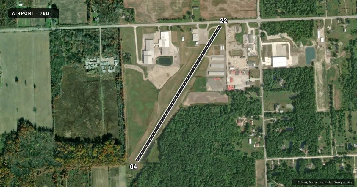
Airport sketch
Runways drawn to scale from FAA survey coordinates, rendered over satellite imagery. Not for navigation.
Approaches & charts
Services on the field
Fuel grades, oxygen, maintenance, ramp storage and lighting — as declared to the FAA by the airport operator.
Fuel & services
- Fuel
- 100LL
- Airframe repair
- Major
- Power plant repair
- Major
Ramp & ground
- Transient storage
- Tie-down
- Hangar
- Lighting schedule
- SEE RMK
- Beacon schedule
- SS-SR
- Beacon
- White / Green (civil land)(WG)
- Wind indicator
- Lighted
- Segmented circle
- Yes
Fuel & FBOs
Cheapest 100LL and Jet A on the field and nearby. Always confirm with the FBO before taxi.
Airport notes
Surface conditions, obstructions, local procedures, lighting outages and other notes published with each FAA cycle.
General notes
- FOR CD CTC SELFRIDGE APCH ON FREQ 119.6 OR CALL 586-239-5706, WHEN APCH CLSD CTC CLEVELAND ARTCC ON FREQ 132.25 OR CALL 440-774-0448/0490.
- FOR FICONS CTC AMGR.
- DEER & LRG BIRDS ON & INVOF ARPT.
Lighting notes
- ACTVT PAPI RWY 04 & 22; NSTD MIRL RWY 04/22 - CTAF.
Runway surface & condition
- 04/22NSTD MIRL DUE TO LCTN 23 FT FM RWY EDGE.
Approach & departure obstructions
- 04+12 FT TREE, 150 FT DIST, 125 FT L.
- 22+15 FT ROAD, 65 FT DIST, 125 FT L/R.
- 22APCH RATIO 20:1 TO DTHR.
Other notes
- 1FOR SVC CTC AMGR CELL.
- MANAGERCELL 810-650-7519.
VFR map & nearby airports
VFR sectional. Tap any ICAO chip to open that airport.
Key facts · 76G
Answer card- ICAO
- 76G
- Name
- MARINE CITY
- Location
- MARINE CITY, MICHIGAN
- Elevation
- 613.8 ft MSL
- Traffic pattern altitude
- 1,613.8 ft MSL (1,000 AGL)
- Control tower
- Non-towered (use CTAF)
- Total runways
- 1
- Longest runway
- 04/22 · 3,070 ft
- Published ILS approaches
- 0
- Published frequencies
- 2
- Magnetic variation
- 6°
- Current flight rules
- VFR
- Current wind
- 000° at 0 kt
- Favored runway now
- –
Marine City Airport sits in Marine City, Michigan. The field elevation is 613.8 ft MSL. It has one runway, 04/22, which is 3,070 ft long and paved with asphalt. There is no control tower. CTAF and UNICOM are both 123.0. No ILS approaches are published here.
Pattern altitude is not published, so use the standard 1,000 ft AGL for light piston operations unless the current Chart Supplement says otherwise. That puts the traffic pattern around 1,614 ft MSL based on the field elevation. Marine City Aviation is on the field. It carries 100LL. For service, call the manager or the FBO directly before you go.
A few remarks matter for planning. PAPI is available for runways 04 and 22. Medium intensity runway lights are not standard. The airport also has reported obstructions near both ends. There is a 12 ft tree near runway 04. There is also a road near runway 22. Deer and large birds are reported on and near the airport, so keep a sharp scan on arrival and departure. For clearance delivery, use Selfridge Approach when it is open. If approach is closed, the published contact is Cleveland ARTCC. For a first trip in, verify current notes in the Chart Supplement and expect a quiet non-towered field with local traffic on CTAF.