METAR & TAF 52I
52I does not publish a METAR.
Showing the nearest reporting station: KIKW (JACK BARSTOW) · 15.4 NM away. Conditions at 52I may differ.
METAR · KIKW
Observed 20:16Z
KIKW 272016Z AUTO 17004KT 10SM CLR 27/18 A2971 RMK AO2 PRESFR
- Wind
- 170° @ 4 kt
- Visibility
- 10 SM
- Temp / Dew
- 27°C / 18°C
- Altimeter
- 29.71 inHg
- Clouds
- CLR
- Density alt
- 2,467 ft
- Ceiling
- Unlimited
- Rules
- VFR
Airport info & contacts
Manager on record, flight service, ARTCC, attendance schedule and pattern altitude — published by the FAA and refreshed every 28 days.
Location
- From city
- 3 NM W
- VFR sectional
- DETROIT
- ARTCC
- ZOB · CLEVELAND
- NOTAM facility
- LAN (NOTAM-D)
Airport manager
- Name
- JAMES M KLEIN
- Phone
- 989-708-7583
- Address
- 706 5TH ST, BOX 31, PINCONNING MI 48650-8730
Flight service · Hours
- FSS LAN
- LANSING1-800-WX-BRIEF
- Attendance
- IREG
Frequencies
Tap any row to copy the frequency to your clipboard.
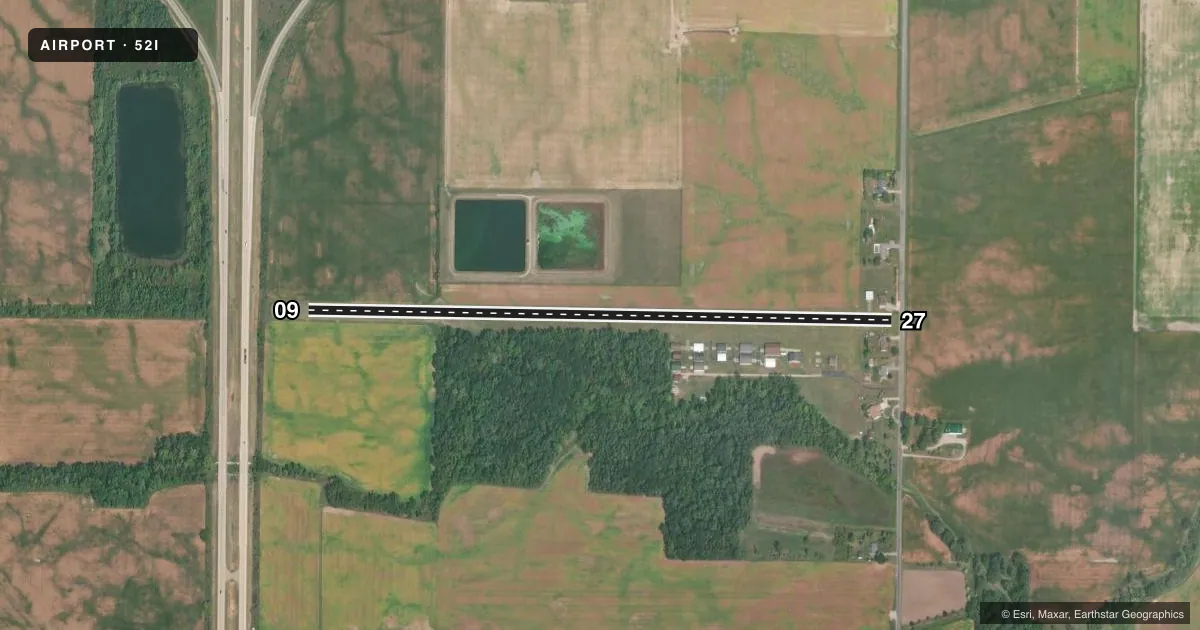
Runways & pattern
Full pagePattern entry · RWY 09
LEFT TRAFFICRunway end performance
| End | TORA | TODA | ASDA | LDA | VGSI | Approach lights | Obstruction |
|---|---|---|---|---|---|---|---|
| 09 | — | — | — | — | — | — | 60', trees, 588' from thr, 10' R of cntrln, slope 9 |
| 27 | — | — | — | — | — | — | 45', tree, 10' from thr, 118' R of cntrln, slope 1 |
Declared distances in feet. TORA = takeoff run available, TODA = takeoff distance, ASDA = accelerate-stop, LDA = landing distance.
Airport sketch
Runways drawn to scale from FAA survey coordinates, rendered over satellite imagery. Not for navigation.
Approaches & charts
Services on the field
Fuel grades, oxygen, maintenance, ramp storage and lighting — as declared to the FAA by the airport operator.
Fuel & services
- Fuel
- 100LL
- Oxygen (bottled)
- Not available
- Oxygen (bulk)
- Not available
- Airframe repair
- Not available
- Power plant repair
- Not available
Ramp & ground
- Transient storage
- Tie-down
- Landing fee
- No fee published
- Lighting schedule
- SEE RMK
- Wind indicator
- Yes
- Segmented circle
- No
Fuel & FBOs
Cheapest 100LL and Jet A on the field and nearby. Always confirm with the FBO before taxi.
Airport notes
Surface conditions, obstructions, local procedures, lighting outages and other notes published with each FAA cycle.
General notes
- FOR FICONS CALL 989-239-9878.
- BLDGS IN PRI SFC EAST END, 70 FT NORTH & 93 FT SOUTH OF CNTRLN; 15-45 FT TREES, 95 FT SOUTH OF CNTRLN WEST END.
- -6 FT DITCH, 5 FT WEST OF RWY END 09.
- ULTRALIGHTS USE 500 FT TPA.
- FOR CD CTC GREAT LAKES APCH AT 269-459-3345, WHEN APCH CLSD CTC CLEVELAND ARTCC AT 440-774-0224/0490.
- DEER & LRG BIRDS ON & INVOF ARPT.
Lighting notes
- ACTVT LIRL RWY 09/27 - CTAF.
Fuel notes
- 100LLFUEL AVBL FOR LCL CLUB PILOTS OR EMERG USE ONLY.
Approach & departure obstructions
- 09RWY & DTHR MKD WITH 3 FT YELLOW CONES.
- 27RWY & DTHR MKD WITH 3 FT YELLOW CONES.
- 09APCH RATIO 20:1 TO DTHR.
- 27APCH RATIO 10:1 TO DTHR OVR +45 FT TREE, 477 FT DIST, 118 FT R.
Other notes
- PRVDD THRS DSPLCD & CLEARLY MKD TO PRVD MNM 20:1 CLNC OVR OBSTNS.
- 1FOR SVC CALL 989-239-9878.
- MANAGERASST AMGR MICHAEL HARTMAN.
- MANAGERASST AMGR 989-239-9878.
VFR map & nearby airports
VFR sectional. Tap any ICAO chip to open that airport.
Key facts · 52I
Answer card- ICAO
- 52I
- Name
- GROSS
- Location
- PINCONNING, MICHIGAN
- Elevation
- 618 ft MSL
- Traffic pattern altitude
- 1,618 ft MSL (1,000 AGL)
- Control tower
- Non-towered (use CTAF)
- Total runways
- 1
- Longest runway
- 09/27 · 3,300 ft
- Published ILS approaches
- 0
- Published frequencies
- 1
- Magnetic variation
- 6°
- Current flight rules
- VFR
- Current wind
- 170° at 4 kt
- Favored runway now
- RWY 09
GROSS (52I) sits near Pinconning, Michigan. Field elevation is 618 ft MSL. The airport has one runway. Runway 09/27 is 3,300 ft of turf, which makes it a short-field planning airport for many pilots. There is no control tower. CTAF is 122.9.
No ILS approaches are published here. The published pattern altitude is not listed for the airport, so verify the current Chart Supplement before you go. Ultralights use 500 ft traffic pattern altitude. That is a separate published note.
There are no on-field FBOs listed. For service or flight information, call 989-239-9878. Clearance delivery is handled through Great Lakes Approach at 269-459-3345. When approach is closed, contact Cleveland ARTCC at 440-774-0224 or 440-774-0490.
The published remarks matter here. Runway and displaced threshold markings use 3-foot yellow cones at both ends. The thresholds are displaced to provide minimum 20 to 1 clearance over obstructions. There are buildings in the primary surface at the east end. Trees are reported near the west end. Deer and large birds are also reported on and near the airport. Plan your arrival with that in mind, especially on a turf strip with displaced thresholds and nearby obstacles.