METAR & TAF 80D
80D does not publish a METAR.
Showing the nearest reporting station: KGDW (GLADWIN ZETTEL MEML) · 15.4 NM away. Conditions at 80D may differ.
METAR · KGDW
Observed 19:15Z
KGDW 271915Z AUTO 26007G18KT 10SM CLR 26/18 A2975 RMK AO2 LTG DSNT N-E PRESRR
- Wind
- 260° @ 7G18 kt
- Visibility
- 10 SM
- Temp / Dew
- 26°C / 18°C
- Altimeter
- 29.75 inHg
- Clouds
- CLR
- Density alt
- 2,947 ft
- Ceiling
- Unlimited
- Rules
- VFR
Airport info & contacts
Manager on record, flight service, ARTCC, attendance schedule and pattern altitude — published by the FAA and refreshed every 28 days.
Location
- From city
- 2 NM NNW
- VFR sectional
- LAKE HURON
- ARTCC
- ZMP · MINNEAPOLIS
- NOTAM facility
- LAN (NOTAM-D)
Airport manager
- Name
- EMERSON CORDER
- Phone
- 989-329-3981
- Address
- 5700 N CLARE AVE, HARRISON MI 48625-8713
Flight service · Hours
- FSS LAN
- LANSING1-800-WX-BRIEF
- Attendance
- Unattended
Frequencies
Tap any row to copy the frequency to your clipboard.
Runways & pattern
Full pagePattern entry · RWY 27
LEFT TRAFFIC| Runway | Heading (°M) | Length | Surface | Traffic |
|---|---|---|---|---|
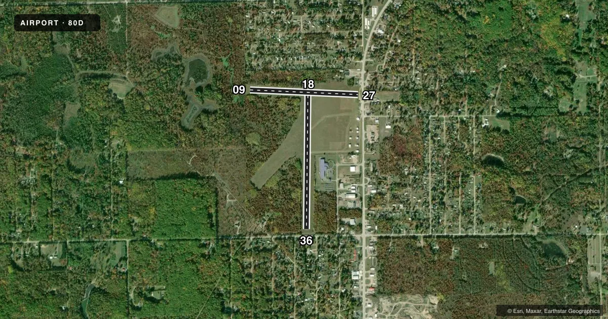
| 18/36 | 176° / 356° | 2,978 ft | ASPH | Standard L |
| 09/27Favored | 88° / 268° | 2,403 ft | TURF | Standard L |
Runway end performance
| End | TORA | TODA | ASDA | LDA | VGSI | Approach lights | Obstruction |
|---|---|---|---|---|---|---|---|
| 18 | — | — | — | — | — | — | 35', tree, 320' from thr, 120' R of cntrln, slope 3 |
| 36 | — | — | — | — | — | — | 63', tree, 200' from thr, 0' R of cntrln, slope 0 |
| 09 | — | — | — | — | — | — | 54', tree, 0' from thr, 125' R of cntrln, slope 0 |
| 27 | — | — | — | — | — | — | 88', tree, 273' from thr, 169' R of cntrln, slope 3 |
Declared distances in feet. TORA = takeoff run available, TODA = takeoff distance, ASDA = accelerate-stop, LDA = landing distance.
Airport sketch
Runways drawn to scale from FAA survey coordinates, rendered over satellite imagery. Not for navigation.
Approaches & charts
Services on the field
Fuel grades, oxygen, maintenance, ramp storage and lighting — as declared to the FAA by the airport operator.
Fuel & services
- Fuel
- Not available
- Oxygen (bottled)
- Not available
- Oxygen (bulk)
- Not available
- Airframe repair
- Not available
- Power plant repair
- Not available
Ramp & ground
- Transient storage
- Tie-down
- Landing fee
- No fee published
- Customs
- Not available
- Lighting schedule
- SEE RMK
- Beacon schedule
- SS-SR
- Beacon
- White / Green (civil land)(WG)
- Wind indicator
- Lighted
- Segmented circle
- No
Fuel & FBOs
Cheapest 100LL and Jet A on the field and nearby. Always confirm with the FBO before taxi.
Airport notes
Surface conditions, obstructions, local procedures, lighting outages and other notes published with each FAA cycle.
General notes
- DEER & LRG BIRDS ON & INVOF ARPT.
- FOR CD CTC MINNEAPOLIS ARTCC AT 651-463-5588.
Lighting notes
- ACTVT HIRL RWY 18/36 - CTAF.
Runway surface & condition
- 09/27CLSD NOV-MAR & WHEN SNOW COVD EXC FOR SKI EQUIPPED ACFT.
Approach & departure obstructions
- 364 FT FENCE, 75 FT DIST, L/R; 30 FT PLINE, 177 FT DIST, L/R; 70 FT TREES, 199 FT DIST, L/R.
- 09RWY & DTHR MKD WITH 3 FT YELLOW CONES.
- 27RWY & DTHR MKD WITH 3 FT YELLOW CONES.
- 09APCH RATIO 20:1 TO DTHR.
- 18APCH RATIO 20:1 TO DTHR.
- 27APCH RATIO 20:1 TO DTHR.
- 36APCH RATIO 20:1 TO DTHR.
Other notes
- PILOTS MUST SUP ROPES; LCTD ON NE SIDE ALG FENCE, NORTH OF TAN HNGR & SOUTH OF RESTAURANT.
- MANAGERRES.
- 09/27INTMT PATCHES OF MISG TURF THRUT FULL LEN & WID.
VFR map & nearby airports
VFR sectional. Tap any ICAO chip to open that airport.
Key facts · 80D
Answer card- ICAO
- 80D
- Name
- CLARE COUNTY
- Location
- HARRISON, MICHIGAN
- Elevation
- 1,142 ft MSL
- Traffic pattern altitude
- 2,142 ft MSL (1,000 AGL)
- Control tower
- Non-towered (use CTAF)
- Total runways
- 2
- Longest runway
- 18/36 · 2,978 ft
- Published ILS approaches
- 0
- Published frequencies
- 2
- Magnetic variation
- 5°
- Current flight rules
- VFR
- Current wind
- 260° at 7 kt
- Favored runway now
- RWY 27
Clare County Airport (80D) sits in Harrison, Michigan. Field elevation is 1,142 ft MSL. The airport has two runways. The longest is runway 18/36 at 2,978 ft. Runway 09/27 is turf and measures 2,403 ft. There is no control tower. CTAF and UNICOM are both 122.8.
No ILS approaches are published here. Pattern altitude is not published in the facts, so plan to verify the current traffic pattern in the FAA Chart Supplement before you go. The published remarks matter here. Runway 09/27 is closed from November through March. It is also closed when snow covered unless the aircraft is ski equipped. The turf runway has intermittent patches of missing turf across its full length and width. Runway 18/36 has high intensity runway lights that are activated on CTAF.
There are no on-field FBOs listed. Plan ahead for services before arrival. The field also has published obstructions near runway 36, plus deer and large birds in the area. Clearance delivery is handled through Minneapolis ARTCC at 651-463-5588. If you are new to 80D, treat it as a small uncontrolled field with seasonal turf limits, wildlife and a short paved runway that deserves a careful performance check.