METAR & TAF 4Y4
4Y4 does not publish a METAR.
Showing the nearest reporting station: KGLR (GAYLORD RGNL) · 9.5 NM away. Conditions at 4Y4 may differ.
METAR · KGLR
Observed 18:53Z
KGLR 271853Z AUTO VRB04KT 10SM FEW022 SCT120 27/21 A2972 RMK AO2 SLP055 T02720211
- Wind
- VAR @ 4 kt
- Visibility
- 10 SM
- Temp / Dew
- 27°C / 21°C
- Altimeter
- 29.72 inHg
- Clouds
- SCT
- Density alt
- 3,284 ft
- Ceiling
- Unlimited
- Rules
- VFR
Airport info & contacts
Manager on record, flight service, ARTCC, attendance schedule and pattern altitude — published by the FAA and refreshed every 28 days.
Location
- From city
- 11 NM SW
- VFR sectional
- LAKE HURON
- ARTCC
- ZMP · MINNEAPOLIS
- NOTAM facility
- LAN (NOTAM-D)
Airport manager
- Name
- DARYN HOOGERHYDE
- Phone
- 231-585-6000
- Address
- 5950 SKYTRAILS CT, MANCELONA MI 49659-9174
Flight service · Hours
- FSS LAN
- LANSING1-800-WX-BRIEF
- Attendance
- MON-FRI · 0900-1700
- SAT · 0900-1300
Frequencies
Tap any row to copy the frequency to your clipboard.
Runways & pattern
Full pagePattern entry · RWY 06
LEFT TRAFFICRunway end performance
| End | TORA | TODA | ASDA | LDA | VGSI | Approach lights | Obstruction |
|---|---|---|---|---|---|---|---|
| 06 | — | — | — | — | — | — | 4', road, 224' from thr, 125' R of cntrln, slope 6 |
| 24 | — | — | — | — | — | — | 4', fence, 201' from thr, 123' R of cntrln, slope 1 |
Declared distances in feet. TORA = takeoff run available, TODA = takeoff distance, ASDA = accelerate-stop, LDA = landing distance.
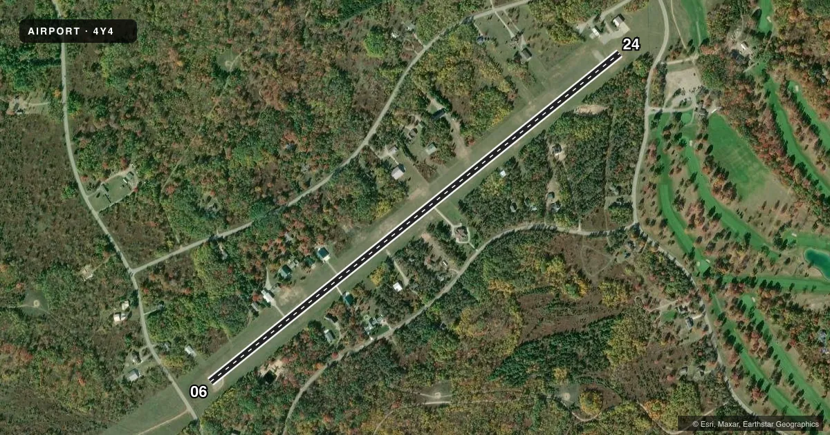
Airport sketch
Runways drawn to scale from FAA survey coordinates, rendered over satellite imagery. Not for navigation.
Approaches & charts
Services on the field
Fuel grades, oxygen, maintenance, ramp storage and lighting — as declared to the FAA by the airport operator.
Fuel & services
- Fuel
- Not available
- Airframe repair
- Not available
- Power plant repair
- Not available
Ramp & ground
- Transient storage
- Tie-down
- Landing fee
- No fee published
- Lighting schedule
- SEE RMK
- Beacon schedule
- SS-SR
- Beacon
- White / Green (civil land)(WG)
- Wind indicator
- Lighted
- Segmented circle
- No
Fuel & FBOs
Cheapest 100LL and Jet A on the field and nearby. Always confirm with the FBO before taxi.
Airport notes
Surface conditions, obstructions, local procedures, lighting outages and other notes published with each FAA cycle.
General notes
- DEER & LRG BIRDS ON & INVOF ARPT.
- RWY UPSLOPE FM EAST TO WEST, APRXLY 20 FT HYR ON WEST END.
- GOLF CRS & RESTAURANT ADJ.
- UAS OPS INVOF ARPT.
- FOR CD CTC MINNEAPOLIS ARTCC AT 651-463-5588.
Lighting notes
- ACTVT LIRL RWY 06/24 - CTAF.
VFR map & nearby airports
VFR sectional. Tap any ICAO chip to open that airport.
Key facts · 4Y4
Answer card- ICAO
- 4Y4
- Name
- LAKES OF THE NORTH
- Location
- GAYLORD, MICHIGAN
- Elevation
- 1,287.2 ft MSL
- Traffic pattern altitude
- 2,287.2 ft MSL (1,000 AGL)
- Control tower
- Non-towered (use CTAF)
- Total runways
- 1
- Longest runway
- 06/24 · 4,212 ft
- Published ILS approaches
- 0
- Published frequencies
- 1
- Magnetic variation
- 5°
- Current flight rules
- VFR
- Current wind
- 000° at 4 kt
- Favored runway now
- RWY 06
Lakes of the North (4Y4) sits near Gaylord, Michigan. The field elevation is 1,287.2 ft MSL. It has one runway, 06/24, at 4,212 ft asphalt. The airport is non-towered. CTAF is 122.9. No ILS approaches are published here.
Pattern altitude is not published. Use 1,000 ft AGL for light piston operations unless the current Chart Supplement says otherwise. That puts the pattern at about 2,287.2 ft MSL based on the listed field elevation. The runway has low intensity lights. They are activated by the CTAF.
There are no on-field FBOs listed in the facts. Plan on self-briefing and call ahead for any local services before you go. Published remarks also note a golf course and restaurant next to the airport. Clearance delivery is handled through Minneapolis ARTCC at 651-463-5588. The runway slopes up from east to west by about 20 ft. Expect a slight uphill feel on 24 and a downhill rollout on 06. Deer, large birds and unmanned aircraft system activity are also noted in the area. That makes a good visual scan important on arrival and departure.