METAR & TAF KTVC
Current METAR
Observed 17:53Z
KTVC 271753Z 22004KT 10SM FEW048 FEW085 BKN240 24/20 A2967 RMK AO2 RAB03E16 SLP044 P0000 60000 T02440200 10283 20239 58017
- Wind
- 220° @ 4 kt
- Visibility
- 10 SM
- Temp / Dew
- 24°C / 20°C
- Altimeter
- 29.67 inHg
- Clouds
- BKN
- Density alt
- 2,164 ft
- Ceiling
- 24,000 ft AGL
- Rules
- VFR
Airport info & contacts
Manager on record, flight service, ARTCC, attendance schedule and pattern altitude — published by the FAA and refreshed every 28 days.
Location
- From city
- 2 NM S
- VFR sectional
- GREEN BAY
- ARTCC
- ZMP · MINNEAPOLIS
- NOTAM facility
- TVC (NOTAM-D)
Airport manager
- Name
- KEVIN C KLEIN, AAE
- Phone
- 231-947-2250
- Address
- 727 FLY DONT DR, TRAVERSE CITY MI 49686-3591
Flight service · Hours
- FSS LAN
- LANSING1-800-WX-BRIEF
- Attendance
- 0400-0100
Frequencies
Tap any row to copy the frequency to your clipboard.
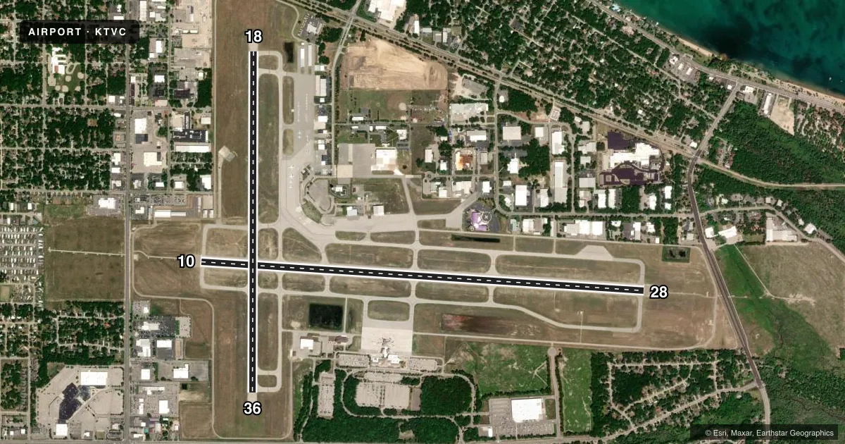
Runways & pattern
Full pagePattern entry · RWY 18
LEFT TRAFFIC| Runway | Heading (°M) | Length | Surface | Traffic |
|---|---|---|---|---|
| 10/28 | 89° / 269° | 7,016 ft | ASPH | Standard L |
| 18/36Favored | 175° / 355° | 5,378 ft | ASPH | Standard L |
Runway end performance
| End | TORA | TODA | ASDA | LDA | VGSI | Approach lights | Obstruction |
|---|---|---|---|---|---|---|---|
| 10 | 7,016' | 7,016' | 7,016' | 7,016' | PAPI 4-box left(3°) | MALSR | 80', tree, 3209' from thr, 187' R of cntrln, slope 37 |
| 28 | 7,016' | 7,016' | 7,016' | 7,016' | PAPI 4-box left(3°) | MALSR | 452', tower, 16493' from thr, 2359' R of cntrln, slope 36 |
| 18 | 5,378' | 5,378' | 5,108' | 4,838' | VASI 4-box left(3°) | — | 70', tree, 1199' from thr, 148' R of cntrln, slope 14 |
| 36 | 5,378' | 5,378' | 5,108' | 5,108' | VASI 4-box left(3.5°) | — | 14', fence, 769' from thr, 0' R of cntrln, slope 40 |
Declared distances in feet. TORA = takeoff run available, TODA = takeoff distance, ASDA = accelerate-stop, LDA = landing distance.
Airport sketch
Runways drawn to scale from FAA survey coordinates, rendered over satellite imagery. Not for navigation.
Approaches & charts
ILS · 2
Services on the field
Fuel grades, oxygen, maintenance, ramp storage and lighting — as declared to the FAA by the airport operator.
Fuel & services
- Fuel
- 100LLA+
- Airframe repair
- Major
- Power plant repair
- Major
- Other services
- AFRT,AGRI,AMB,AVNCS,CARGO,CHTR,INSTR,RNTL
Ramp & ground
- Transient storage
- Tie-down
- Hangar
- Landing fee
- Yes
- Customs
- Not available
- Lighting schedule
- SEE RMK
- Beacon schedule
- SS-SR
- Beacon
- White / Green (civil land)(WG)
- Wind indicator
- Lighted
- Segmented circle
- Yes
Fuel & FBOs
Cheapest 100LL and Jet A on the field and nearby. Always confirm with the FBO before taxi.
Airport notes
Surface conditions, obstructions, local procedures, lighting outages and other notes published with each FAA cycle.
General notes
- BIRDS ON AND INVOF ARPT.
- SNOW REMOVAL OPNS IN PROGRESS WINTER MONTHS; SNOW COMMAND WILL BE MONITORING CTAF DURING NON-ATCT HOURS. ACFT LNDG/DEPARTING TVC SHOULD ANNOUNCE THEIR INTENTIONS ON CTAF WHEN ATCT CLSD.
- TWY C-2/C-3 EAST OF TWY C NOT AVBL TO ACR ACFT.
- FLIGHT CREWS SHOULD READ BACK ALL ADZY INFO PRVDD BY SNOW COMMAND.
- ARPT SFC COND UNMON BTN 0100 - 0400.
- USCG - PPR CTC TRAVERSE CITY FM 21 PRIMARY, 345.0 SECONDARY 15 MINS PRIOR TO ENTERING CG RAMP.
- PARASAILING OPNS 1.5 NM NORTHEAST OF ARPT FROM MEMORIAL DAY TO LABOR DAY 600 FT AGL FROM SR-SS DAILY.
- ALL TSNT ACFT CHRGD LDG, OVNGT RAMP PRKG FEE EXC MIL.
- FOR CD WHEN ATCT IS CLSD CTC FSS VIA RCO, IF UNA CTC MINNEAPOLIS ARTCC AT 651-463-5588.
- COLD TEMPERATURE AIRPORT. ALTITUDE CORRECTION REQUIRED AT OR BELOW -21C.
- 48 HR PPR FOR UNSKED ACR OPS GTR THAN 100000 LB. PPR FOR ACFT OPS WITH WINGSPAN GTR THAN 118 FT. PPR FOR ACFT OPS GTR THAN 12500 LB FOR TWY J & EAST RAMP. TWY C-2/C-3 EAST OF TWY C NOT AVBL TO ACR ACFT. PPR FOR ACFT OPS GTR THAN 60000 LB ON NORTH RAMP. NORTH RAMP CLSD TO ACFT OPS GTR THAN 100000 LB. NO GA ACFT ON THE ACR RAMP. NO ACFT WITH WINGSPAN GTR THAN 40 FT BTN GA RAMP & SOUTH RAMP. PUSHBACK ADZYS ON THE TRML RAMP ARE NOT PRVDD BY ATC. DIVERTING NON-BASED ACR ACFT CTC ARPT OPS AT 231-313-0928 PRIOR TO DIVERTING. NO CUST SVC AVBL.
Lighting notes
- WHEN ATCT CLSD ACTVT MALSR RWY 10 & 28; HIRL RWY 10/28; MIRL RWY 18/36 - CTAF. PAPI RWY 10 & 28; VASI RWY 18 & 36 OPR CONSLY.
Fuel notes
- 100LL100LL SELF SVC FUEL AVBL WITH CREDIT CARD DURG FBO HRS ONLY.
Runway surface & condition
- 10/28PCR VALUE: 470/F/B/X/T
- 18/36PCR VALUE: 310/F/B/X/T
Approach & departure obstructions
- 18DTHR APCH SLOPE 19:1.
Other notes
- 48 HR PPR FOR UNSKED ACR OPS WITH OVER 30 PSGR SEATS - CALL AMGR.
- 1DURG HRS WHEN ARPT IS UNATNDD CALL ARPT OPNS 231-313-0928. FOR FBO HRS OF OPS CALL 231-929-1126.
VFR map & nearby airports
VFR sectional. Tap any ICAO chip to open that airport.
Key facts · KTVC
Answer card- ICAO
- KTVC
- Name
- CHERRY CAPITAL
- Location
- TRAVERSE CITY, MICHIGAN
- Elevation
- 623.9 ft MSL
- Traffic pattern altitude
- 1,623.9 ft MSL (1,000 AGL)
- Control tower
- Towered · 0700 - 2100 EST; 0700 - 2200 EDT
- Total runways
- 2
- Longest runway
- 10/28 · 7,016 ft
- Published ILS approaches
- 2
- Published frequencies
- 7
- Magnetic variation
- 5°
- Current flight rules
- VFR
- Current wind
- 220° at 4 kt
- Favored runway now
- RWY 18
Cherry Capital Airport is in Traverse City, Michigan. The field elevation is 623.9 ft MSL. KTVC has 2 asphalt runways. The longest is runway 10/28 at 7,016 ft. The airport has an operating control tower. Tower hours are 0700 to 2100 EST and 0700 to 2200 EDT.
KTVC has 2 ILS approaches. They are on runway ends 10 and 28. Pattern altitude is not published. Use 1,000 ft AGL for light piston traffic unless ATC or local procedures say otherwise. Avflight Traverse City is on the field. It carries 100LL, Jet A and Jet A Prist. 100LL self-serve fuel is available with credit card during FBO hours only.
First-time arrivals should plan for winter snow operations, birds in the area and cold weather performance. Snow command monitors CTAF when the tower is closed. Pilots should announce intentions on CTAF during non-tower hours. Read back any advisory information from snow command. The airport is a cold temperature airport. Altitude correction is required at or below minus 21 degrees Celsius. Published remarks also note that some ramp and taxiway areas have aircraft size and weight limits. Check the current FAA Chart Supplement and call the airport operator if your aircraft is large, heavy, or unusual for the field.