METAR & TAF Y88
Y88 does not publish a METAR.
Showing the nearest reporting station: KTVC (CHERRY CAPITAL) · 11.1 NM away. Conditions at Y88 may differ.
METAR · KTVC
Observed 08:53Z
KTVC 240853Z AUTO 00000KT 10SM CLR 13/11 A3008 RMK AO2 SLP186 T01280106 56015
- Wind
- 000° @ 0 kt
- Visibility
- 10 SM
- Temp / Dew
- 13°C / 11°C
- Altimeter
- 30.08 inHg
- Clouds
- CLR
- Density alt
- 635 ft
- Ceiling
- Unlimited
- Rules
- VFR
Airport info & contacts
Manager on record, flight service, ARTCC, attendance schedule and pattern altitude — published by the FAA and refreshed every 28 days.
Location
- From city
- 3 NM S
- VFR sectional
- GREEN BAY
- ARTCC
- ZMP · MINNEAPOLIS
- NOTAM facility
- LAN (NOTAM-D)
Airport manager
- Name
- JIM ANDERSON
- Phone
- 231-409-7149
- Address
- 12012 S ELK RUN, TRAVERSE CITY MI 49684-7703
Flight service · Hours
- FSS LAN
- LANSING1-800-WX-BRIEF
- Attendance
- Unattended
Frequencies
Tap any row to copy the frequency to your clipboard.
Runways & pattern
Full pagePattern entry · RWY 05
LEFT TRAFFIC| Runway | Heading (°M) | Length | Surface | Traffic |
|---|---|---|---|---|
| 05/23 | 50° / 230° | 2,800 ft | TURF | Standard L |
| 16/34 | 163° / 343° | 1,700 ft | TURF | Standard L |
Runway end performance
| End | TORA | TODA | ASDA | LDA | VGSI | Approach lights | Obstruction |
|---|---|---|---|---|---|---|---|
| 05 | — | — | — | — | — | — | 63', trees, 50' from thr, 130' R of cntrln, slope 1 |
| 23 | — | — | — | — | — | — | 65', trees, 120' from thr, 140' R of cntrln, slope 1 |
| 16 | — | — | — | — | — | — | 70', trees, 950' from thr, 80' R of cntrln, slope 13 |
| 34 | — | — | — | — | — | — | 70', trees, 750' from thr, 85' R of cntrln, slope 10 |
Declared distances in feet. TORA = takeoff run available, TODA = takeoff distance, ASDA = accelerate-stop, LDA = landing distance.
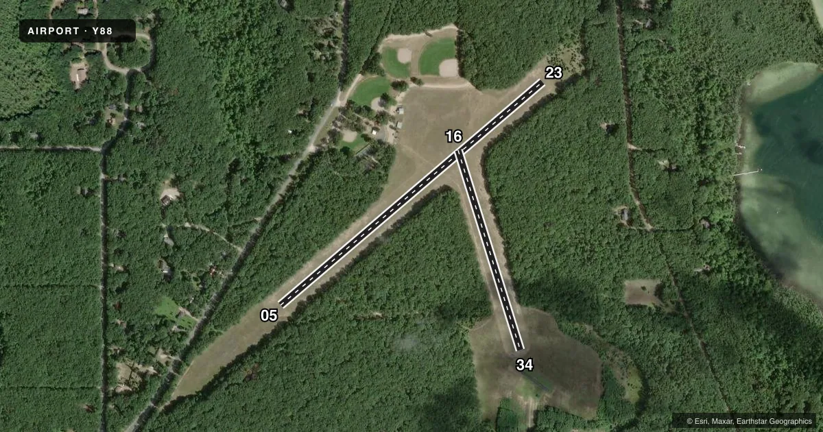
Airport sketch
Runways drawn to scale from FAA survey coordinates, rendered over satellite imagery. Not for navigation.
Approaches & charts
Services on the field
Fuel grades, oxygen, maintenance, ramp storage and lighting — as declared to the FAA by the airport operator.
Fuel & services
- Fuel
- Not available
- Oxygen (bottled)
- Not available
- Oxygen (bulk)
- Not available
- Airframe repair
- Not available
- Power plant repair
- Not available
Ramp & ground
- Transient storage
- Tie-down
- Landing fee
- No fee published
- Wind indicator
- Yes
- Segmented circle
- Yes
Fuel & FBOs
Cheapest 100LL and Jet A on the field and nearby. Always confirm with the FBO before taxi.
Airport notes
Surface conditions, obstructions, local procedures, lighting outages and other notes published with each FAA cycle.
General notes
- NOISE SENSITIVE AREA 1 NM NORTH OF ARPT.
- 460 FT ANT 2 NM NORTH OF ARPT.
- UAS OPRG AREA SOUTH OF RWY 34 DEFINED BY MOWED X SHAPE.
- ADMIN BLDG ACES: PRESS V, THEN III & II SIMUL, THEN I.
- NO SNOW REMOVAL.
- FOR CD CTC MINNEAPOLIS ARTCC AT 651-463-5588.
Runway surface & condition
- 16/34CLSD WHEN ATHLETIC FLDS IN USE ON NORTH END EXTDD CNTRLN.
Approach & departure obstructions
- 05RWY & DTHR MKD WITH 3 FT YELLOW CONES.
- 16RWY & DTHR MKD WITH 3 FT YELLOW CONES.
- 23RWY & DTHR MKD WITH 3 FT YELLOW CONES.
- 34RWY & DTHR MKD WITH 3 FT YELLOW CONES.
- 05APCH SLP 7:1 TO DTHR DUE TO 63 FT TREE, 450 FT DIST, 130 FT L.
- 16APCH SLP 16:1 TO DTHR DUE TO 70 FT TREE, 1126 FT DIST, 80 FT L.
- 23APCH SLP 13:1 TO DTHR DUE TO 65 FT TREE, 900 FT DIST, 140 FT R.
- 34APCH SLP 16:1 TO DTHR DUE TO 70 FT TREE, 1152 FT DIST, 85 FT L/R.
Other notes
- ESTABD BFR 1959.
- MANAGERCELL.
- OWNEREXTN 113.
VFR map & nearby airports
VFR sectional. Tap any ICAO chip to open that airport.
Key facts · Y88
Answer card- ICAO
- Y88
- Name
- GREEN LAKE
- Location
- INTERLOCHEN, MICHIGAN
- Elevation
- 866 ft MSL
- Traffic pattern altitude
- 1,866 ft MSL (1,000 AGL)
- Control tower
- Non-towered (use CTAF)
- Total runways
- 2
- Longest runway
- 05/23 · 2,800 ft
- Published ILS approaches
- 0
- Published frequencies
- 1
- Magnetic variation
- –
- Current flight rules
- VFR
- Current wind
- 000° at 0 kt
- Favored runway now
- –
Green Lake Airport (Y88) sits in Interlochen, Michigan. The field elevation is 866 ft MSL. It has two turf runways. The longest is runway 05/23 at 2,800 ft. Runway 16/34 is 1,700 ft. This is an uncontrolled airport with CTAF 122.9. No ILS approaches are published.
The pattern altitude is not published. Use 1,000 ft AGL for light piston operations unless the current Chart Supplement says otherwise. Published remarks matter here. There is a 460 ft antenna 2 NM north of the airport. The Chart Supplement also notes displaced threshold markings with 3 ft yellow cones on runways 16 and 23. Approach slopes are steep to the displaced thresholds because of trees near both ends. No snow removal is provided.
There are no on-field FBOs listed. Plan on self-sufficiency and verify services with the airport operator before you go. The airport has been established since before 1959. There is also a UAS operating area south of runway 34, marked by a mowed X shape. For clearance delivery, contact Minneapolis ARTCC at 651-463-5588. First-time visitors should pay close attention to the turf surface. They should also watch the tree obstructions and the lack of tower service.