METAR & TAF KHTL
Current METAR
Observed 02:00Z
KHTL 280200Z AUTO 25004KT 6SM -TSRA BKN030 BKN036 OVC065 24/20 A2970 RMK AO2 LTG DSNT ALQDS RAB0154 TSB0154 PRESRR P0001 T02390200
- Wind
- 250° @ 4 kt
- Visibility
- 6 SM
- Temp / Dew
- 24°C / 20°C
- Altimeter
- 29.70 inHg
- Clouds
- OVC
- Density alt
- 2,778 ft
- Ceiling
- 3,000 ft AGL
- Rules
- MVFR
Airport info & contacts
Manager on record, flight service, ARTCC, attendance schedule and pattern altitude — published by the FAA and refreshed every 28 days.
Location
- From city
- 5 NM NE
- VFR sectional
- LAKE HURON
- ARTCC
- ZMP · MINNEAPOLIS
- NOTAM facility
- HTL (NOTAM-D)
Airport manager
- Name
- ERIC J JAROCH
- Phone
- 989-366-7660
- Address
- 5220 E HOUGHTON LAKE DR, HOUGHTON LAKE MI 48629-8313
Flight service · Hours
- FSS LAN
- LANSING1-800-WX-BRIEF
- Attendance
- 0900-1700
Frequencies
Tap any row to copy the frequency to your clipboard.
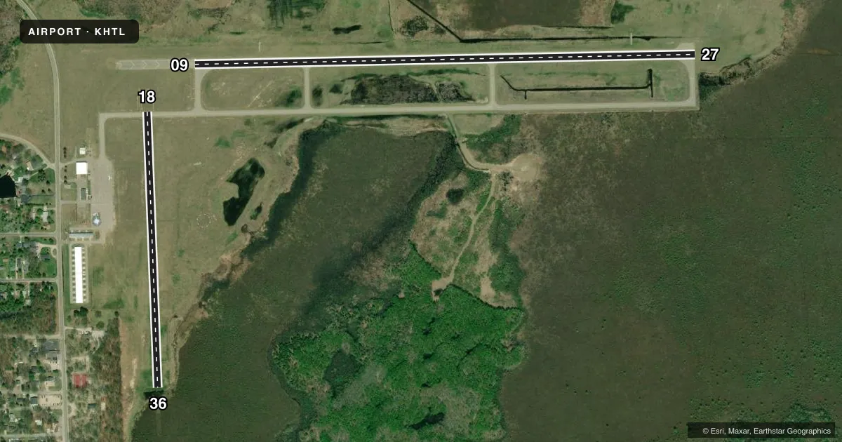
Runways & pattern
Full pagePattern entry · RWY 27
LEFT TRAFFIC| Runway | Heading (°M) | Length | Surface | Traffic |
|---|---|---|---|---|
| 09/27Favored | 84° / 264° | 4,000 ft | ASPH | Standard L |
| 18/36 | 173° / 353° | 2,200 ft | TURF | Standard L |
Runway end performance
| End | TORA | TODA | ASDA | LDA | VGSI | Approach lights | Obstruction |
|---|---|---|---|---|---|---|---|
| 09 | — | — | — | — | PAPI 4-box left(3.5°) | — | — |
| 27 | — | — | — | — | PAPI 4-box right(3.5°) | — | — |
| 18 | — | — | — | — | — | — | 107', tree, 1815' from thr, 324' R of cntrln, slope 16 |
| 36 | — | — | — | — | — | — | 6', brush, 20' from thr, 88' R of cntrln, slope 3 |
Declared distances in feet. TORA = takeoff run available, TODA = takeoff distance, ASDA = accelerate-stop, LDA = landing distance.
Airport sketch
Runways drawn to scale from FAA survey coordinates, rendered over satellite imagery. Not for navigation.
Approaches & charts
Services on the field
Fuel grades, oxygen, maintenance, ramp storage and lighting — as declared to the FAA by the airport operator.
Fuel & services
- Fuel
- 100LL
- Oxygen (bottled)
- Not available
- Oxygen (bulk)
- Not available
- Airframe repair
- Major
- Power plant repair
- Major
- Other services
- INSTR
Ramp & ground
- Transient storage
- Tie-down
- Landing fee
- No fee published
- Customs
- Not available
- Lighting schedule
- SEE RMK
- Beacon schedule
- SS-SR
- Beacon
- White / Green (civil land)(WG)
- Wind indicator
- Lighted
- Segmented circle
- Yes
Fuel & FBOs
Cheapest 100LL and Jet A on the field and nearby. Always confirm with the FBO before taxi.
Airport notes
Surface conditions, obstructions, local procedures, lighting outages and other notes published with each FAA cycle.
General notes
- DEER, BIRDS, & WILDLIFE ON & INVOF ARPT.
- 2203 FT MSL (883 AGL) TOWER 4.2 NM SW OF ARPT.
- FOR CD CTC MINNEAPOLIS ARTCC AT 651-463-5588.
Lighting notes
- ACTVT OR INCR INTST REIL RWY 09 & 27; PAPI RWY 09 & 27; HIRL RWY 09/27 - CTAF. HIRL RWY 09/27 PRESET LOW INTST DUSK-2100.
Runway surface & condition
- 18/36CLSD WHEN SNOW COVD EXC FOR SKI EQUIPPED ACFT.
Approach & departure obstructions
- 183 FT YELLOW CONES.
- 363 FT YELLOW CONES.
- 36CTLG OBSTN EXCEEDS A 45 DEG SLP. APCH RATIO 3:1 TO DTHR OVR +6 FT BRUSH, 20 FT DIST, 88 FT R.
Other notes
- 1UNATNDD MAJOR HOLS.
- MANAGERCELL 989-390-2398.
VFR map & nearby airports
VFR sectional. Tap any ICAO chip to open that airport.
Key facts · KHTL
Answer card- ICAO
- KHTL
- Name
- ROSCOMMON COUNTY/BLODGETT MEML
- Location
- HOUGHTON LAKE, MICHIGAN
- Elevation
- 1,149.7 ft MSL
- Traffic pattern altitude
- 2,149.7 ft MSL (1,000 AGL)
- Control tower
- Non-towered (use CTAF)
- Total runways
- 2
- Longest runway
- 09/27 · 4,000 ft
- Published ILS approaches
- 0
- Published frequencies
- 2
- Magnetic variation
- 5°
- Current flight rules
- MVFR
- Current wind
- 250° at 4 kt
- Favored runway now
- RWY 27
Roscommon County/Blodgett Memorial Airport sits in Houghton Lake, Michigan. Field elevation is 1,149.7 ft MSL. The airport has two runways. The longest is runway 09/27 at 4,000 ft asphalt. Runway 18/36 is 2,200 ft turf. There is no control tower. CTAF and UNICOM are both 122.8. Pattern altitude is not published, so use the standard 1,000 ft AGL for light piston traffic unless the current Chart Supplement says otherwise.
No ILS approaches are published here. The field uses CTAF for lighting activation. Runway 09/27 has REILs, PAPI and high intensity runway lights. The high intensity lights are preset to low intensity from dusk to 2100. Runway 18/36 is closed when snow covered except for ski equipped aircraft. Three foot yellow cones mark the ends of runways 18 and 36. Deer and large birds are reported on and near the airport, so keep a sharp scan on arrival and departure.
The on-field FBO is Roscommon County-Blodgett Memorial Airport. It carries AVGAS 100LL. For clearance delivery, the published contact is Minneapolis ARTCC. A tower is listed 4.2 NM southwest of the airport at 2,203 ft MSL. Verify any local procedures with the current Chart Supplement before you go.