METAR & TAF 4M0
4M0 does not publish a METAR.
Showing the nearest reporting station: KFKS (FRANKFORT DOW MEML FLD) · 13.0 NM away. Conditions at 4M0 may differ.
METAR · KFKS
Observed 17:15Z
KFKS 271715Z AUTO 18007KT 6SM -RA BR OVC110 20/19 A2972 RMK AO2 PRESFR
- Wind
- 180° @ 7 kt
- Visibility
- 6 SM
- Temp / Dew
- 20°C / 19°C
- Altimeter
- 29.72 inHg
- Clouds
- OVC
- Density alt
- 1,865 ft
- Ceiling
- 11,000 ft AGL
- Rules
- VFR
Airport info & contacts
Manager on record, flight service, ARTCC, attendance schedule and pattern altitude — published by the FAA and refreshed every 28 days.
Location
- From city
- 12 NM W
- VFR sectional
- GREEN BAY
- ARTCC
- ZMP · MINNEAPOLIS
- NOTAM facility
- LAN (NOTAM-D)
Airport manager
- Name
- SHANE GRAY
- Phone
- 231-640-9756
- Address
- 4449 MAPLE CITY HWY, INTERLOCHEN MI 49643-9645
Flight service · Hours
- FSS LAN
- LANSING1-800-WX-BRIEF
- Attendance
- Unattended
Frequencies
Tap any row to copy the frequency to your clipboard.
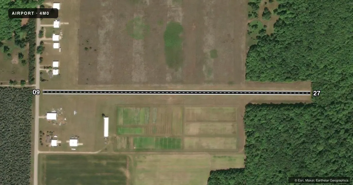
Runways & pattern
Full pagePattern entry · RWY 09
LEFT TRAFFICRunway end performance
| End | TORA | TODA | ASDA | LDA | VGSI | Approach lights | Obstruction |
|---|---|---|---|---|---|---|---|
| 09 | — | — | — | — | — | — | 14', road, 44' from thr, 129' R of cntrln, slope 3 |
| 27 | — | — | — | — | — | — | 75', trees, 0' from thr, 125' R of cntrln, slope 0 |
Declared distances in feet. TORA = takeoff run available, TODA = takeoff distance, ASDA = accelerate-stop, LDA = landing distance.
Airport sketch
Runways drawn to scale from FAA survey coordinates, rendered over satellite imagery. Not for navigation.
Approaches & charts
Services on the field
Fuel grades, oxygen, maintenance, ramp storage and lighting — as declared to the FAA by the airport operator.
Fuel & services
- Fuel
- Not available
Ramp & ground
- Transient storage
- Tie-down
- Wind indicator
- Yes
- Segmented circle
- No
Fuel & FBOs
Cheapest 100LL and Jet A on the field and nearby. Always confirm with the FBO before taxi.
Airport notes
Surface conditions, obstructions, local procedures, lighting outages and other notes published with each FAA cycle.
General notes
- FOR CD CTC MINNEAPOLIS ARTCC AT 651-463-5588.
- EAST 600 FT OF RWY 09/27 SRNDD BY 75 FT TREES, 125 FT L/R OF CNTRLN.
- ARPT CLSD OCT-MAY & WHEN SNOW COVD EXC FOR SKI EQUIPPED ACFT.
- 8 FT FENCE, 110 FT SOUTH OF RWY 09/27 CNTRLN, 1000 FT LEN.
- RWY 27 DTHR 1337 FT, EXTDS BYD RWY MIDPT.
- DEER, BIRDS, & WILDLIFE ON & INVOF ARPT.
Approach & departure obstructions
- 09RWY & DTHR MKD WITH 3 FT YELLOW CONES.
- 27RWY & DTHR MKD WITH 3 FT YELLOW CONES.
- 09APCH RATIO 20:1 TO DTHR BASED ON STRAIGHT OUT OVR 92 FT TREES, 1840 FT DIST.
- 27APCH RATIO 20:1 TO DTHR BASED ON STRAIGHT OUT OVR 88 FT TREES, 1760 FT DIST.
- 09ALSO 30 FT TREES, 100 FT DIST, 135 FT L/R.
Other notes
- SEE AIRSPACE CASE 95-AGL-642-NRA. ALSO REFER TO 93-AGL-733-NRA AND 91-AGL-628-NRA.
- ROPES NOT PRVDD.
- MANAGERARPT PHYS ADS: 4411 MAPLE CITY HWY, INTERLOCHEN, MI 49643.
- MANAGERSHANECGRAY@YAHOO.COM.
VFR map & nearby airports
VFR sectional. Tap any ICAO chip to open that airport.
Key facts · 4M0
Answer card- ICAO
- 4M0
- Name
- LAKE ANN AIRWAY ESTATES
- Location
- TRAVERSE CITY, MICHIGAN
- Elevation
- 820 ft MSL
- Traffic pattern altitude
- 1,820 ft MSL (1,000 AGL)
- Control tower
- Non-towered (use CTAF)
- Total runways
- 1
- Longest runway
- 09/27 · 2,537 ft
- Published ILS approaches
- 0
- Published frequencies
- 1
- Magnetic variation
- –
- Current flight rules
- VFR
- Current wind
- 180° at 7 kt
- Favored runway now
- RWY 09
Lake Ann Airway Estates (4M0) is in Traverse City, Michigan. Field elevation is 820 ft MSL. The airport has one runway. The longest runway is 09/27 at 2,537 ft on turf. There is no control tower. CTAF is 122.9. No ILS approaches are published.
The pattern altitude is not published. Use the standard 1,000 ft AGL for light piston operations unless the current FAA Chart Supplement says otherwise. There are no on-field FBOs listed. Check with the airport operator or the FBO directly by phone before arrival if you need current services.
This field has some important operating notes. The airport is closed from October through May. It is also closed when snow covered except for ski-equipped aircraft. Runway 27 has a displaced threshold of 1,337 ft. The east 600 ft of the runway is lined by 75 ft trees close to the centerline. The published approach notes also call out 88 ft trees on the 09 side. They also call out 92 ft trees on the 27 side. Deer, birds and other wildlife are reported on and near the airport. For clearance delivery, contact Minneapolis ARTCC at 651-463-5588. If you are planning a first visit, treat this as a short turf strip with significant tree and seasonal limitations. Verify current status before you go.