METAR & TAF KCAD
Current METAR
Observed 21:55Z
KCAD 272155Z AUTO 18009KT 10SM SCT031 OVC095 27/19 A2973 RMK AO2
- Wind
- 180° @ 9 kt
- Visibility
- 10 SM
- Temp / Dew
- 27°C / 19°C
- Altimeter
- 29.73 inHg
- Clouds
- OVC
- Density alt
- 3,296 ft
- Ceiling
- 9,500 ft AGL
- Rules
- VFR
Airport info & contacts
Manager on record, flight service, ARTCC, attendance schedule and pattern altitude — published by the FAA and refreshed every 28 days.
Location
- From city
- 2 NM NNW
- VFR sectional
- GREEN BAY
- ARTCC
- ZMP · MINNEAPOLIS
- NOTAM facility
- CAD (NOTAM-D)
Airport manager
- Name
- KEITH NEWELL
- Phone
- 231-878-5178
- Address
- 8040 E 34 RD, CADILLAC MI 49601-9015
Flight service · Hours
- FSS LAN
- LANSING1-800-WX-BRIEF
- Attendance
- MON-FRI · 0700-1700
- MAY-SEP · SAT · 0800-1200
Frequencies
Tap any row to copy the frequency to your clipboard.
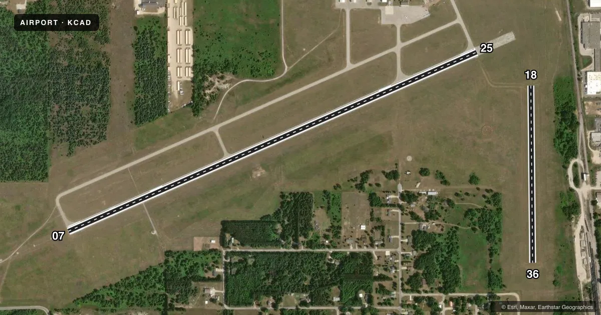
Runways & pattern
Full pagePattern entry · RWY 18
LEFT TRAFFIC| Runway | Heading (°M) | Length | Surface | Traffic |
|---|---|---|---|---|
| 07/25 | 62° / 242° | 5,001 ft | ASPH | Standard L |
| 18/36Favored | 175° / 355° | 1,986 ft | TURF | Standard L |
Runway end performance
| End | TORA | TODA | ASDA | LDA | VGSI | Approach lights | Obstruction |
|---|---|---|---|---|---|---|---|
| 07 | — | — | — | — | VASI 4-box left(3°) | MALSF | 42', tree, 901' from thr, 372' R of cntrln, slope 16 |
| 25 | — | — | — | — | PAPI 4-box left(3°) | — | 37', pole, 1372' from thr, 626' R of cntrln, slope 31 |
| 36 | — | — | — | — | — | — | 51', tree, 1153' from thr, 237' R of cntrln, slope 18 |
Declared distances in feet. TORA = takeoff run available, TODA = takeoff distance, ASDA = accelerate-stop, LDA = landing distance.
Airport sketch
Runways drawn to scale from FAA survey coordinates, rendered over satellite imagery. Not for navigation.
Approaches & charts
ILS · 1
Services on the field
Fuel grades, oxygen, maintenance, ramp storage and lighting — as declared to the FAA by the airport operator.
Fuel & services
- Fuel
- 100LLA
- Airframe repair
- Major
- Power plant repair
- Major
- Other services
- GLD,INSTR,TOW
Ramp & ground
- Transient storage
- Tie-down
- Hangar
- Landing fee
- No fee published
- Customs
- Not available
- Lighting schedule
- SEE RMK
- Beacon schedule
- SS-SR
- Beacon
- White / Green (civil land)(WG)
- Wind indicator
- Lighted
- Segmented circle
- Yes
Fuel & FBOs
Cheapest 100LL and Jet A on the field and nearby. Always confirm with the FBO before taxi.
Airport notes
Surface conditions, obstructions, local procedures, lighting outages and other notes published with each FAA cycle.
General notes
- DEER & LRG BIRDS ON & INVOF ARPT.
- ADMIN BLDG EAST DOOR ACES 5-3-2-1.
- GLDR & ULTRALIGHT ACT ON & INVOF ARPT APR-OCT.
- FOR CD CTC MINNEAPOLIS ARTCC AT 651-463-5588.
Lighting notes
- ACTVT MALSF RWY 07; REIL RWY 07 & 25; VASI RWY 07; PAPI RWY 25; HIRL RWY 07/25 - CTAF.
Fuel notes
- 100LLAVBL H24 SELF SVC.
Runway surface & condition
- 18/36CLSD DEC-MAR & WHEN SNOW COVD EXC FOR SKI EQUIPPED ACFT.
Approach & departure obstructions
- 183 FT YELLOW CONES.
- 363 FT YELLOW CONES.
Other notes
- LDG FEE FOR COML OPS WAIVED WITH MNM FUEL PURCHASE.
- 4FOR AFT HRS ATNDNC CALL 231-779-9211 SUBJ CALL-IN FEE. UNATNDD MAJOR HOLS.
- MANAGERCELL.
VFR map & nearby airports
VFR sectional. Tap any ICAO chip to open that airport.
Key facts · KCAD
Answer card- ICAO
- KCAD
- Name
- WEXFORD COUNTY
- Location
- CADILLAC, MICHIGAN
- Elevation
- 1,306.5 ft MSL
- Traffic pattern altitude
- 2,306.5 ft MSL (1,000 AGL)
- Control tower
- Non-towered (use CTAF)
- Total runways
- 2
- Longest runway
- 07/25 · 5,001 ft
- Published ILS approaches
- 1
- Published frequencies
- 2
- Magnetic variation
- 4°
- Current flight rules
- VFR
- Current wind
- 180° at 9 kt
- Favored runway now
- RWY 18
Wexford County Airport is in Cadillac, Michigan. The field elevation is 1,306.5 ft MSL. It has two runways. The longest is Runway 07/25 at 5,001 ft asphalt. Runway 18/36 is 1,986 ft turf. There is no control tower. CTAF and UNICOM are both 122.8. One ILS approach is published for Runway 07.
Pattern altitude is not published. Use the standard 1,000 ft AGL for light piston traffic unless ATC or the Chart Supplement says otherwise. The on-field FBO is Wexford County Airport. It carries 100LL and Jet A Prist. 100LL is available 24 hours self serve. The published remarks also note after-hours attendance by phone, subject to a call-in fee. The airport is not unattended on major holidays.
This is a field where runway condition matters. Runway 18/36 is closed December through March. It is also closed when snow covered except for ski equipped aircraft. Deer and large birds are reported on and near the airport. Glider and ultralight activity occurs from April through October. Runway 07 has MALSR, REIL and VASI. Runway 25 has REIL, PAPI and high intensity runway lighting. For clearance delivery, contact Minneapolis ARTCC. If you are new to the airport, plan for the lighting setup on 07/25 and verify current conditions before you launch.