METAR & TAF 8D4
Current METAR
Observed 16:15Z
K8D4 271615Z AUTO 22011KT 10SM CLR 27/21 A2976 RMK AO2 PRESFR
- Wind
- 220° @ 11 kt
- Visibility
- 10 SM
- Temp / Dew
- 27°C / 21°C
- Altimeter
- 29.76 inHg
- Clouds
- CLR
- Density alt
- 2,599 ft
- Ceiling
- Unlimited
- Rules
- VFR
Airport info & contacts
Manager on record, flight service, ARTCC, attendance schedule and pattern altitude — published by the FAA and refreshed every 28 days.
Location
- From city
- 2 NM SE
- VFR sectional
- CHICAGO
- ARTCC
- ZAU · CHICAGO
- NOTAM facility
- 8D4 (NOTAM-D)
Airport manager
- Name
- MICHAEL KRZCIOK
- Phone
- 616-240-4295
- Address
- 9100 VINTON AVE NW, SPARTA MI 49345-9423
Flight service · Hours
- FSS LAN
- LANSING1-800-WX-BRIEF
- Attendance
- MON-FRI · 0800-1700
Frequencies
Tap any row to copy the frequency to your clipboard.
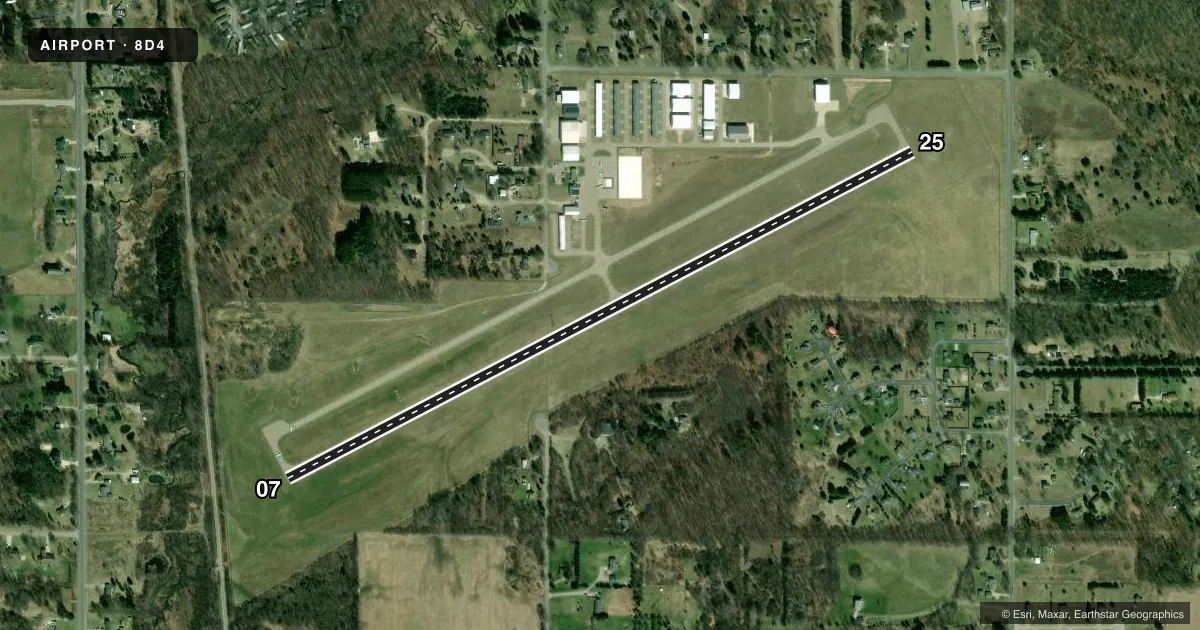
Runways & pattern
Full pagePattern entry · RWY 25
LEFT TRAFFICRunway end performance
| End | TORA | TODA | ASDA | LDA | VGSI | Approach lights | Obstruction |
|---|---|---|---|---|---|---|---|
| 07 | — | — | — | — | PAPI 4-box left(3.5°) | — | 27', tree, 471' from thr, 166' R of cntrln, slope 10 |
| 25 | — | — | — | — | PAPI 4-box right(3.5°) | — | 34', tree, 716' from thr, 342' R of cntrln, slope 15 |
Declared distances in feet. TORA = takeoff run available, TODA = takeoff distance, ASDA = accelerate-stop, LDA = landing distance.
Airport sketch
Runways drawn to scale from FAA survey coordinates, rendered over satellite imagery. Not for navigation.
Approaches & charts
Services on the field
Fuel grades, oxygen, maintenance, ramp storage and lighting — as declared to the FAA by the airport operator.
Fuel & services
- Fuel
- 100LLA+MOGAS
- Oxygen (bottled)
- Not available
- Oxygen (bulk)
- Not available
- Airframe repair
- Minor
- Power plant repair
- Minor
- Other services
- AVNCS,INSTR,RNTL
Ramp & ground
- Transient storage
- Tie-down
- Hangar
- Landing fee
- No fee published
- Customs
- Not available
- Lighting schedule
- SEE RMK
- Beacon schedule
- SS-SR
- Beacon
- White / Green (civil land)(WG)
- Wind indicator
- Lighted
- Segmented circle
- Yes
Fuel & FBOs
Cheapest 100LL and Jet A on the field and nearby. Always confirm with the FBO before taxi.
Airport notes
Surface conditions, obstructions, local procedures, lighting outages and other notes published with each FAA cycle.
General notes
- DEER & LRG BIRDS ON & INVOF ARPT.
- ADMIN BLDG ACES: 5-3-2-1.
- FOR CD CTC GREAT LAKES APCH AT 269-459-3344, WHEN APCH CLSD CTC CHICAGO ARTCC AT 630-906-8921.
Lighting notes
- ACTVT REIL RWY 07 & 25; PAPI RWY 07 & 25; MIRL RWY 07/25 - CTAF.
Fuel notes
- 100LL100LL & JET A+ AVBL H24 SELF SVC VIA CREDIT CARD.
Other notes
- RPRS AVBL ON CALL 616-706-4421.
- MANAGERCELL 616-240-4295.
VFR map & nearby airports
VFR sectional. Tap any ICAO chip to open that airport.
Key facts · 8D4
Answer card- ICAO
- 8D4
- Name
- PAUL C MILLER/SPARTA
- Location
- SPARTA, MICHIGAN
- Elevation
- 774.7 ft MSL
- Traffic pattern altitude
- 1,774.7 ft MSL (1,000 AGL)
- Control tower
- Non-towered (use CTAF)
- Total runways
- 1
- Longest runway
- 07/25 · 4,033 ft
- Published ILS approaches
- 0
- Published frequencies
- 4
- Magnetic variation
- 4°
- Current flight rules
- VFR
- Current wind
- 220° at 11 kt
- Favored runway now
- RWY 25
PAUL C MILLER/SPARTA (8D4) sits in Sparta, Michigan. The field elevation is 774.7 ft MSL. It has one runway. Runway 07/25 is 4,033 ft long and asphalt. The airport is not towered. Pattern altitude is not published, so use standard traffic pattern planning unless the current Chart Supplement says otherwise.
No ILS approaches are published here. Great Lakes Approach handles the approach side on 124.6 and 257.6. CTAF and UNICOM are both 122.8. For clearance delivery, the published remark says to contact Great Lakes Approach first. If Approach is closed, contact Chicago ARTCC.
Miller-Sparta Airport is the on-field FBO. It carries 100LL, Jet A and mogas. 100LL is available 24 hours a day through self-serve credit card fueling. The runway lighting is pilot-controlled on CTAF. Runway end identifier lights and PAPI are published for both ends of 07/25.
A first-time pilot should plan for wildlife. Deer and large birds are reported on and near the airport. The airport also publishes airframe repair on call. If you need any operational detail beyond these basics, verify it with the current FAA Chart Supplement or call the airport operator before you go.