METAR & TAF 56C
56C does not publish a METAR.
Showing the nearest reporting station: KGRR (GERALD R FORD INTL) · 16.2 NM away. Conditions at 56C may differ.
METAR · KGRR
Observed 12:53Z
KGRR 271253Z 23008KT 1 1/2SM -RA BR BKN006 OVC060 24/24 A2985 RMK AO2 RAB30 SLP102 P0001 T02440239
- Wind
- 230° @ 8 kt
- Visibility
- 0.5 SM
- Temp / Dew
- 24°C / 24°C
- Altimeter
- 29.85 inHg
- Clouds
- OVC
- Density alt
- 2,187 ft
- Ceiling
- 600 ft AGL
- Rules
- LIFR
Airport info & contacts
Manager on record, flight service, ARTCC, attendance schedule and pattern altitude — published by the FAA and refreshed every 28 days.
Location
- From city
- 2 NM SW
- VFR sectional
- CHICAGO
- ARTCC
- ZAU · CHICAGO
- NOTAM facility
- LAN (NOTAM-D)
Airport manager
- Name
- GREG BROWN
- Phone
- 616-813-1988
- Address
- 6199 WHITES BRIDGE RD, BELDING MI 48809
Flight service · Hours
- FSS LAN
- LANSING1-800-WX-BRIEF
- Attendance
- Unattended
Frequencies
Tap any row to copy the frequency to your clipboard.
Runways & pattern
Full pagePattern entry · RWY 25
LEFT TRAFFICRunway end performance
| End | TORA | TODA | ASDA | LDA | VGSI | Approach lights | Obstruction |
|---|---|---|---|---|---|---|---|
| 07 | — | — | — | — | — | — | 60', tree, 68' from thr, 120' R of cntrln, slope 1 |
| 25 | — | — | — | — | — | — | 40', tree, 20' from thr, 105' R of cntrln, slope 0 |
Declared distances in feet. TORA = takeoff run available, TODA = takeoff distance, ASDA = accelerate-stop, LDA = landing distance.
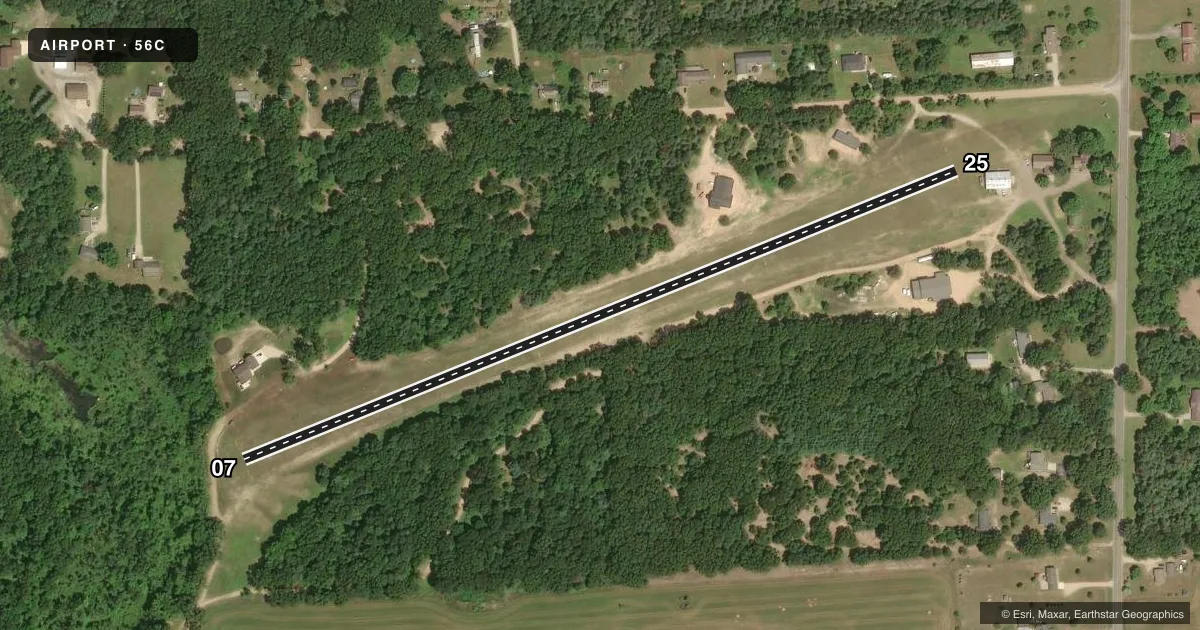
Airport sketch
Runways drawn to scale from FAA survey coordinates, rendered over satellite imagery. Not for navigation.
Approaches & charts
Services on the field
Fuel grades, oxygen, maintenance, ramp storage and lighting — as declared to the FAA by the airport operator.
Fuel & services
- Fuel
- Not available
Ramp & ground
- Transient storage
- Tie-down
- Wind indicator
- Yes
- Segmented circle
- No
Fuel & FBOs
Cheapest 100LL and Jet A on the field and nearby. Always confirm with the FBO before taxi.
Airport notes
Surface conditions, obstructions, local procedures, lighting outages and other notes published with each FAA cycle.
General notes
- FOR CD CTC GREAT LAKES APCH AT 269-459-3344, WHEN APCH CLSD CTC CHICAGO ARTCC AT 630-906-8921.
- RWY 07/25 20-60 FT TREES IN PRIMARY SFC, 80-110 FT FM CNTRLN, BOTH SIDES.
- ARPT CLSD NOV-APR & WHEN SNOW COVD.
Approach & departure obstructions
- 07RWY & DTHR MKD WITH 3 FT YELLOW CONES.
- 25RWY & DTHR MKD WITH 3 FT YELLOW CONES.
- 07APCH RATIO 0:1 TO DTHR OVR 20 FT TREE, 0 FT DIST, 110 FT R.
- 25APCH RATIO 0:1 TO DTHR OVR 40 FT TREE, 5 FT DIST, 110 FT R.
Other notes
- VFR ONLY.
VFR map & nearby airports
VFR sectional. Tap any ICAO chip to open that airport.
Key facts · 56C
Answer card- ICAO
- 56C
- Name
- BOULDER CANYON
- Location
- BELDING, MICHIGAN
- Elevation
- 823 ft MSL
- Traffic pattern altitude
- 1,823 ft MSL (1,000 AGL)
- Control tower
- Non-towered (use CTAF)
- Total runways
- 1
- Longest runway
- 07/25 · 2,200 ft
- Published ILS approaches
- 0
- Published frequencies
- 1
- Magnetic variation
- –
- Current flight rules
- LIFR
- Current wind
- 230° at 8 kt
- Favored runway now
- RWY 25
Boulder Canyon (56C) sits near Belding, Michigan. Field elevation is 823 ft MSL. The airport has one runway. Runway 07/25 is 2,200 ft of turf, so plan for soft-field performance and keep the surface condition in mind before departure. There is no control tower. CTAF is 122.9. No ILS approaches are published.
Pattern altitude is not published. Use the standard 1,000 ft AGL pattern unless the current FAA Chart Supplement or local traffic calls for something different. This field is VFR only. The airport is closed from November through April. It is also closed when snow covered, so seasonal conditions matter here.
There are no on-field FBOs listed. Contact the airport operator directly before arrival if you need current services. Published remarks note yellow cones marking the runway and displaced threshold. They also note tree obstructions near both runway ends. The approach path to the displaced threshold has trees close in the departure area and off to the right, so treat both ends as a short-field, obstacle-aware arrival. For clearance delivery, contact Great Lakes Approach. If approach is closed, contact Chicago ARTCC. Check the current FAA Chart Supplement before flying in.