METAR & TAF 22C
22C does not publish a METAR.
Showing the nearest reporting station: KAMN (GRATIOT COMMUNITY) · 21.8 NM away. Conditions at 22C may differ.
METAR · KAMN
Observed 16:55Z
KAMN 271655Z AUTO 28009KT 10SM CLR 29/19 A2975 RMK AO2 PRESFR
- Wind
- 280° @ 9 kt
- Visibility
- 10 SM
- Temp / Dew
- 29°C / 19°C
- Altimeter
- 29.75 inHg
- Clouds
- CLR
- Density alt
- 2,994 ft
- Ceiling
- Unlimited
- Rules
- VFR
Airport info & contacts
Manager on record, flight service, ARTCC, attendance schedule and pattern altitude — published by the FAA and refreshed every 28 days.
Location
- From city
- 5 NM W
- VFR sectional
- CHICAGO
- ARTCC
- ZAU · CHICAGO
- NOTAM facility
- LAN (NOTAM-D)
Airport manager
- Name
- JOSEPH RODRIGUEZ
- Phone
- 616-835-5338
- Address
- 221 ROYAL DR, STANTON MI 48888-9356
Flight service · Hours
- FSS LAN
- LANSING1-800-WX-BRIEF
- Attendance
- Unattended
Frequencies
Tap any row to copy the frequency to your clipboard.
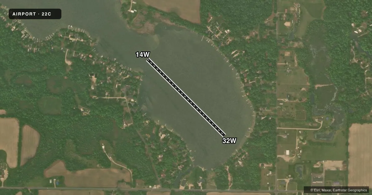
Runways & pattern
Full pagePattern entry · RWY 32W
LEFT TRAFFICAirport sketch
Runways drawn to scale from FAA survey coordinates, rendered over satellite imagery. Not for navigation.
Approaches & charts
Services on the field
Fuel grades, oxygen, maintenance, ramp storage and lighting — as declared to the FAA by the airport operator.
Fuel & services
- Fuel
- Not available
Ramp & ground
- Transient storage
- Tie-down
Fuel & FBOs
Cheapest 100LL and Jet A on the field and nearby. Always confirm with the FBO before taxi.
Airport notes
Surface conditions, obstructions, local procedures, lighting outages and other notes published with each FAA cycle.
General notes
- FOR CD CTC GREAT LAKES APCH AT 269-459-3344, WHEN APCH CLSD CTC CHICAGO ARTCC AT 630-906-8921.
VFR map & nearby airports
VFR sectional. Tap any ICAO chip to open that airport.
Key facts · 22C
Answer card- ICAO
- 22C
- Name
- CLIFFORD LAKE
- Location
- STANTON, MICHIGAN
- Elevation
- 890 ft MSL
- Traffic pattern altitude
- 1,890 ft MSL (1,000 AGL)
- Control tower
- Non-towered (use CTAF)
- Total runways
- 1
- Longest runway
- 14W/32W · 2,000 ft
- Published ILS approaches
- 0
- Published frequencies
- 1
- Magnetic variation
- –
- Current flight rules
- VFR
- Current wind
- 280° at 9 kt
- Favored runway now
- RWY 32W
Clifford Lake (22C) sits near Stanton, Michigan. The field elevation is 890 ft MSL. It has one runway. The longest is 14W/32W, a 2,000 ft water runway with magnetic headings of 135° and 315°. There is no control tower. CTAF is 122.9.
No ILS approaches are published here. The pattern altitude is not published in the facts, so use the standard 1,000 ft AGL only if that matches the current Chart Supplement and local practice. For this field, that puts the pattern at 1,890 ft MSL based on the listed elevation. Check the current Chart Supplement before flight for any updates.
There are no on-field FBOs listed in the facts. Contact the airport operator directly before arrival, or call the field on CTAF for current support. Published remarks say clearance delivery goes through Great Lakes Approach at 269-459-3344. When Approach is closed, contact Chicago ARTCC at 630-906-8921. That is the main operational item to have ready before departure or arrival.