METAR & TAF C61
C61 does not publish a METAR.
Showing the nearest reporting station: KRQB (ROBEN-HOOD) · 21.1 NM away. Conditions at C61 may differ.
METAR · KRQB
Observed 12:35Z
KRQB 271235Z AUTO 24008KT 10SM CLR 24/21 A2981 RMK AO2
- Wind
- 240° @ 8 kt
- Visibility
- 10 SM
- Temp / Dew
- 24°C / 21°C
- Altimeter
- 29.81 inHg
- Clouds
- CLR
- Density alt
- 2,349 ft
- Ceiling
- Unlimited
- Rules
- VFR
Airport info & contacts
Manager on record, flight service, ARTCC, attendance schedule and pattern altitude — published by the FAA and refreshed every 28 days.
Location
- From city
- 2 NM NE
- VFR sectional
- CHICAGO
- ARTCC
- ZAU · CHICAGO
- NOTAM facility
- LAN (NOTAM-D)
Airport manager
- Name
- PATRICK D FASE
- Phone
- 616-304-3056
- Address
- 6104 MARY ANN DR, CORAL MI 49322-9790
Flight service · Hours
- FSS LAN
- LANSING1-800-WX-BRIEF
- Attendance
- Unattended
Frequencies
Tap any row to copy the frequency to your clipboard.
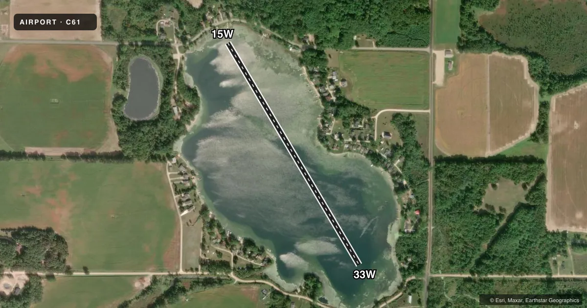
Runways & pattern
Full pagePattern entry · RWY 33W
LEFT TRAFFICAirport sketch
Runways drawn to scale from FAA survey coordinates, rendered over satellite imagery. Not for navigation.
Approaches & charts
Services on the field
Fuel grades, oxygen, maintenance, ramp storage and lighting — as declared to the FAA by the airport operator.
Fuel & services
- Fuel
- Not available
Ramp & ground
- Transient storage
- Tie-down
Fuel & FBOs
Cheapest 100LL and Jet A on the field and nearby. Always confirm with the FBO before taxi.
Airport notes
Surface conditions, obstructions, local procedures, lighting outages and other notes published with each FAA cycle.
General notes
- FOR CD CTC GREAT LAKES APCH AT 269-459-3344, WHEN APCH CLSD CTC CHICAGO ARTCC AT 630-906-8921.
Other notes
- BEACHING & TIE DOWN AREA LCTD AT SW SIDE OF LAKE.
VFR map & nearby airports
VFR sectional. Tap any ICAO chip to open that airport.
Key facts · C61
Answer card- ICAO
- C61
- Name
- WINFIELD LANDING
- Location
- CORAL, MICHIGAN
- Elevation
- 913 ft MSL
- Traffic pattern altitude
- 1,913 ft MSL (1,000 AGL)
- Control tower
- Non-towered (use CTAF)
- Total runways
- 1
- Longest runway
- 15W/33W · 3,000 ft
- Published ILS approaches
- 0
- Published frequencies
- 1
- Magnetic variation
- –
- Current flight rules
- VFR
- Current wind
- 240° at 8 kt
- Favored runway now
- RWY 33W
Winfield Landing (C61) sits in Coral, Michigan. The field elevation is 913 ft MSL. It has one runway. The longest is 15W/33W, a 3,000 ft water runway with magnetic headings 149° and 329°. No tower is listed, so plan on CTAF self-announce work on 122.9.
No ILS approaches are published here. The pattern altitude is not published in the facts, so use the current FAA Chart Supplement before you go. For clearance delivery, contact Great Lakes Approach at 269-459-3344. When Approach is closed, contact Chicago ARTCC at 630-906-8921.
There are no on-field FBOs listed in the facts. Beaching and tie down area is on the southwest side of the lake. That is useful to know before arrival, especially if you are planning a first visit or bringing a floatplane. With a water runway and no tower, expect to manage your own spacing and traffic calls carefully. Check the current FAA Chart Supplement for any published noise or curfew restrictions before flying into the field.