METAR & TAF 35C
35C does not publish a METAR.
Showing the nearest reporting station: KGRR (GERALD R FORD INTL) · 14.9 NM away. Conditions at 35C may differ.
METAR · KGRR
Observed 12:53Z
KGRR 271253Z 23008KT 1 1/2SM -RA BR BKN006 OVC060 24/24 A2985 RMK AO2 RAB30 SLP102 P0001 T02440239
- Wind
- 230° @ 8 kt
- Visibility
- 0.5 SM
- Temp / Dew
- 24°C / 24°C
- Altimeter
- 29.85 inHg
- Clouds
- OVC
- Density alt
- 2,270 ft
- Ceiling
- 600 ft AGL
- Rules
- LIFR
Airport info & contacts
Manager on record, flight service, ARTCC, attendance schedule and pattern altitude — published by the FAA and refreshed every 28 days.
Location
- From city
- 2 NM ENE
- VFR sectional
- CHICAGO
- ARTCC
- ZAU · CHICAGO
- NOTAM facility
- LAN (NOTAM-D)
Airport manager
- Name
- TERRY FINGER
- Phone
- 616-901-5269
- Address
- 6530 11 MILE RD NE, ROCKFORD MI 49341-9504
Flight service · Hours
- FSS LAN
- LANSING1-800-WX-BRIEF
- Attendance
- MAY-NOV · DALGT
Frequencies
Tap any row to copy the frequency to your clipboard.
Runways & pattern
Full pagePattern entry · RWY 18
LEFT TRAFFICRunway end performance
| End | TORA | TODA | ASDA | LDA | VGSI | Approach lights | Obstruction |
|---|---|---|---|---|---|---|---|
| 18 | — | — | — | — | — | — | 65', tree, 0' from thr, 110' R of cntrln, slope 0 |
| 36 | — | — | — | — | — | — | 67', tree, 0' from thr, 135' R of cntrln, slope 0 |
Declared distances in feet. TORA = takeoff run available, TODA = takeoff distance, ASDA = accelerate-stop, LDA = landing distance.
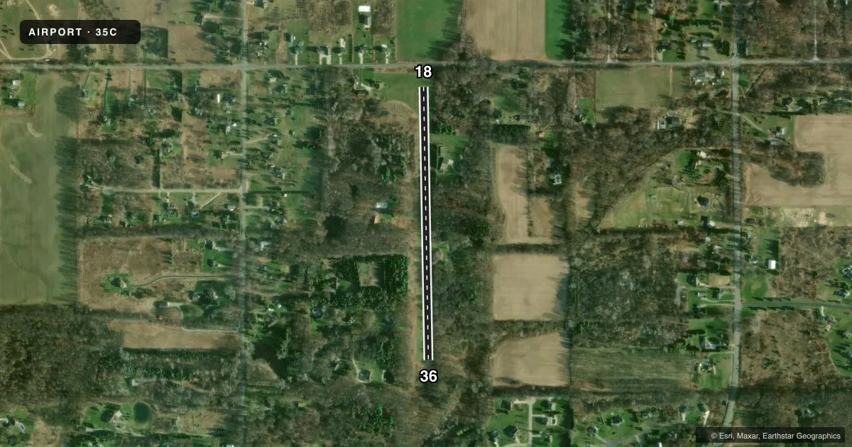
Airport sketch
Runways drawn to scale from FAA survey coordinates, rendered over satellite imagery. Not for navigation.
Approaches & charts
Services on the field
Fuel grades, oxygen, maintenance, ramp storage and lighting — as declared to the FAA by the airport operator.
Fuel & services
- Fuel
- Not available
- Oxygen (bottled)
- Not available
- Oxygen (bulk)
- Not available
- Airframe repair
- Not available
- Power plant repair
- Not available
Ramp & ground
- Transient storage
- Tie-down
- Landing fee
- No fee published
- Customs
- Not available
- Wind indicator
- Yes
- Segmented circle
- Yes
Fuel & FBOs
Cheapest 100LL and Jet A on the field and nearby. Always confirm with the FBO before taxi.
Airport notes
Surface conditions, obstructions, local procedures, lighting outages and other notes published with each FAA cycle.
General notes
- ARPT CLSD DEC-APR.
- BIRDS, DEER, & OTR WILDLIFE ON & INVOF ARPT.
- FOR CD CTC GREAT LAKES APCH AT 269-459-3344, WHEN APCH CLSD CTC CHICAGO ARTCC AT 630-906-8921.
Approach & departure obstructions
- 18RWY & DTHR MKD WITH 3 FT YELLOW CONES.
- 36RWY & DTHR MKD WITH 3 FT YELLOW CONES.
- 18CTLG OBSTN EXCEEDS A 45 DEG SLP.
- 36CTLG OBSTN EXCEEDS A 45 DEG SLP.
Other notes
- MANAGERRESIDES ON ARPT PREMISES.
- 18/36RWY SOFT WHEN WET.
VFR map & nearby airports
VFR sectional. Tap any ICAO chip to open that airport.
Key facts · 35C
Answer card- ICAO
- 35C
- Name
- WELLS
- Location
- ROCKFORD, MICHIGAN
- Elevation
- 890 ft MSL
- Traffic pattern altitude
- 1,890 ft MSL (1,000 AGL)
- Control tower
- Non-towered (use CTAF)
- Total runways
- 1
- Longest runway
- 18/36 · 2,200 ft
- Published ILS approaches
- 0
- Published frequencies
- 1
- Magnetic variation
- 4°
- Current flight rules
- LIFR
- Current wind
- 230° at 8 kt
- Favored runway now
- RWY 18
Wells Airport (35C) sits in Rockford, Michigan. Field elevation is 890 ft MSL. The airport has one runway. Runway 18/36 is 2,200 ft of turf, so plan for a short-field surface and check conditions before you go. The field is closed from December through April. That matters here. The runway is soft when wet. Runway 18 and runway 36 both have displaced thresholds marked with 3-foot yellow cones. Cataloged obstructions exceed a 45-degree slope at both runway ends. Wildlife is also reported on and near the airport.
There is no control tower. CTAF is 122.9. No ILS approaches are published. Pattern altitude is not published, so use the standard 1,000 ft AGL for light piston operations unless current local guidance says otherwise. The airport sits in a part of Michigan where seasonal use and surface condition matter more than anything else. If you are planning a first visit, verify the current Chart Supplement and call ahead for local field status before you launch. The manager lives on airport premises, which may help if you need current condition information. For clearance delivery, contact Great Lakes Approach. When approach is closed, contact Chicago ARTCC.