METAR & TAF 08C
08C does not publish a METAR.
Showing the nearest reporting station: KGRR (GERALD R FORD INTL) · 12.9 NM away. Conditions at 08C may differ.
METAR · KGRR
Observed 12:53Z
KGRR 271253Z 23008KT 1 1/2SM -RA BR BKN006 OVC060 24/24 A2985 RMK AO2 RAB30 SLP102 P0001 T02440239
- Wind
- 230° @ 8 kt
- Visibility
- 0.5 SM
- Temp / Dew
- 24°C / 24°C
- Altimeter
- 29.85 inHg
- Clouds
- OVC
- Density alt
- 1,915 ft
- Ceiling
- 600 ft AGL
- Rules
- LIFR
Airport info & contacts
Manager on record, flight service, ARTCC, attendance schedule and pattern altitude — published by the FAA and refreshed every 28 days.
Location
- From city
- 3 NM NW
- VFR sectional
- CHICAGO
- ARTCC
- ZAU · CHICAGO
- NOTAM facility
- LAN (NOTAM-D)
Airport manager
- Name
- NATHAN D BOYNTON
- Phone
- 616-457-5040
- Address
- 805 TAYLOR ST, JENISON MI 49428-9560
Flight service · Hours
- FSS LAN
- LANSING1-800-WX-BRIEF
- Attendance
- MON-FRI · 0800-1700
- SAT-SUN · IREG
Frequencies
Tap any row to copy the frequency to your clipboard.
Runways & pattern
Full pagePattern entry · RWY 32
LEFT TRAFFICRunway end performance
| End | TORA | TODA | ASDA | LDA | VGSI | Approach lights | Obstruction |
|---|---|---|---|---|---|---|---|
| 14 | — | — | — | — | — | — | 64', trees, 660' from thr, 100' R of cntrln, slope 7 |
| 32 | — | — | — | — | — | — | 80', trees, 450' from thr, 70' R of cntrln, slope 3 |
Declared distances in feet. TORA = takeoff run available, TODA = takeoff distance, ASDA = accelerate-stop, LDA = landing distance.
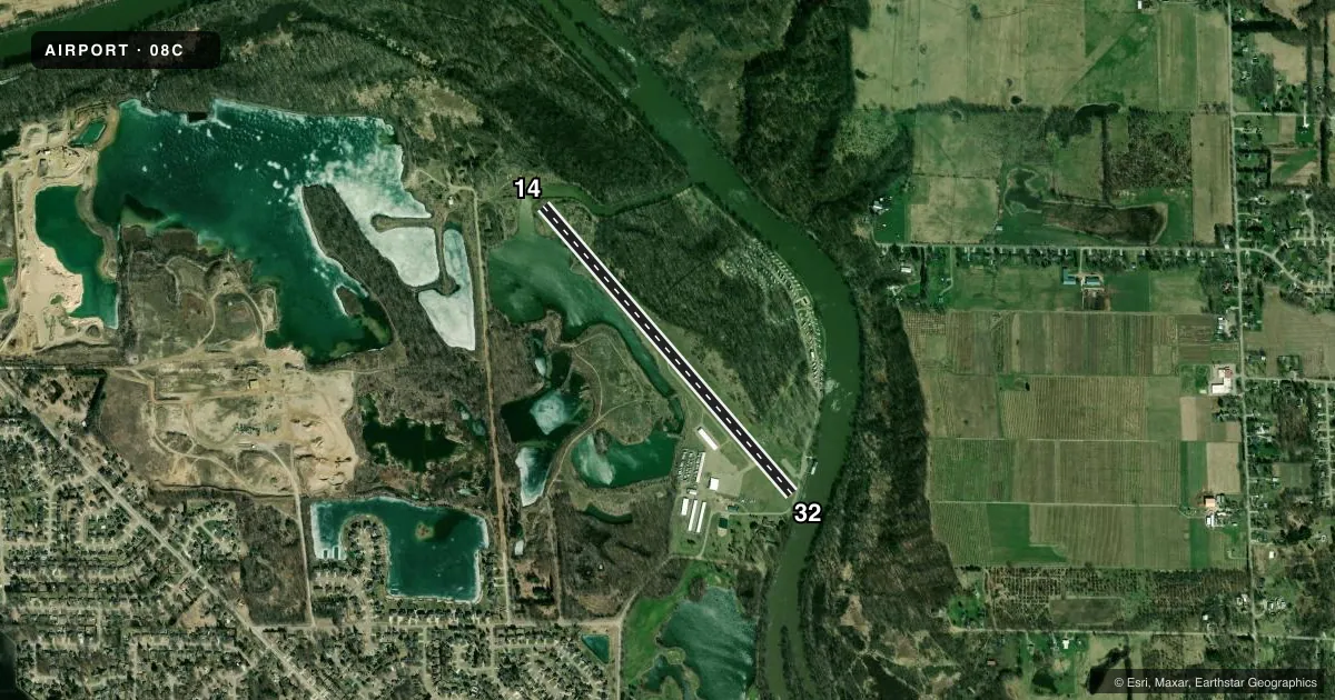
Airport sketch
Runways drawn to scale from FAA survey coordinates, rendered over satellite imagery. Not for navigation.
Approaches & charts
Services on the field
Fuel grades, oxygen, maintenance, ramp storage and lighting — as declared to the FAA by the airport operator.
Fuel & services
- Fuel
- 100LL
- Oxygen (bottled)
- Not available
- Oxygen (bulk)
- Not available
- Airframe repair
- Major
- Power plant repair
- Major
Ramp & ground
- Transient storage
- Tie-down
- Hangar
- Landing fee
- No fee published
- Lighting schedule
- SEE RMK
- Beacon schedule
- SEE RMK
- Beacon
- White / Green (civil land)(WG)
- Wind indicator
- Lighted
- Segmented circle
- Yes
Fuel & FBOs
Cheapest 100LL and Jet A on the field and nearby. Always confirm with the FBO before taxi.
Airport notes
Surface conditions, obstructions, local procedures, lighting outages and other notes published with each FAA cycle.
General notes
- DEER, BIRDS, & GROUNDHOGS ON & INVOF ARPT.
- ADMIN BLDG ACES: 5-3-2-1.
- FOR CD CTC GREAT LAKES APCH AT 269-459-3344, WHEN APCH CLSD CTC CHICAGO ARTCC AT 630-906-8921.
Lighting notes
- OPRS DUSK-2400.
- ACTVT MIRL RWY 14/32 - CTAF.
Fuel notes
- 100LLFUEL AVBL H24 SELF SVC.
Approach & departure obstructions
- 32+8 FT ROAD & 11-52 FT TREES, 55-155 FT DIST, 140 FT L/R.
- 14RWY NRS FADED.
- 32RWY NRS FADED.
- 32APCH SLP 20:1 TO DTHR OVR 80 FT TREES, 1900 FT DIST.
Other notes
- MANAGERCELL 616-291-2778.
VFR map & nearby airports
VFR sectional. Tap any ICAO chip to open that airport.
Key facts · 08C
Answer card- ICAO
- 08C
- Name
- RIVERVIEW
- Location
- JENISON, MICHIGAN
- Elevation
- 603 ft MSL
- Traffic pattern altitude
- 1,603 ft MSL (1,000 AGL)
- Control tower
- Non-towered (use CTAF)
- Total runways
- 1
- Longest runway
- 14/32 · 3,920 ft
- Published ILS approaches
- 0
- Published frequencies
- 1
- Magnetic variation
- –
- Current flight rules
- LIFR
- Current wind
- 230° at 8 kt
- Favored runway now
- RWY 32
Riverview Airport sits in Jenison, Michigan. Field elevation is 603 ft MSL. It has one runway. Runway 14/32 is 3,920 ft long with an asphalt surface. The airport is not towered. CTAF is 122.9.
No ILS approaches are published here. The pattern altitude is not published, so use the standard 1,000 ft AGL for light piston traffic unless the current FAA Chart Supplement says otherwise. The field is close enough to the Grand Rapids area that you should pay attention to local traffic flow and any current airport notes before you go. Runway numbers on both ends are reported as faded. There are also obstructions near runway 32, including trees close to the approach area.
Riverview Airport has one on-field FBO. Riverview Airport carries 100LL. Self-serve 100LL is available 24 hours a day. Medium intensity runway lights on 14/32 are activated by CTAF. The beacon operates from dusk to 2400. Deer, birds and groundhogs have been reported on and near the airport. If you need clearance delivery, contact Great Lakes Approach. If approach is closed, contact Chicago ARTCC. For any current noise, access, or operational changes, check the current FAA Chart Supplement or call the airport operator before departure.