METAR & TAF 39Z
39Z does not publish a METAR.
Showing the nearest reporting station: KMKG (MUSKEGON COUNTY) · 6.3 NM away. Conditions at 39Z may differ.
METAR · KMKG
Observed 05:55Z
KMKG 270555Z AUTO 19005KT 10SM CLR 23/21 A2983 RMK AO2 VIS 1 RWY 14 SLP098 60000 T02280206 10256 20217 58005 $
- Wind
- 190° @ 5 kt
- Visibility
- 10 SM
- Temp / Dew
- 23°C / 21°C
- Altimeter
- 29.83 inHg
- Clouds
- CLR
- Density alt
- 1,853 ft
- Ceiling
- Unlimited
- Rules
- VFR
Airport info & contacts
Manager on record, flight service, ARTCC, attendance schedule and pattern altitude — published by the FAA and refreshed every 28 days.
Location
- From city
- 2 NM SE
- VFR sectional
- CHICAGO
- Pattern altitude
- 800 ft AGL · 1,430 ft MSL
- ARTCC
- ZAU · CHICAGO
- NOTAM facility
- LAN (NOTAM-D)
Airport manager
- Name
- MICHAEL C ALMAN
- Phone
- 616-846-3977
- Address
- 18605 MIENK DR, FRUITPORT MI 49415-9405
Flight service · Hours
- FSS LAN
- LANSING1-800-WX-BRIEF
- Attendance
- IREG
Frequencies
Tap any row to copy the frequency to your clipboard.
Runways & pattern
Full pagePattern entry · RWY 27
RIGHT TRAFFICRunway end performance
| End | TORA | TODA | ASDA | LDA | VGSI | Approach lights | Obstruction |
|---|---|---|---|---|---|---|---|
| 09 | — | — | — | — | — | — | 60', trees, 0' from thr, 60' R of cntrln, slope 0 |
| 27 | — | — | — | — | — | — | 43', trees, 0' from thr, 63' R of cntrln, slope 0 |
Declared distances in feet. TORA = takeoff run available, TODA = takeoff distance, ASDA = accelerate-stop, LDA = landing distance.
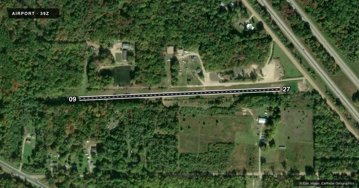
Airport sketch
Runways drawn to scale from FAA survey coordinates, rendered over satellite imagery. Not for navigation.
Approaches & charts
Services on the field
Fuel grades, oxygen, maintenance, ramp storage and lighting — as declared to the FAA by the airport operator.
Fuel & services
- Fuel
- Not available
- Oxygen (bottled)
- Not available
- Oxygen (bulk)
- Not available
- Airframe repair
- Major
- Power plant repair
- Major
Ramp & ground
- Transient storage
- Tie-down
- Landing fee
- No fee published
- Wind indicator
- Yes
- Segmented circle
- Yes
Fuel & FBOs
Cheapest 100LL and Jet A on the field and nearby. Always confirm with the FBO before taxi.
Airport notes
Surface conditions, obstructions, local procedures, lighting outages and other notes published with each FAA cycle.
General notes
- DEER & LRG BIRDS ON & INVOF ARPT.
- FOR CD CTC GREAT LAKES APCH AT 269-459-3344, WHEN APCH CLSD CTC CHICAGO ARTCC AT 630-906-8921.
- NO SNOW REMOVAL.
Approach & departure obstructions
- 09RWY & DTHR MKD WITH 3 FT YELLOW CONES.
- 273 FT YELLOW CONES.
- 09CTLG OBSTN EXCEEDS A 45 DEG SLP. APCH RATIO 0:1 TO DTHR OVR +68 FT TREES, 573 FT DIST, 60 FT R.
- 27CTLG OBSTN EXCEEDS A 45 DEG SLP.
Other notes
- SEE AIRSPACE CASE 97-AGL-654-NRA.
- 2ARPT IS CLSD NOV-MAR.
VFR map & nearby airports
VFR sectional. Tap any ICAO chip to open that airport.
Key facts · 39Z
Answer card- ICAO
- 39Z
- Name
- FLYING-A-RANCH
- Location
- FRUITPORT, MICHIGAN
- Elevation
- 630 ft MSL
- Traffic pattern altitude
- 1,430 ft MSL (800 AGL)
- Control tower
- Non-towered (use CTAF)
- Total runways
- 1
- Longest runway
- 09/27 · 1,925 ft
- Published ILS approaches
- 0
- Published frequencies
- 1
- Magnetic variation
- –
- Current flight rules
- VFR
- Current wind
- 190° at 5 kt
- Favored runway now
- RWY 27
Flying-A-Ranch Airport is in Fruitport, Michigan. The field elevation is 630 ft MSL. It has one runway. Runway 09/27 is 1,925 ft of turf, with magnetic headings 87° and 267°. The pattern altitude is 800 ft AGL, which is 1,430 ft MSL. There is no control tower. CTAF is 122.9.
No ILS approaches are published here. For clearance delivery, contact Great Lakes Approach at 269-459-3344. When approach is closed, contact Chicago ARTCC at 630-906-8921. The airport is closed from November through March. No snow removal is provided. Published remarks also call out deer and large birds in the area, so keep a sharp scan on arrival and departure. Runway 09 has a displaced threshold marked with three foot yellow cones. Runway 27 is also marked with three foot yellow cones. There is a cataloged obstruction near each end that matters on short turf operations. If you are planning a first visit, verify the current airspace case and any access details in the current FAA Chart Supplement before you go.