METAR & TAF 6D6
6D6 does not publish a METAR.
Showing the nearest reporting station: KGRR (GERALD R FORD INTL) · 19.6 NM away. Conditions at 6D6 may differ.
METAR · KGRR
Observed 15:53Z
KGRR 271553Z 22016KT 10SM FEW070 BKN120 OVC250 24/21 A2980 RMK AO2 RAE26 TSE36 SLP086 P0002 T02440206 $
- Wind
- 220° @ 16 kt
- Visibility
- 10 SM
- Temp / Dew
- 24°C / 21°C
- Altimeter
- 29.80 inHg
- Clouds
- OVC
- Density alt
- 2,289 ft
- Ceiling
- 12,000 ft AGL
- Rules
- VFR
Airport info & contacts
Manager on record, flight service, ARTCC, attendance schedule and pattern altitude — published by the FAA and refreshed every 28 days.
Location
- From city
- 3 NM S
- VFR sectional
- CHICAGO
- ARTCC
- ZAU · CHICAGO
- NOTAM facility
- LAN (NOTAM-D)
Airport manager
- Name
- PETER R JEPPESEN
- Phone
- 616-754-5534
- Address
- 10593 SW GREENVILLE RD, GREENVILLE MI 48838-8743
Flight service · Hours
- FSS LAN
- LANSING1-800-WX-BRIEF
- Attendance
- MON-FRI · 0800-1700
- SAT · 0800-1200
- SUN · ON CALL
Frequencies
Tap any row to copy the frequency to your clipboard.
Runways & pattern
Full pagePattern entry · RWY 18
LEFT TRAFFIC| Runway | Heading (°M) | Length | Surface | Traffic |
|---|---|---|---|---|
| 10/28 | 90° / 270° | 4,199 ft | ASPH | Standard L |
| 18/36Favored | 180° / 0° | 1,730 ft | TURF | Standard L |
Runway end performance
| End | TORA | TODA | ASDA | LDA | VGSI | Approach lights | Obstruction |
|---|---|---|---|---|---|---|---|
| 10 | — | — | — | — | PAPI 4-box left(3.5°) | — | 17', trees, 227' from thr, 258' R of cntrln, slope 1 |
| 28 | — | — | — | — | PAPI 4-box left(3°) | — | 38', trees, 656' from thr, 176' R of cntrln, slope 12 |
| 18 | — | — | — | — | — | — | 52', trees, 0' from thr, 125' R of cntrln, slope 0 |
| 36 | — | — | — | — | — | — | 40', trees, 364' from thr, 173' R of cntrln, slope 9 |
Declared distances in feet. TORA = takeoff run available, TODA = takeoff distance, ASDA = accelerate-stop, LDA = landing distance.
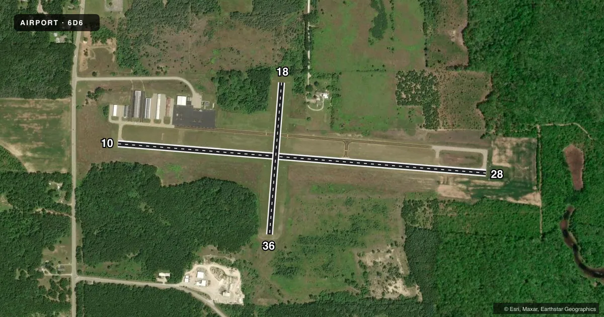
Airport sketch
Runways drawn to scale from FAA survey coordinates, rendered over satellite imagery. Not for navigation.
Approaches & charts
Services on the field
Fuel grades, oxygen, maintenance, ramp storage and lighting — as declared to the FAA by the airport operator.
Fuel & services
- Fuel
- 100LLA+
- Oxygen (bottled)
- Not available
- Oxygen (bulk)
- Not available
- Airframe repair
- Major
- Power plant repair
- Major
- Other services
- INSTR,RNTL
Ramp & ground
- Transient storage
- Tie-down
- Hangar
- Landing fee
- No fee published
- Customs
- Not available
- Lighting schedule
- SEE RMK
- Beacon schedule
- SS-SR
- Beacon
- White / Green (civil land)(WG)
- Wind indicator
- Lighted
- Segmented circle
- No
Fuel & FBOs
Cheapest 100LL and Jet A on the field and nearby. Always confirm with the FBO before taxi.
Airport notes
Surface conditions, obstructions, local procedures, lighting outages and other notes published with each FAA cycle.
General notes
- RWY 18/36 NO SNOW REMOVAL.
- DEER & BIRDS ON & INVOF ARPT.
- ADMIN BLDG ACES 5-3-2-1-*(STAR).
- FOR CD CTC GREAT LAKES APCH AT 269-459-3344, WHEN APCH CLSD CTC CHICAGO ARTCC AT 630-906-8921.
Lighting notes
- ACTVT REIL RWY 28; PAPI RWY 10 & 28; MIRL RWY 10/28 - CTAF.
Fuel notes
- 100LL100LL & JET A+ AVBL SELF SVC ONLY.
Approach & departure obstructions
- 183 FT YELLOW CONES.
- 36RWY & DTHR MKD WITH 3 FT YELLOW CONES.
- 18CTLG OBSTN EXCEEDS A 45 DEG SLP.
Other notes
- 5UNATNDD MAJOR HOLS. FOR SVC SUNDAYS CALL AMGR.
- MANAGERCELL 989-287-2629.
- 18/36RWY SFC ROUGH & UNEVEN; MAY BE SOFT IN SPRING.
VFR map & nearby airports
VFR sectional. Tap any ICAO chip to open that airport.
Key facts · 6D6
Answer card- ICAO
- 6D6
- Name
- GREENVILLE MUNI
- Location
- GREENVILLE, MICHIGAN
- Elevation
- 854.6 ft MSL
- Traffic pattern altitude
- 1,854.6 ft MSL (1,000 AGL)
- Control tower
- Non-towered (use CTAF)
- Total runways
- 2
- Longest runway
- 10/28 · 4,199 ft
- Published ILS approaches
- 0
- Published frequencies
- 4
- Magnetic variation
- 5°
- Current flight rules
- VFR
- Current wind
- 220° at 16 kt
- Favored runway now
- RWY 18
Greenville Muni is in Greenville, Michigan. The field elevation is 854.6 ft MSL. It has two runways. The longest is runway 10/28 at 4,199 ft. There is no control tower. Pattern altitude is not published, so use the standard 1,000 ft AGL for light piston operations unless the current FAA Chart Supplement says otherwise.
No ILS approaches are published here. Runway 10/28 is asphalt. Runway 18/36 is turf and only 1,730 ft long. The published remarks matter here. Runway 18/36 has no snow removal. The turf surface is rough and uneven. It may be soft in spring. There is also a cataloged obstruction near runway 18. Deer and birds are reported on and near the airport, so keep your scan active on arrival and departure.
Talon Aviation is the on-field FBO. It carries 100LL and Jet A. Fuel is self-serve only. Runway 28 has runway end identifier lights. Runways 10 and 28 have PAPI and medium intensity runway lights. For clearance delivery, contact Great Lakes Approach. If approach is closed, use Chicago ARTCC. First-time pilots should plan for a non-towered field with mixed pavement and turf. Verify current procedures with the airport operator before you go.