METAR & TAF 24C
24C does not publish a METAR.
Showing the nearest reporting station: KGRR (GERALD R FORD INTL) · 9.0 NM away. Conditions at 24C may differ.
METAR · KGRR
Observed 15:37Z
KGRR 271537Z COR 21014KT 9SM FEW060 SCT100 BKN130 OVC250 23/20 A2981 RMK AO2 RAE26 TSE36 P0002 T02330200 $
- Wind
- 210° @ 14 kt
- Visibility
- 9 SM
- Temp / Dew
- 23°C / 20°C
- Altimeter
- 29.81 inHg
- Clouds
- OVC
- Density alt
- 1,941 ft
- Ceiling
- 13,000 ft AGL
- Rules
- VFR
Airport info & contacts
Manager on record, flight service, ARTCC, attendance schedule and pattern altitude — published by the FAA and refreshed every 28 days.
Location
- From city
- 1 NM N
- VFR sectional
- CHICAGO
- ARTCC
- ZAU · CHICAGO
- NOTAM facility
- LAN (NOTAM-D)
Airport manager
- Name
- CASEY K BROWN
- Phone
- 616-987-0821
- Address
- 770 LINCOLN LAKE AVE SE, LOWELL MI 49331-9421
Flight service · Hours
- FSS LAN
- LANSING1-800-WX-BRIEF
- Attendance
- 0900-1700
Frequencies
Tap any row to copy the frequency to your clipboard.
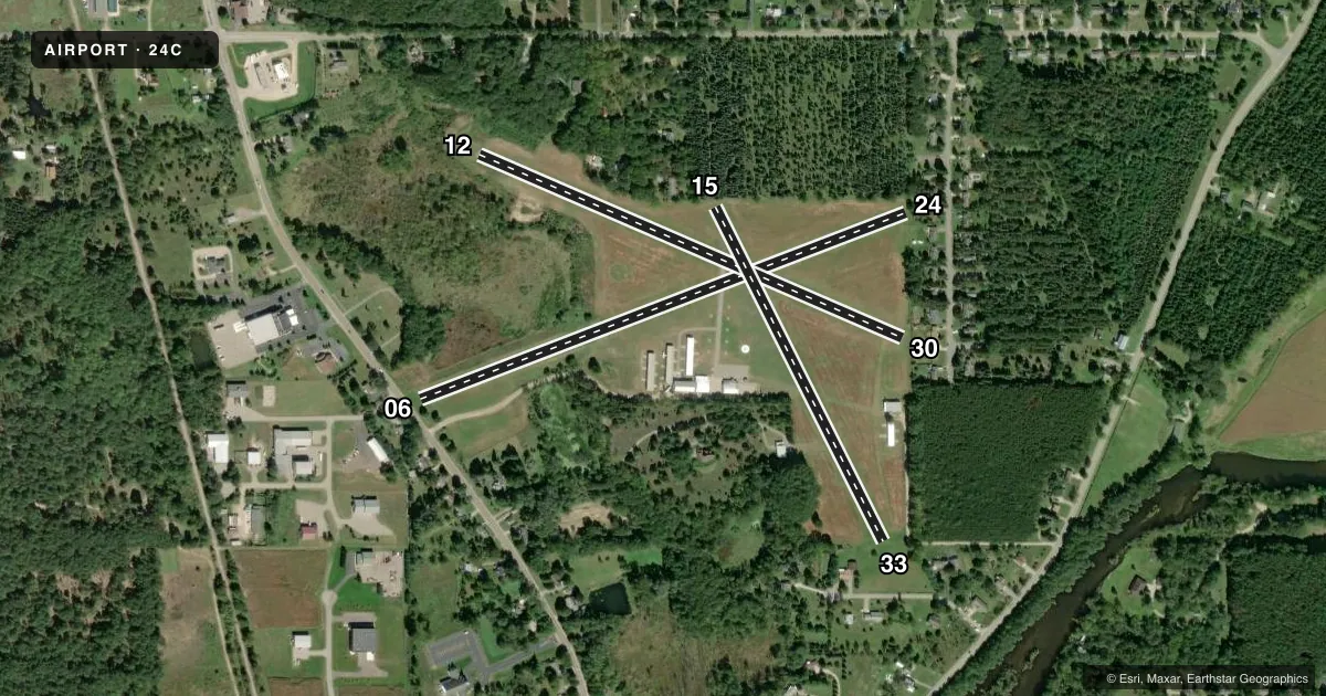
Runways & pattern
Full pagePattern entry · RWY 24
LEFT TRAFFIC| Runway | Heading (°M) | Length | Surface | Traffic |
|---|---|---|---|---|
| 06/24Favored | 65° / 245° | 2,700 ft | TURF | Standard L |
| 12/30 | 109° / 289° | 2,394 ft | ASPH | Standard L |
| 15/33 | 149° / 329° | 1,940 ft | TURF | Standard L |
Runway end performance
| End | TORA | TODA | ASDA | LDA | VGSI | Approach lights | Obstruction |
|---|---|---|---|---|---|---|---|
| 06 | — | — | — | — | — | — | 42', trees, 0' from thr, 86' R of cntrln, slope 0 |
| 24 | — | — | — | — | — | — | 49', trees, 0' from thr, 100' R of cntrln, slope 0 |
| 12 | — | — | — | — | — | — | 14', tree, 200' from thr, 69' R of cntrln, slope 0 |
| 30 | — | — | — | — | — | — | 12', bldg, 200' from thr, 0' R of cntrln, slope 0 |
| 15 | — | — | — | — | — | — | 48', tree, 0' from thr, 112' R of cntrln, slope 0 |
| 33 | — | — | — | — | — | — | 24', tree, 20' from thr, 118' R of cntrln, slope 0 |
Declared distances in feet. TORA = takeoff run available, TODA = takeoff distance, ASDA = accelerate-stop, LDA = landing distance.
Airport sketch
Runways drawn to scale from FAA survey coordinates, rendered over satellite imagery. Not for navigation.
Approaches & charts
Services on the field
Fuel grades, oxygen, maintenance, ramp storage and lighting — as declared to the FAA by the airport operator.
Fuel & services
- Fuel
- 100LL
- Oxygen (bottled)
- Not available
- Oxygen (bulk)
- Not available
- Airframe repair
- Not available
- Power plant repair
- Not available
- Other services
- INSTR
Ramp & ground
- Transient storage
- Tie-down
- Landing fee
- No fee published
- Customs
- Not available
- Lighting schedule
- SEE RMK
- Wind indicator
- Lighted
- Segmented circle
- Yes
Fuel & FBOs
Cheapest 100LL and Jet A on the field and nearby. Always confirm with the FBO before taxi.
Airport notes
Surface conditions, obstructions, local procedures, lighting outages and other notes published with each FAA cycle.
General notes
- FOR CD CTC GREAT LAKES APCH AT 269-459-3344, WHEN APCH CLSD CTC CHICAGO ARTCC AT 630-906-8921.
- DEER & LRG BIRDS ON & INVOF ARPT.
Lighting notes
- ACTVT LIRL RWY 12/30 - CTAF.
Fuel notes
- 100LLAVBL H24 SELF SVC - CTC AMGR FOR DTLS.
Runway surface & condition
- 06/24NO SNOW REMOVAL.
- 15/33NO SNOW REMOVAL.
Approach & departure obstructions
- 3050 FT TREES, 90 FT DIST, 90 FT R; 6 FT FENCE, 0 FT DIST, 125 FT R.
- 06RWY & DTHR MKD WITH 3 FT YELLOW CONES.
- 15RWY & DTHR MKD WITH 3 FT YELLOW CONES.
- 24RWY & DTHR MKD WITH 3 FT YELLOW CONES.
- 33RWY & DTHR MKD WITH 3 FT YELLOW CONES.
- 06APCH RATIO 22:1 TO DTHR BASED ON STRAIGHT OUT OVR 54 FT TREE, 1225 FT DIST.
- 12CTLG OBSTN EXCEEDS A 45 DEG SLP.
- 15APCH RATIO 12:1 TO DTHR OVR 53 FT TREE, 660 FT DIST, 50 FT L.
- 24APCH RATIO 22:1 TO DTHR BASED ON STRAIGHT OUT OVR 63 FT TREES, 1404 FT DIST.
- 30APCH RATIO 17:1 TO DTHR BASED ON STRAIGHT OUT OVR 45 FT TREE, 795 FT DIST.
- 33APCH RATIO 20:1 TO DTHR BASED ON STRAIGHT OUT OVR 45 FT TREES, 940 FT DIST.
Other notes
- RPRS ONLY AVBL ON CALL.
- ESTABD BFR 1959.
VFR map & nearby airports
VFR sectional. Tap any ICAO chip to open that airport.
Key facts · 24C
Answer card- ICAO
- 24C
- Name
- LOWELL CITY
- Location
- LOWELL, MICHIGAN
- Elevation
- 681 ft MSL
- Traffic pattern altitude
- 1,681 ft MSL (1,000 AGL)
- Control tower
- Non-towered (use CTAF)
- Total runways
- 3
- Longest runway
- 06/24 · 2,700 ft
- Published ILS approaches
- 0
- Published frequencies
- 2
- Magnetic variation
- 4°
- Current flight rules
- VFR
- Current wind
- 210° at 14 kt
- Favored runway now
- RWY 24
Lowell City Airport (24C) sits in Lowell, Michigan at 681 ft MSL. It has three runways. The longest is 2,700 ft. This is a non-towered field, so use CTAF 123.0 for traffic calls and UNICOM 123.0 for airport coordination. No ILS approaches are published here. The pattern altitude is not published, so plan on the standard 1,000 ft AGL for light piston operations unless the current FAA Chart Supplement says otherwise.
The field has one on-field FBO, Lowell City Airport. Fuel grades are not reported in the facts block, but 100LL is available 24 hours self service. Call the airport manager at (616) 987-0821 for details before you go. The runway mix is turf and asphalt. Runway 12/30 is asphalt. Runways 06/24 and 15/33 are turf. Published remarks note no snow removal on runway 06/24. Deer and large birds are also reported on and near the airport, so keep your scan active on arrival and departure.
There are several published obstacle notes. Runway 06 has tree clearance issues on the approach. Runway 12 has an obstruction that exceeds a 45 degree slope. Runway 30 also has close-in trees and a fence near the approach path. If you are new to the field, brief the displaced thresholds and use extra caution on the turf runways. The runway and displaced threshold on 06/24 are marked with 3 foot yellow cones. Low intensity lights on runway 12/30 are activated by using the CTAF.