METAR & TAF 38C
38C does not publish a METAR.
Showing the nearest reporting station: KRQB (ROBEN-HOOD) · 7.5 NM away. Conditions at 38C may differ.
METAR · KRQB
Observed 18:15Z
KRQB 271815Z AUTO 27006KT 9SM -RA FEW055 OVC110 22/20 A2985 RMK AO2 PRESRR
- Wind
- 270° @ 6 kt
- Visibility
- 9 SM
- Temp / Dew
- 22°C / 20°C
- Altimeter
- 29.85 inHg
- Clouds
- OVC
- Density alt
- 2,039 ft
- Ceiling
- 11,000 ft AGL
- Rules
- VFR
Airport info & contacts
Manager on record, flight service, ARTCC, attendance schedule and pattern altitude — published by the FAA and refreshed every 28 days.
Location
- From city
- 2 NM NW
- VFR sectional
- CHICAGO
- ARTCC
- ZAU · CHICAGO
- NOTAM facility
- LAN (NOTAM-D)
Airport manager
- Name
- JAMES CAIN
- Phone
- 231-580-1073
- Address
- 8731 OLD STATE RD, STANWOOD MI 49346-9083
Flight service · Hours
- FSS LAN
- LANSING1-800-WX-BRIEF
- Attendance
- IREG
Frequencies
Tap any row to copy the frequency to your clipboard.
Runways & pattern
Full pagePattern entry · RWY 18
LEFT TRAFFICRunway end performance
| End | TORA | TODA | ASDA | LDA | VGSI | Approach lights | Obstruction |
|---|---|---|---|---|---|---|---|
| 18 | — | — | — | — | — | — | 78', trees, 0' from thr, 92' R of cntrln, slope 0 |
| 36 | — | — | — | — | — | — | 10', road, 0' from thr, 110' R of cntrln, slope 0 |
Declared distances in feet. TORA = takeoff run available, TODA = takeoff distance, ASDA = accelerate-stop, LDA = landing distance.
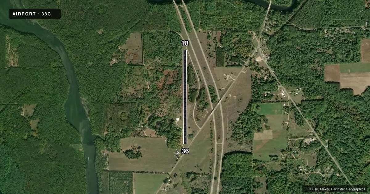
Airport sketch
Runways drawn to scale from FAA survey coordinates, rendered over satellite imagery. Not for navigation.
Approaches & charts
Services on the field
Fuel grades, oxygen, maintenance, ramp storage and lighting — as declared to the FAA by the airport operator.
Fuel & services
- Fuel
- Not available
- Oxygen (bottled)
- Not available
- Oxygen (bulk)
- Not available
- Airframe repair
- Not available
- Power plant repair
- Not available
Ramp & ground
- Transient storage
- Tie-down
- Landing fee
- No fee published
- Customs
- Not available
- Wind indicator
- Lighted
- Segmented circle
- Yes
Fuel & FBOs
Cheapest 100LL and Jet A on the field and nearby. Always confirm with the FBO before taxi.
Airport notes
Surface conditions, obstructions, local procedures, lighting outages and other notes published with each FAA cycle.
General notes
- DEER, LRG BIRDS, & OTR WILDLIFE ON & INVOF ARPT.
- RWY 36: +25 FT PLINE, 650 FT TO DTHR, 125 FT L/R.
- FOR CD CTC GREAT LAKES APCH AT 269-459-3344, WHEN APCH CLSD CTC CHICAGO ARTCC AT 630-906-8921.
- NO SNOW REMOVAL.
Approach & departure obstructions
- 18RWY & DTHR MKD WITH 3 FT YELLOW CONES.
- 36RWY & DTHR MKD WITH 3 FT YELLOW CONES.
- 18CTLG OBSTN EXCEEDS A 45 DEG SLP. APCH RATIO 1:1 TO DTHR OVR +30 FT TREES, 0 FT DIST, 105 FT R.
- 36CTLG OBSTN EXCEEDS A 45 DEG SLP. APCH RATIO 3:1 TO DTHR OVR +33 FT TREES, 130 FT DIST, 140 FT R.
Other notes
- PRVDD ARPT ABNDD WHEN NEW HWY IS BUILT.
VFR map & nearby airports
VFR sectional. Tap any ICAO chip to open that airport.
Key facts · 38C
Answer card- ICAO
- 38C
- Name
- CAIN FLD
- Location
- STANWOOD, MICHIGAN
- Elevation
- 897 ft MSL
- Traffic pattern altitude
- 1,897 ft MSL (1,000 AGL)
- Control tower
- Non-towered (use CTAF)
- Total runways
- 1
- Longest runway
- 18/36 · 3,472 ft
- Published ILS approaches
- 0
- Published frequencies
- 1
- Magnetic variation
- 4°
- Current flight rules
- VFR
- Current wind
- 270° at 6 kt
- Favored runway now
- RWY 18
CAIN FLD sits near Stanwood, Michigan. Field elevation is 897 ft MSL. It has one runway. Runway 18/36 is a 3,472 ft turf strip. There is no control tower. CTAF is 122.9. No ILS approaches are published here.
Pattern altitude is not published. Use the standard 1,000 ft AGL for light piston traffic unless the current Chart Supplement says otherwise. That puts the pattern at 1,897 ft MSL based on the field elevation. The airport has no on-field FBOs listed, so plan ahead for fuel and services before you go. Check with the airport operator or the FBO directly by phone if you need current availability.
The published remarks matter here. There are cataloged obstructions near both runway ends. Runway 18 has trees close in on the approach side. Runway 36 has trees near the displaced threshold plus a power line farther out. The runway and displaced threshold are marked with yellow cones. There is no snow removal. Wildlife is also reported on and near the airport. This is a turf field with a single 3,472 ft runway, so soft-field technique and a conservative performance check make sense. If you need clearance delivery, contact Great Lakes Approach. When approach is closed, contact Chicago ARTCC.