METAR & TAF KRQB
Current METAR
Observed 19:15Z
KRQB 271915Z AUTO 20017G21KT 6SM -RA BR FEW065 SCT080 OVC100 22/21 A2969 RMK AO2 PRESFR
- Wind
- 200° @ 17G21 kt
- Visibility
- 6 SM
- Temp / Dew
- 22°C / 21°C
- Altimeter
- 29.69 inHg
- Clouds
- OVC
- Density alt
- 2,358 ft
- Ceiling
- 10,000 ft AGL
- Rules
- VFR
Airport info & contacts
Manager on record, flight service, ARTCC, attendance schedule and pattern altitude — published by the FAA and refreshed every 28 days.
Location
- From city
- 2 NM NW
- VFR sectional
- CHICAGO
- ARTCC
- ZMP · MINNEAPOLIS
- NOTAM facility
- RQB (NOTAM-D)
Airport manager
- Name
- STEVE SCHROEDER, FIRE CHIEF
- Phone
- 231-796-5600
- Address
- 21325 18 MILE RD, BIG RAPIDS MI 49307-9721
Flight service · Hours
- FSS LAN
- LANSING1-800-WX-BRIEF
- Attendance
- MON-FRI · 0800-1700
- SAT · 0800-1500
Frequencies
Tap any row to copy the frequency to your clipboard.
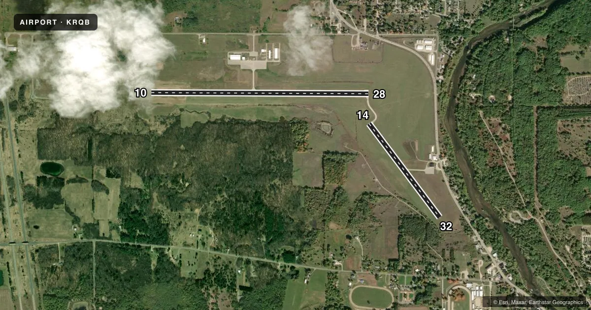
Runways & pattern
Full pagePattern entry · RWY 14
LEFT TRAFFIC| Runway | Heading (°M) | Length | Surface | Traffic |
|---|---|---|---|---|
| 10/28 | 84° / 264° | 5,003 ft | ASPH | Standard L |
| 14/32Favored | 137° / 317° | 2,699 ft | ASPH | Standard L |
Runway end performance
| End | TORA | TODA | ASDA | LDA | VGSI | Approach lights | Obstruction |
|---|---|---|---|---|---|---|---|
| 10 | — | — | — | — | PAPI 2-box left(3.75°) | — | — |
| 28 | — | — | — | — | PAPI 4-box left(3.08°) | — | — |
Declared distances in feet. TORA = takeoff run available, TODA = takeoff distance, ASDA = accelerate-stop, LDA = landing distance.
Airport sketch
Runways drawn to scale from FAA survey coordinates, rendered over satellite imagery. Not for navigation.
Approaches & charts
Services on the field
Fuel grades, oxygen, maintenance, ramp storage and lighting — as declared to the FAA by the airport operator.
Fuel & services
- Fuel
- 100LLA+
- Airframe repair
- Major
- Power plant repair
- Major
- Other services
- AMB,INSTR,RNTL
Ramp & ground
- Transient storage
- Tie-down
- Hangar
- Landing fee
- No fee published
- Customs
- Not available
- Lighting schedule
- SEE RMK
- Beacon schedule
- SS-SR
- Beacon
- White / Green (civil land)(WG)
- Wind indicator
- Lighted
- Segmented circle
- No
Fuel & FBOs
Cheapest 100LL and Jet A on the field and nearby. Always confirm with the FBO before taxi.
Airport notes
Surface conditions, obstructions, local procedures, lighting outages and other notes published with each FAA cycle.
General notes
- BIRDS & DEER ON & INVOF ARPT.
- ADMIN BLDG ACES: PRESS 5, THEN 3 & 2 SIMUL, THEN 1.
- FOR CD CTC MINNEAPOLIS ARTCC AT 651-463-5588.
Lighting notes
- ACTVT REIL RWY 10 & 28; PAPI RWY 10 & 28; MIRL RWY 10/28 & 14/32 - CTAF.
Fuel notes
- 100LLAVBL H24 SELF SVC.
- A+SINGLE POINT & OVERWING AVBL.
Other notes
- LDG FEE FOR COML ACFT WAIVED WITH MNM FUEL PURCHASE.
- MANAGERCITY HALL 231-679-1583.
VFR map & nearby airports
VFR sectional. Tap any ICAO chip to open that airport.
Key facts · KRQB
Answer card- ICAO
- KRQB
- Name
- ROBEN-HOOD
- Location
- BIG RAPIDS, MICHIGAN
- Elevation
- 994.2 ft MSL
- Traffic pattern altitude
- 1,994.2 ft MSL (1,000 AGL)
- Control tower
- Non-towered (use CTAF)
- Total runways
- 2
- Longest runway
- 10/28 · 5,003 ft
- Published ILS approaches
- 0
- Published frequencies
- 2
- Magnetic variation
- 6°
- Current flight rules
- VFR
- Current wind
- 200° at 17 kt
- Favored runway now
- RWY 14
Roben-Hood Airport sits in Big Rapids, Michigan. Field elevation is 994.2 ft MSL. The airport has two asphalt runways. The longest is runway 10/28 at 5,003 ft. Runway 14/32 is 2,699 ft.
This is an untowered field. CTAF and UNICOM are both 122.8. No ILS approaches are published. Pattern altitude is not published. Use the standard 1,000 ft AGL for light piston traffic unless the current Chart Supplement says otherwise. The field sits in a mixed local traffic environment, so keep your scan tight on departure and arrival.
Roben-Hood Airport is the on-field FBO. It carries 100LL and Jet A. Published remarks say 100LL is available 24 hours a day self-serve. They also note A plus fuel with single point and overwing fueling. Runway 10 and runway 28 have REILs. Medium intensity runway lights are on both runways and are controlled by CTAF. The PAPI on runway 10 is unusable beyond 5 degrees right of centerline.
Birds and deer are reported on and near the airport. That is the main operational item to plan around here. If you need clearance delivery, contact Minneapolis ARTCC. Check the current FAA Chart Supplement before you go for any updates to remarks or local procedures.