METAR & TAF 61D
61D does not publish a METAR.
Showing the nearest reporting station: KAZO (KALAMAZOO/BATTLE CREEK INTL) · 14.7 NM away. Conditions at 61D may differ.
METAR · KAZO
Observed 01:53Z
KAZO 270153Z 00000KT 10SM CLR 24/20 A2988 RMK AO2 SLP113 T02440200
- Wind
- 000° @ 0 kt
- Visibility
- 10 SM
- Temp / Dew
- 24°C / 20°C
- Altimeter
- 29.88 inHg
- Clouds
- CLR
- Density alt
- 2,025 ft
- Ceiling
- Unlimited
- Rules
- VFR
Airport info & contacts
Manager on record, flight service, ARTCC, attendance schedule and pattern altitude — published by the FAA and refreshed every 28 days.
Location
- From city
- 2 NM N
- VFR sectional
- CHICAGO
- ARTCC
- ZAU · CHICAGO
- NOTAM facility
- LAN (NOTAM-D)
Airport manager
- Name
- VIRGIL WILLIAMS
- Phone
- 269-492-5022
- Address
- 132 COUNTRY CLUB BLVD, PLAINWELL MI 49080-9120
Flight service · Hours
- FSS LAN
- LANSING1-800-WX-BRIEF
- Attendance
- IREG
Frequencies
Tap any row to copy the frequency to your clipboard.
Runways & pattern
Full pagePattern entry · RWY 09
LEFT TRAFFIC| Runway | Heading (°M) | Length | Surface | Traffic |
|---|---|---|---|---|
| 09/27 | 89° / 269° | 2,650 ft | ASPH | Standard L |
| 01/19 | 7° / 187° | 2,550 ft | TURF | Standard L |
Runway end performance
| End | TORA | TODA | ASDA | LDA | VGSI | Approach lights | Obstruction |
|---|---|---|---|---|---|---|---|
| 09 | — | — | — | — | — | — | 17', road, 200' from thr, 125' R of cntrln, slope 1 |
| 27 | — | — | — | — | — | — | 55', trees, 201' from thr, 0' R of cntrln, slope 1 |
| 01 | — | — | — | — | — | — | 15', road, 20' from thr, 50' R of cntrln, slope 1 |
| 19 | — | — | — | — | — | — | 74', trees, 120' from thr, 50' R of cntrln, slope 1 |
Declared distances in feet. TORA = takeoff run available, TODA = takeoff distance, ASDA = accelerate-stop, LDA = landing distance.
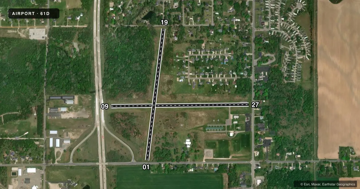
Airport sketch
Runways drawn to scale from FAA survey coordinates, rendered over satellite imagery. Not for navigation.
Approaches & charts
Services on the field
Fuel grades, oxygen, maintenance, ramp storage and lighting — as declared to the FAA by the airport operator.
Fuel & services
- Fuel
- 100LL
- Oxygen (bottled)
- Not available
- Oxygen (bulk)
- Not available
- Airframe repair
- Major
- Power plant repair
- Major
- Other services
- INSTR
Ramp & ground
- Transient storage
- Tie-down
- Landing fee
- No fee published
- Customs
- Not available
- Lighting schedule
- SEE RMK
- Wind indicator
- Lighted
- Segmented circle
- No
Fuel & FBOs
Cheapest 100LL and Jet A on the field and nearby. Always confirm with the FBO before taxi.
Airport notes
Surface conditions, obstructions, local procedures, lighting outages and other notes published with each FAA cycle.
General notes
- FOR FLD CONDS CALL AMGR.
- FOR CD CTC GREAT LAKES APCH AT 269-459-3344, WHEN APCH CLSD CTC CHICAGO ARTCC AT 630-906-8921.
- RWY 19 DTHR 1350 FT, EXTDS BYD RWY MIDPT.
Lighting notes
- ACTVT LIRL RWY 09/27 - 5 CLICKS CTAF.
Fuel notes
- 100LLSELF SVC.
Approach & departure obstructions
- 094 FT FENCE, 50 FT DIST; 17 FT ROAD, 140 FT DIST.
- 276 FT FENCE, 62 FT DIST; 15 FT ROAD, 100 FT DIST; 55 FT TREE, 155 FT DIST.
- 01RWY & DTHR MKD WITH YELLOW CONES.
- 19RWY & DTHR MKD WITH YELLOW CONES.
- 01APCH SLP 19:1 TO DTHR OVR 60 FT TREE, 1150 FT DIST, 10 FT L.
- 09APCH SLP 6:1 TO DTHR OVR 35 FT TREE, 240 FT DIST, 130 FT R.
- 19APCH SLP 14:1 TO DTHR OVR 60 FT TREE, 854 FT DIST, 110 FT R.
- 27APCH SLP 7:1 TO DTHR OVR 13 FT TREE, 100 FT DIST, 130 FT R.
Other notes
- 1CK FOR CONDS.
- 09/27EXTSV CRACKING & RAVELING.
VFR map & nearby airports
VFR sectional. Tap any ICAO chip to open that airport.
Key facts · 61D
Answer card- ICAO
- 61D
- Name
- VIRGIL L WILLIAMS PLAINWELL MUNI
- Location
- PLAINWELL, MICHIGAN
- Elevation
- 722 ft MSL
- Traffic pattern altitude
- 1,722 ft MSL (1,000 AGL)
- Control tower
- Non-towered (use CTAF)
- Total runways
- 2
- Longest runway
- 09/27 · 2,650 ft
- Published ILS approaches
- 0
- Published frequencies
- 2
- Magnetic variation
- –
- Current flight rules
- VFR
- Current wind
- 000° at 0 kt
- Favored runway now
- –
Virgil L Williams Plainwell Muni sits in Plainwell, Michigan. The field elevation is 722 ft MSL. It has two runways. The longest is 2,650 ft on runway 09/27. Runway 01/19 is turf at 2,550 ft. There is no control tower. CTAF and UNICOM are both 122.8.
No ILS approaches are published here. Pattern altitude is not published, so use the standard 1,000 ft AGL for light piston traffic unless the current FAA Chart Supplement says otherwise. The on-field FBO is Plainwell Municipal Airport. It carries AVGAS 100LL. Self-serve 100LL is published. Call the airport manager for field conditions before you go. For clearance delivery, contact Great Lakes Approach at 269-459-3344. When approach is closed, contact Chicago ARTCC at 630-906-8921.
A first-time pilot should pay close attention to runway condition and obstacles. Runway 09/27 has extensive cracking and raveling. Runway 19 has a displaced threshold that starts 1,350 ft down the strip. Yellow cones mark the runway and displaced threshold. There are obstacle notes near both ends of the turf runway. The airport is non-towered, so expect self-announce traffic and verify current conditions before arrival.