METAR & TAF M86
M86 does not publish a METAR.
Showing the nearest reporting station: KLWA (SOUTH HAVEN AREA RGNL) · 9.2 NM away. Conditions at M86 may differ.
METAR · KLWA
Observed 04:35Z
KLWA 270435Z AUTO 19004KT 10SM CLR 23/21 A2985 RMK AO2
- Wind
- 190° @ 4 kt
- Visibility
- 10 SM
- Temp / Dew
- 23°C / 21°C
- Altimeter
- 29.85 inHg
- Clouds
- CLR
- Density alt
- 1,834 ft
- Ceiling
- Unlimited
- Rules
- VFR
Airport info & contacts
Manager on record, flight service, ARTCC, attendance schedule and pattern altitude — published by the FAA and refreshed every 28 days.
Location
- From city
- 2 NM SW
- VFR sectional
- CHICAGO
- ARTCC
- ZAU · CHICAGO
- NOTAM facility
- LAN (NOTAM-D)
Airport manager
- Name
- ED WALLE
- Phone
- 269-214-6898
- Address
- 6025 107 AV, PULLMAN MI 49450
Flight service · Hours
- FSS LAN
- LANSING1-800-WX-BRIEF
- Attendance
- Unattended
Frequencies
Tap any row to copy the frequency to your clipboard.
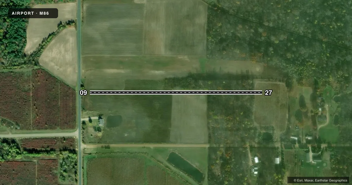
Runways & pattern
Full pagePattern entry · RWY 27
LEFT TRAFFICRunway end performance
| End | TORA | TODA | ASDA | LDA | VGSI | Approach lights | Obstruction |
|---|---|---|---|---|---|---|---|
| 09 | — | — | — | — | — | — | 15', road, 15' from thr, 0' R of cntrln, slope 1 |
| 27 | — | — | — | — | — | — | 37', trees, 258' from thr, 0' R of cntrln, slope 6 |
Declared distances in feet. TORA = takeoff run available, TODA = takeoff distance, ASDA = accelerate-stop, LDA = landing distance.
Airport sketch
Runways drawn to scale from FAA survey coordinates, rendered over satellite imagery. Not for navigation.
Approaches & charts
Services on the field
Fuel grades, oxygen, maintenance, ramp storage and lighting — as declared to the FAA by the airport operator.
Fuel & services
- Fuel
- Not available
Ramp & ground
- Transient storage
- Not published
- Wind indicator
- No
- Segmented circle
- No
Fuel & FBOs
Cheapest 100LL and Jet A on the field and nearby. Always confirm with the FBO before taxi.
Airport notes
Surface conditions, obstructions, local procedures, lighting outages and other notes published with each FAA cycle.
General notes
- DEER & ANIMALS ON & INVOF ARPT.
- 60 FT TREES, 130 FT BOTH SIDES OF RY CENTERLINE.
- FOR CD CTC GREAT LAKES APCH AT 269-459-3344, WHEN APCH CLSD CTC CHICAGO ARTCC AT 630-906-8921.
Approach & departure obstructions
- 09RY 09/27 DSPLCD THLDS MKD WITH THREE, 3 FT YELLOW CONES EACH SIDE OF RY; RY DEFINED BY MOWING.
- 09APCH RATIO 20:1 AT DSPLCD THLD, 47 FT TREES, 958 FT DSTC, 0B.
- 27APCH RATIO 0:1 AT DSPLCD THLD +60 FT TREES 0 FT DSTC, 130 FT L. APCH RATION 14:1 BASED ON 52 FT TREES, 768 FT. DSTC. ALSO, 50 FT TREES, 0 FT DSTC, 130 FT L/R EAST HALF OF RY.
- 09ALSO +25 FT PLINE; 228 FT FM RY END L/R. MKD WITH ONE ORANGE BALL.
Other notes
- 09/27ROUGH SFC WITH SOFT AREAS, STANDING WATER, & DIRT PILES. RY SOFT IN SPRING & WHEN WET.
VFR map & nearby airports
VFR sectional. Tap any ICAO chip to open that airport.
Key facts · M86
Answer card- ICAO
- M86
- Name
- WALLE FLD
- Location
- PULLMAN, MICHIGAN
- Elevation
- 635 ft MSL
- Traffic pattern altitude
- 1,635 ft MSL (1,000 AGL)
- Control tower
- Non-towered (use CTAF)
- Total runways
- 1
- Longest runway
- 09/27 · 1,699 ft
- Published ILS approaches
- 0
- Published frequencies
- 1
- Magnetic variation
- 3°
- Current flight rules
- VFR
- Current wind
- 190° at 4 kt
- Favored runway now
- RWY 27
WALLE FLD is in Pullman, Michigan. Field elevation is 635 ft MSL. The airport has one runway, 09/27. The longest strip is 1,699 ft of turf. There is no control tower. CTAF is 122.9. No ILS approaches are published.
Pattern altitude is not published, so use the standard 1,000 ft AGL for light piston traffic unless the current FAA Chart Supplement says otherwise. That puts the traffic pattern at 1,635 ft MSL based on the field elevation. The runway is marked by mowing. The published remarks also call out displaced thresholds on both ends. The surface is rough with soft spots, standing water and dirt piles. It is soft in spring and when wet. Deer and other animals are reported on and near the airport. There are also trees close to the runway environment. A power line is near the 09 end. This is a short turf field with real obstacle and surface limits, so plan conservatively and check conditions before you go. No on-field FBOs are listed, so contact the airport operator directly before arrival if you need current services.