METAR & TAF 40C
40C does not publish a METAR.
Showing the nearest reporting station: KBEH (SOUTHWEST MICHIGAN RGNL) · 8.9 NM away. Conditions at 40C may differ.
METAR · KBEH
Observed 04:53Z
KBEH 260453Z AUTO 23005KT 10SM OVC043 22/19 A2995 RMK AO2 SLP136 T02220194 402720122
- Wind
- 230° @ 5 kt
- Visibility
- 10 SM
- Temp / Dew
- 22°C / 19°C
- Altimeter
- 29.95 inHg
- Clouds
- OVC
- Density alt
- 1,616 ft
- Ceiling
- 4,300 ft AGL
- Rules
- VFR
Airport info & contacts
Manager on record, flight service, ARTCC, attendance schedule and pattern altitude — published by the FAA and refreshed every 28 days.
Location
- From city
- 1 NM NE
- VFR sectional
- CHICAGO
- ARTCC
- ZAU · CHICAGO
- NOTAM facility
- LAN (NOTAM-D)
Airport manager
- Name
- ROBERT P LOHR
- Phone
- 269-757-1180
- Address
- 4959 M140 HWY, WATERVLIET MI 49098-9707
Flight service · Hours
- FSS LAN
- LANSING1-800-WX-BRIEF
- Attendance
- Unattended
Frequencies
Tap any row to copy the frequency to your clipboard.
Runways & pattern
Full pagePattern entry · RWY 25
LEFT TRAFFIC| Runway | Heading (°M) | Length | Surface | Traffic |
|---|---|---|---|---|
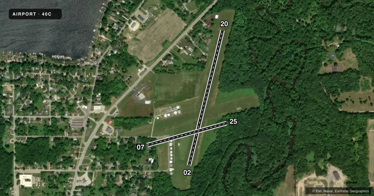
| 02/20 | 11° / 191° | 2,600 ft | TURF | Standard L |
| 07/25Favored | 71° / 251° | 1,540 ft | TURF | Standard L |
Runway end performance
| End | TORA | TODA | ASDA | LDA | VGSI | Approach lights | Obstruction |
|---|---|---|---|---|---|---|---|
| 02 | — | — | — | — | — | — | 70', trees, 50' from thr, 125' R of cntrln, slope 0 |
| 20 | — | — | — | — | — | — | 70', trees, 320' from thr, 125' R of cntrln, slope 4 |
| 07 | — | — | — | — | — | — | 69', trees, 345' from thr, 125' R of cntrln, slope 5 |
| 25 | — | — | — | — | — | — | 60', trees, 0' from thr, 120' R of cntrln, slope 0 |
Declared distances in feet. TORA = takeoff run available, TODA = takeoff distance, ASDA = accelerate-stop, LDA = landing distance.
Airport sketch
Runways drawn to scale from FAA survey coordinates, rendered over satellite imagery. Not for navigation.
Approaches & charts
Services on the field
Fuel grades, oxygen, maintenance, ramp storage and lighting — as declared to the FAA by the airport operator.
Fuel & services
- Fuel
- Not available
- Oxygen (bottled)
- Not available
- Oxygen (bulk)
- Not available
- Airframe repair
- Not available
- Power plant repair
- Not available
Ramp & ground
- Transient storage
- Tie-down
- Landing fee
- No fee published
- Customs
- Not available
- Lighting schedule
- SEE RMK
- Wind indicator
- Yes
- Segmented circle
- Yes
Fuel & FBOs
Cheapest 100LL and Jet A on the field and nearby. Always confirm with the FBO before taxi.
Airport notes
Surface conditions, obstructions, local procedures, lighting outages and other notes published with each FAA cycle.
General notes
- UAS, ULTRALIGHT, & PWRD PRCHT ACT.
- HOSP HLP 1 NM S.
- FOR CD CTC CHICAGO ARTCC AT 630-906-8921.
Lighting notes
- ACTVT MIRL RWY 02/20 - CTAF.
Runway surface & condition
- 07/25UNVERIFIED LDG AREA - CTC AMGR FOR DTLS.
Approach & departure obstructions
- 02RWY & DTHR MKD WITH 3 FT YELLOW CONES.
- 07DEFINED BY MOWING.
- 20RWY & DTHR MKD WITH 3 FT YELLOW CONES.
- 25DEFINED BY MOWING.
- 02APCH RATIO 9:1 TO DTHR OVR 70 FT TREES, 650 FT DIST, 125 FT R.
- 20APCH RATIO 4:1 TO DTHR OVR 98 FT TREES, 392 FT DIST, 165 FT L.
Other notes
- ESTABD BFR 1959.
- ROPES NOT PRVDD.
- MANAGERASST AMGR CELL 269-876-1536.
- 02/20SOFT WHEN WET & DURG SPRING DUE TO POOR DRAINAGE.
- 07/25SOFT WHEN WET & DURG SPRING DUE TO POOR DRAINAGE.
VFR map & nearby airports
VFR sectional. Tap any ICAO chip to open that airport.
Key facts · 40C
Answer card- ICAO
- 40C
- Name
- WATERVLIET MUNI
- Location
- WATERVLIET, MICHIGAN
- Elevation
- 656 ft MSL
- Traffic pattern altitude
- 1,656 ft MSL (1,000 AGL)
- Control tower
- Non-towered (use CTAF)
- Total runways
- 2
- Longest runway
- 02/20 · 2,600 ft
- Published ILS approaches
- 0
- Published frequencies
- 1
- Magnetic variation
- 3°
- Current flight rules
- VFR
- Current wind
- 230° at 5 kt
- Favored runway now
- RWY 25
Watervliet Muni sits in Watervliet, Michigan. The field elevation is 656 ft MSL. It has two turf runways. The longest is runway 02/20 at 2,600 ft. There is no control tower. CTAF is 122.9.
No ILS approaches are published here. Pattern altitude is not published, so use the standard 1,000 ft AGL for light piston traffic unless the current Chart Supplement says otherwise. That puts the pattern at 1,656 ft MSL based on the listed field elevation. Runway 02/20 is soft when wet and during spring because of poor drainage. Runway 02 and runway 20 both have 3-foot yellow cones marking the runway and displaced threshold. The runway 20 approach also has trees near the threshold area, so plan that side with care. Runway 07/25 is listed as unverified. Runway 25 is defined by mowing.
There are no on-field FBOs listed. Check with the airport manager before arrival if you need local support. Unmanned aircraft systems, ultralight aircraft and powered parachute activity also occur on the field. For clearance delivery, contact Chicago ARTCC at 630-906-8921. Medium intensity runway lights for 02/20 are activated by the CTAF.