METAR & TAF KBEH
Current METAR
Observed 04:53Z
KBEH 270453Z AUTO 19004KT 10SM CLR 24/22 A2986 RMK AO2 SLP105 T02440222 403000206
- Wind
- 190° @ 4 kt
- Visibility
- 10 SM
- Temp / Dew
- 24°C / 22°C
- Altimeter
- 29.86 inHg
- Clouds
- CLR
- Density alt
- 1,959 ft
- Ceiling
- Unlimited
- Rules
- VFR
Airport info & contacts
Manager on record, flight service, ARTCC, attendance schedule and pattern altitude — published by the FAA and refreshed every 28 days.
Location
- From city
- 2 NM NE
- VFR sectional
- CHICAGO
- ARTCC
- ZAU · CHICAGO
- NOTAM facility
- BEH (NOTAM-D)
Airport manager
- Name
- SHANNON CHRISTY
- Phone
- 269-486-1118
- Address
- 1123 TERRITORIAL RD, BENTON HARBOR MI 49022-2939
Flight service · Hours
- FSS LAN
- LANSING1-800-WX-BRIEF
- Attendance
- MON-FRI · 0800-1700
- SAT-SUN · ON CALL
Frequencies
Tap any row to copy the frequency to your clipboard.
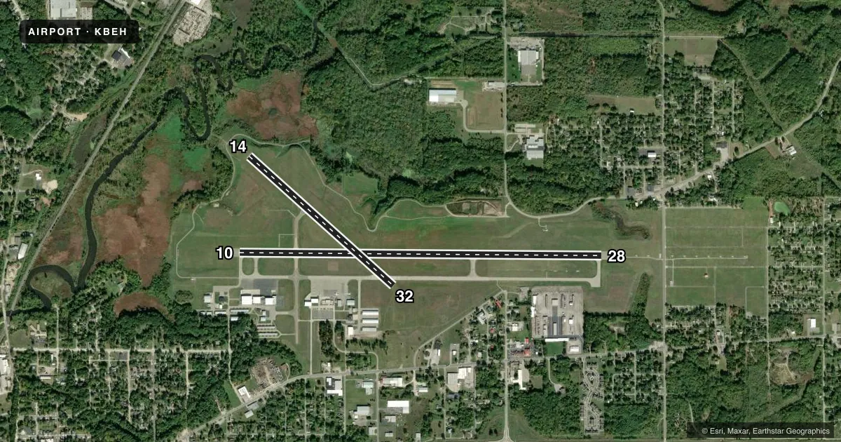
Runways & pattern
Full pagePattern entry · RWY 14
LEFT TRAFFIC| Runway | Heading (°M) | Length | Surface | Traffic |
|---|---|---|---|---|
| 10/28 | 86° / 266° | 6,006 ft | ASPH | Standard L |
| 14/32Favored | 128° / 308° | 3,205 ft | ASPH | Standard L |
Runway end performance
| End | TORA | TODA | ASDA | LDA | VGSI | Approach lights | Obstruction |
|---|---|---|---|---|---|---|---|
| 10 | — | — | — | — | PAPI 4-box left(3°) | — | 29', tree, 1160' from thr, 580' R of cntrln, slope 33 |
| 28 | — | — | — | — | PAPI 4-box left(3°) | MALSR | 82', tree, 3265' from thr, 963' R of cntrln, slope 37 |
| 14 | — | — | — | — | PAPI 2-box left(3.5°) | — | — |
| 32 | — | — | — | — | PAPI 2-box left(3.5°) | — | 67', tree, 1521' from thr, 279' R of cntrln, slope 19 |
Declared distances in feet. TORA = takeoff run available, TODA = takeoff distance, ASDA = accelerate-stop, LDA = landing distance.
Airport sketch
Runways drawn to scale from FAA survey coordinates, rendered over satellite imagery. Not for navigation.
Approaches & charts
ILS · 1
Services on the field
Fuel grades, oxygen, maintenance, ramp storage and lighting — as declared to the FAA by the airport operator.
Fuel & services
- Fuel
- 100LLA1+
- Oxygen (bottled)
- HIGH/LOW
- Oxygen (bulk)
- HIGH/LOW
- Airframe repair
- Major
- Power plant repair
- Major
Ramp & ground
- Transient storage
- Tie-down
- Hangar
- Landing fee
- Yes
- Customs
- Not available
- Lighting schedule
- SEE RMK
- Beacon schedule
- SS-SR
- Beacon
- White / Green (civil land)(WG)
- Wind indicator
- Lighted
- Segmented circle
- Yes
Fuel & FBOs
Cheapest 100LL and Jet A on the field and nearby. Always confirm with the FBO before taxi.
Airport notes
Surface conditions, obstructions, local procedures, lighting outages and other notes published with each FAA cycle.
General notes
- DEER & LRG BIRDS ON & INVOF ARPT.
- RWY 14 DROP OFF 300 FT FM THR.
- SNOW REMOVAL OPS DURG WINTER MONTHS, VEHICLE OPRS MNT CTAF.
- FOR FICONS CALL ASST AMGR AT 269-369-2213; UNMON AFT HRS.
- FOR CD IF UNA VIA FREQ CTC SOUTH BEND APCH AT 574-251-2609. WHEN SOUTH BEND APCH CLSD, FOR CD CTC CHICAGO ARTCC AT 630-906-8921.
Lighting notes
- ACTVT MALSR RWY 28; REIL RWY 10, 14, & 32; PAPI RWY 10, 28, 14, & 32; HIRL RWY 10/28; MIRL RWY 14/32 - CTAF.
Fuel notes
- 100LLAVBL H24 SELF SVC & FULL SVC DURG ATNDD HRS.
Other notes
- LDG FEE FOR ALL COML OPS & ALL TURBINE PWRD ACFT; FAC FEE FOR ALL MULT ENG & COML SNGL ENG ACFT WAIVED WITH MNM FUEL PURCHASE.
- MAX SIZE ACFT HAWKER 800.
- 21UNATNDD MAJOR HOLS. WKENDS & AFT HRS SVC BY REQ & SUBJ CALL-IN FEE - CALL 269-925-5114 DURG BUS HRS.
- MANAGEREXTN 10; CELL 269-921-9200.
VFR map & nearby airports
VFR sectional. Tap any ICAO chip to open that airport.
Key facts · KBEH
Answer card- ICAO
- KBEH
- Name
- SOUTHWEST MICHIGAN RGNL
- Location
- BENTON HARBOR, MICHIGAN
- Elevation
- 649.1 ft MSL
- Traffic pattern altitude
- 1,649.1 ft MSL (1,000 AGL)
- Control tower
- Non-towered (use CTAF)
- Total runways
- 2
- Longest runway
- 10/28 · 6,006 ft
- Published ILS approaches
- 1
- Published frequencies
- 5
- Magnetic variation
- 4°
- Current flight rules
- VFR
- Current wind
- 190° at 4 kt
- Favored runway now
- RWY 14
Southwest Michigan Rgnl sits in Benton Harbor, Michigan. The field elevation is 649.1 ft MSL. It has two asphalt runways. The longest is runway 10/28 at 6,006 ft. Runway 14/32 is 3,205 ft. There is no control tower, so plan for CTAF traffic and self-announce work. Pattern altitude is not published. Use the standard 1,000 ft AGL for light piston aircraft unless the current Chart Supplement says otherwise.
Runway 28 has an ILS. That is the only published ILS approach at the field. Lighting is well covered. MALSR is on runway 28. REIL is available on 10, 14 and 32. PAPI is available on all runway ends. HIRL is on 10/28. MIRL is on 14/32. The lights are monitored on CTAF.
Skyway Aviation is on the field. It carries 100LL and Jet A Prist. 100LL is available 24 hours self-serve. Full service is available during attended hours. The airport can be busy with winter snow removal operations. Deer and large birds are reported on and near the field. Runway 14 has a drop off about 300 ft from the threshold. For a first visit, brief the runway 28 ILS. Watch the wildlife. Check the current Chart Supplement for any operational notes before you go.