METAR & TAF C20
C20 does not publish a METAR.
Showing the nearest reporting station: KBEH (SOUTHWEST MICHIGAN RGNL) · 10.9 NM away. Conditions at C20 may differ.
METAR · KBEH
Observed 09:15Z
KBEH 270915Z AUTO 15003KT 8SM FEW019 SCT025 BKN035 23/23 A2986 RMK AO2 T02330228
- Wind
- 150° @ 3 kt
- Visibility
- 8 SM
- Temp / Dew
- 23°C / 23°C
- Altimeter
- 29.86 inHg
- Clouds
- BKN
- Density alt
- 1,870 ft
- Ceiling
- 3,500 ft AGL
- Rules
- VFR
Airport info & contacts
Manager on record, flight service, ARTCC, attendance schedule and pattern altitude — published by the FAA and refreshed every 28 days.
Location
- From city
- 1 NM W
- VFR sectional
- CHICAGO
- Pattern altitude
- 1,032 ft AGL · 1,706 ft MSL
- ARTCC
- ZAU · CHICAGO
- NOTAM facility
- LAN (NOTAM-D)
Airport manager
- Name
- ANGELO GRANT
- Phone
- 269-471-3265
- Address
- 3898 GRIGGS AVE, BERRIEN SPRINGS MI 49103-1675
Flight service · Hours
- FSS LAN
- LANSING1-800-WX-BRIEF
- Attendance
- MON-THUR · 0800-1700
- FRI · 0800-1500
Frequencies
Tap any row to copy the frequency to your clipboard.
Runways & pattern
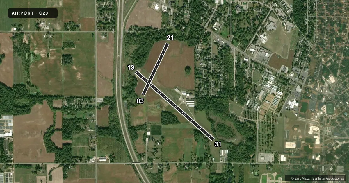
Full pagePattern entry · RWY 13
RIGHT TRAFFIC| Runway | Heading (°M) | Length | Surface | Traffic |
|---|---|---|---|---|
| 13/31Favored | 128° / 308° | 4,148 ft | ASPH | 13 R |
| 03/21 | 23° / 203° | 2,298 ft | TURF | 21 R |
Runway end performance
| End | TORA | TODA | ASDA | LDA | VGSI | Approach lights | Obstruction |
|---|---|---|---|---|---|---|---|
| 13 | — | — | — | — | — | — | 70', trees, 200' from thr, 200' R of cntrln, slope 0 |
| 31 | — | — | — | — | — | — | 30', trees, 230' from thr, 188' R of cntrln, slope 1 |
| 03 | — | — | — | — | — | — | 100', trees, 300' from thr, 0' R of cntrln, slope 3 |
| 21 | — | — | — | — | — | — | 76', trees, 188' from thr, 0' R of cntrln, slope 0 |
Declared distances in feet. TORA = takeoff run available, TODA = takeoff distance, ASDA = accelerate-stop, LDA = landing distance.
Airport sketch
Runways drawn to scale from FAA survey coordinates, rendered over satellite imagery. Not for navigation.
Approaches & charts
Services on the field
Fuel grades, oxygen, maintenance, ramp storage and lighting — as declared to the FAA by the airport operator.
Fuel & services
- Fuel
- 100LL
- Oxygen (bottled)
- Not available
- Other services
- INSTR
Ramp & ground
- Transient storage
- Tie-down
- Hangar
- Landing fee
- No fee published
- Lighting schedule
- SEE RMK
- Beacon schedule
- SS-SR
- Beacon
- White / Green (civil land)(WG)
- Wind indicator
- Yes
- Segmented circle
- Yes
Fuel & FBOs
Cheapest 100LL and Jet A on the field and nearby. Always confirm with the FBO before taxi.
Airport notes
Surface conditions, obstructions, local procedures, lighting outages and other notes published with each FAA cycle.
General notes
- ADMIN BLDG ACES: PRESS V, THEN III & II SIMUL, THEN I.
- DEER, BIRDS, & WILDLIFE ON & INVOF ARPT.
- RWY 13/31: 25 FT DROP OFF, 55 FT DIST FM NW END; 15 FT DROP OFF, 0-400 FT DIST FM SE END.
- FOR CD CTC SOUTH BEND APCH AT 574-251-2609, WHEN APCH CLSD CTC CHICAGO ARTCC AT 630-906-8921.
Lighting notes
- ACTVT NSTD LIRL RWY 13/31 - CTAF.
Fuel notes
- 100LLAVBL H24 SELF SVC.
Runway surface & condition
- 13/31NSTD LIRL DUE TO THR LGTS IMPROPER COLOR & UNINSTLD/MISG FIXTURES.
Approach & departure obstructions
- 13+70 FT TREES, 0 FT DIST, 153 FT R; +70 FT TREES, 50 FT DIST, 170 FT L.
- 31+7 FT TREES & SHRUBS, 0-199 FT DIST, 90 FT R.
- 13CTLG OBSTN EXCEEDS A 45 DEG SLP. +70 FT TREE, 200 FT DIST, 200FT L.
- 21+76 FT TREES, 188 FT DIST, 0 FT L/R.
- 31APCH RATIO 5:1 TO DTHR OVR +120 FT TREES, 600 FT DIST, 125 FT L.
- 1380 FT PLINE, 1855 FT DIST, 290 FT R.
Other notes
- CALL AHD FOR HNGR STORAGE.
VFR map & nearby airports
VFR sectional. Tap any ICAO chip to open that airport.
Key facts · C20
Answer card- ICAO
- C20
- Name
- ANDREWS UNIVERSITY AIRPARK
- Location
- BERRIEN SPRINGS, MICHIGAN
- Elevation
- 673.7 ft MSL
- Traffic pattern altitude
- 1,705.7 ft MSL (1,032 AGL)
- Control tower
- Non-towered (use CTAF)
- Total runways
- 2
- Longest runway
- 13/31 · 4,148 ft
- Published ILS approaches
- 0
- Published frequencies
- 4
- Magnetic variation
- 3°
- Current flight rules
- VFR
- Current wind
- 150° at 3 kt
- Favored runway now
- RWY 13
Andrews University Airpark sits in Berrien Springs, Michigan. Field elevation is 673.7 ft MSL. The airport has two runways. The longest is 13/31 at 4,148 ft. Runway 03/21 is 2,298 ft turf. There is no control tower. Pattern altitude is 1,705.7 ft MSL, which is 1,032 ft AGL.
No ILS approaches are published here. Use the current FAA Chart Supplement for approach and airport details before you go. The on-field FBO is Andrews University Airport. It carries 100LL. 100LL is also available 24 hours a day by self-serve. Published remarks note nonstandard low-intensity runway lights on 13/31. The displaced threshold on runway 13 is unlighted. The lights on 13/31 are activated by CTAF.
First-time pilots should pay close attention to runway 13/31. Published remarks call out drop-offs near both ends, plus obstructions near runway 13 and near the displaced threshold on runway 31. There is also an unverified landing area northwest of the primary runway. Contact the airport manager for details. Clearance delivery is handled through South Bend Approach when available. If approach is closed, contact Chicago ARTCC. Call ahead for hangar storage. Check the current Chart Supplement for any published noise or curfew restrictions before flying into the field.