METAR & TAF KRWN
KRWN does not publish a METAR.
Showing the nearest reporting station: KOXI (STARKE COUNTY) · 14.4 NM away. Conditions at KRWN may differ.
METAR · KOXI
Observed 10:55Z
KOXI 271055Z AUTO 12002KT M1/4SM FG OVC002 22/22 A2990 RMK AO2
- Wind
- 120° @ 2 kt
- Visibility
- —
- Temp / Dew
- 22°C / 22°C
- Altimeter
- 29.90 inHg
- Clouds
- OVC
- Density alt
- 1,743 ft
- Ceiling
- 200 ft AGL
- Rules
- LIFR
Airport info & contacts
Manager on record, flight service, ARTCC, attendance schedule and pattern altitude — published by the FAA and refreshed every 28 days.
Location
- From city
- 3 NM N
- VFR sectional
- CHICAGO
- ARTCC
- ZAU · CHICAGO
- NOTAM facility
- HUF (NOTAM-D)
Airport manager
- Name
- DARYN WILDER
- Phone
- 574-946-6785
- Address
- 2595 N. US 35, WINAMAC IN 46996
Flight service · Hours
- FSS HUF
- TERRE HAUTE1-800-WX-BRIEF
- Attendance
- MON-FRI · 0900-1700
Frequencies
Tap any row to copy the frequency to your clipboard.
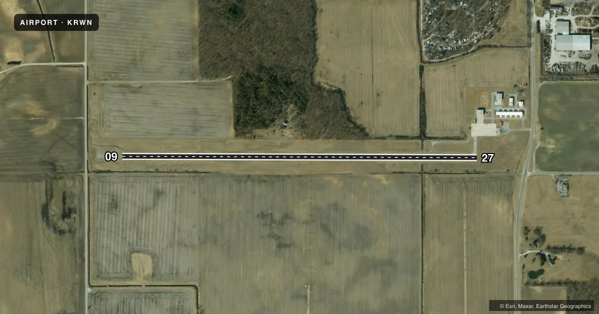
Runways & pattern
Full pagePattern entry · RWY 09
LEFT TRAFFICRunway end performance
| End | TORA | TODA | ASDA | LDA | VGSI | Approach lights | Obstruction |
|---|---|---|---|---|---|---|---|
| 09 | — | — | — | — | PAPI 2-box left(3°) | — | 10', road, 430' from thr, 0' R of cntrln, slope 23 |
| 27 | — | — | — | — | PAPI 2-box left(3.5°) | — | 26', tree, 350' from thr, 170' R of cntrln, slope 5 |
Declared distances in feet. TORA = takeoff run available, TODA = takeoff distance, ASDA = accelerate-stop, LDA = landing distance.
Airport sketch
Runways drawn to scale from FAA survey coordinates, rendered over satellite imagery. Not for navigation.
Approaches & charts
Services on the field
Fuel grades, oxygen, maintenance, ramp storage and lighting — as declared to the FAA by the airport operator.
Fuel & services
- Fuel
- 100LLA
- Oxygen (bottled)
- Not available
- Oxygen (bulk)
- Not available
- Airframe repair
- Not available
- Power plant repair
- Not available
Ramp & ground
- Transient storage
- Tie-down
- Hangar
- Landing fee
- No fee published
- Customs
- Not available
- Lighting schedule
- SEE RMK
- Wind indicator
- Lighted
- Segmented circle
- No
Fuel & FBOs
Cheapest 100LL and Jet A on the field and nearby. Always confirm with the FBO before taxi.
Airport notes
Surface conditions, obstructions, local procedures, lighting outages and other notes published with each FAA cycle.
General notes
- FOR CD CTC SOUTH BEND APCH AT 574-251-2609. WHEN SOUTH BEND APCH CLSD, FOR CD CTC CHICAGO ARTCC AT 630-906-8921.
Lighting notes
- ACTVT REIL RWY 09 & 27; PAPI RWY 09 & 27; MIRL RWY 09/27 - CTAF.
Fuel notes
- ASELF SERVICE.
Runway surface & condition
- 09/27EST SINGLE WHEEL PAVEMENT STRENGTH 12000 LBS.
- 09/27300 FT STWY ON WEST END.
Approach & departure obstructions
- 094 FT FENCE 200 FT N.
- 09REIL OTS INDEFLY.
- 0935:1 CLEARANCE SLOPE TO DISPLACED THRESHOLD
Other notes
- OWNERJIM MCDANIEL.
VFR map & nearby airports
VFR sectional. Tap any ICAO chip to open that airport.
Key facts · KRWN
Answer card- ICAO
- KRWN
- Name
- ARENS FLD
- Location
- WINAMAC, INDIANA
- Elevation
- 708.3 ft MSL
- Traffic pattern altitude
- 1,708.3 ft MSL (1,000 AGL)
- Control tower
- Non-towered (use CTAF)
- Total runways
- 1
- Longest runway
- 09/27 · 4,201 ft
- Published ILS approaches
- 0
- Published frequencies
- 4
- Magnetic variation
- 3°
- Current flight rules
- LIFR
- Current wind
- 120° at 2 kt
- Favored runway now
- RWY 09
Arens Fld sits in Winamac, Indiana. Field elevation is 708.3 ft MSL. The airport has one runway, 09/27, which is 4,201 ft long. There is no control tower. No ILS approaches are published here. Pattern altitude is not published, so use the standard 1,000 ft AGL for light piston traffic unless the current Chart Supplement says otherwise.
The on-field FBO is Arens Field. It carries 100LL and Jet A. Self-serve fuel is available. The field uses CTAF 122.8. For clearance delivery, contact South Bend Approach. When South Bend Approach is closed, use Chicago ARTCC for clearance delivery. The runway has medium intensity lighting. REILs and PAPI are installed on 09 and 27. The west end also has a 300 ft stopway. One operational note for runway 09. REILs on 09 are out of service indefinitely. There is also a 4 ft fence 200 ft north of runway 09, so keep that in mind on approach.
For a first-time arrival, the main things are the single runway layout, the lack of tower service and the published lighting details. The runway strength is listed at 12,000 lb single wheel on 09/27. Check the current Chart Supplement for any updated remarks before you go.