METAR & TAF KTEL
KTEL does not publish a METAR.
Showing the nearest reporting station: KHNB (HUNTINGBURG) · 18.5 NM away. Conditions at KTEL may differ.
METAR · KHNB
Observed 10:03Z
KHNB 271003Z AUTO 27006KT 10SM SCT006 22/22 A2992 RMK AO2
- Wind
- 270° @ 6 kt
- Visibility
- 10 SM
- Temp / Dew
- 22°C / 22°C
- Altimeter
- 29.92 inHg
- Clouds
- SCT
- Density alt
- 1,658 ft
- Ceiling
- Unlimited
- Rules
- VFR
Airport info & contacts
Manager on record, flight service, ARTCC, attendance schedule and pattern altitude — published by the FAA and refreshed every 28 days.
Location
- From city
- 6 NM NE
- VFR sectional
- ST LOUIS
- ARTCC
- ZID · INDIANAPOLIS
- NOTAM facility
- HUF (NOTAM-D)
Airport manager
- Name
- KEN ROLAND
- Phone
- 812-608-0651
- Address
- 11965 OLD STATE RD 37, TELL CITY IN 47586
Flight service · Hours
- FSS HUF
- TERRE HAUTE1-800-WX-BRIEF
- Attendance
- Unattended
Frequencies
Tap any row to copy the frequency to your clipboard.
Runways & pattern
Full pagePattern entry · RWY 31
LEFT TRAFFICRunway end performance
| End | TORA | TODA | ASDA | LDA | VGSI | Approach lights | Obstruction |
|---|---|---|---|---|---|---|---|
| 13 | — | — | — | — | PAPI 4-box right(3°) | — | 20', trees, 370' from thr, 60' R of cntrln, slope 8 |
| 31 | — | — | — | — | PAPI 4-box right(3.25°) | — | 43', tree, 680' from thr, 110' R of cntrln, slope 11 |
Declared distances in feet. TORA = takeoff run available, TODA = takeoff distance, ASDA = accelerate-stop, LDA = landing distance.
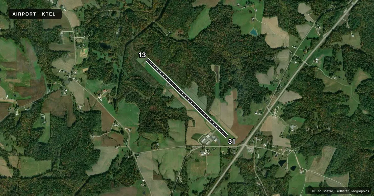
Airport sketch
Runways drawn to scale from FAA survey coordinates, rendered over satellite imagery. Not for navigation.
Approaches & charts
Services on the field
Fuel grades, oxygen, maintenance, ramp storage and lighting — as declared to the FAA by the airport operator.
Fuel & services
- Fuel
- 100LLMOGAS
- Oxygen (bulk)
- Not available
Ramp & ground
- Transient storage
- Tie-down
- Hangar
- Landing fee
- No fee published
- Customs
- Not available
- Lighting schedule
- SEE RMK
- Beacon schedule
- SS-SR
- Beacon
- White / Green (civil land)(WG)
- Wind indicator
- Lighted
- Segmented circle
- No
Fuel & FBOs
Cheapest 100LL and Jet A on the field and nearby. Always confirm with the FBO before taxi.
Airport notes
Surface conditions, obstructions, local procedures, lighting outages and other notes published with each FAA cycle.
General notes
- SAWRS
- FOR CD CTC EVANSVILLE APCH AT 812-436-4690, WHEN APCH CLSD CTC INDIANAPOLIS ARTCC AT 317-247-2411.
- SELF SERV FUEL AVBL.
Lighting notes
- ACTVT REIL RWY 13 & 31; MIRL RWY 13/31 - CTAF. PAPI RWY 13 & 31 H24.
Approach & departure obstructions
- 13TREES 15-20' TALL 100' L OF CENTERLINE
- 31CROPS 5FT TALL AT 170FT R OF CL
- 13CLNC SLOPE 15:1 AT THLD
VFR map & nearby airports
VFR sectional. Tap any ICAO chip to open that airport.
Key facts · KTEL
Answer card- ICAO
- KTEL
- Name
- PERRY COUNTY MUNI
- Location
- TELL CITY, INDIANA
- Elevation
- 659.5 ft MSL
- Traffic pattern altitude
- 1,659.5 ft MSL (1,000 AGL)
- Control tower
- Non-towered (use CTAF)
- Total runways
- 1
- Longest runway
- 13/31 · 4,400 ft
- Published ILS approaches
- 0
- Published frequencies
- 4
- Magnetic variation
- 2°
- Current flight rules
- VFR
- Current wind
- 270° at 6 kt
- Favored runway now
- RWY 31
Perry County Muni sits in Tell City, Indiana. The field elevation is 659.5 ft MSL. It has one runway. Runway 13/31 is 4,400 ft of asphalt, which is the longest runway on the field. There is no control tower. CTAF and UNICOM are both 122.7. Approach and departure service is through Evansville on 124.025 or 290.9. If Approach is closed, clearance delivery goes through Indianapolis ARTCC.
No ILS approaches are published here. The published pattern altitude is not listed, so use the standard 1,000 ft AGL for light piston operations unless the current Chart Supplement says otherwise. The on-field FBO is Perry Count Airport Authority. It carries 100LL and MOGAS. Self-service fuel is available.
A few remarks matter on a first visit. Runway end identifier lights are installed on 13 and 31. Medium intensity runway lights on 13/31 are controlled by CTAF. PAPI is available on both runway ends all day. Watch the published obstructions near both ends. There are crops 170 ft right of centerline near runway 31. Trees 100 ft left of centerline near runway 13. The threshold of runway 13 also has a 15 to 1 clearance slope note. This is a good field to brief before arrival, especially if you are planning a night or low-visibility approach.