METAR & TAF IN3
IN3 does not publish a METAR.
Showing the nearest reporting station: KEHR (HENDERSON CITY-COUNTY) · 7.6 NM away. Conditions at IN3 may differ.
METAR · KEHR
Observed 12:56Z
KEHR 251256Z AUTO 00000KT 10SM OVC055 22/18 A3008 RMK AO2 SLP184 T02170183 $
- Wind
- 000° @ 0 kt
- Visibility
- 10 SM
- Temp / Dew
- 22°C / 18°C
- Altimeter
- 30.08 inHg
- Clouds
- OVC
- Density alt
- 1,105 ft
- Ceiling
- 5,500 ft AGL
- Rules
- VFR
Airport info & contacts
Manager on record, flight service, ARTCC, attendance schedule and pattern altitude — published by the FAA and refreshed every 28 days.
Location
- From city
- 3 NM W
- VFR sectional
- ST LOUIS
- ARTCC
- ZID · INDIANAPOLIS
- NOTAM facility
- HUF (NOTAM-D)
Airport manager
- Name
- TOM SMITH
- Phone
- (972) 365-2301
- Address
- 9230 CABORN RD S, MT VERNON IN 47620-8557
Flight service · Hours
- FSS HUF
- TERRE HAUTE1-800-WX-BRIEF
- Attendance
- Unattended
Frequencies
Tap any row to copy the frequency to your clipboard.
Runways & pattern
Full pagePattern entry · RWY 09
RIGHT TRAFFICRunway end performance
| End | TORA | TODA | ASDA | LDA | VGSI | Approach lights | Obstruction |
|---|---|---|---|---|---|---|---|
| 27 | — | — | — | — | — | — | 10', crops, 15' from thr, 0' R of cntrln, slope 1 |
Declared distances in feet. TORA = takeoff run available, TODA = takeoff distance, ASDA = accelerate-stop, LDA = landing distance.
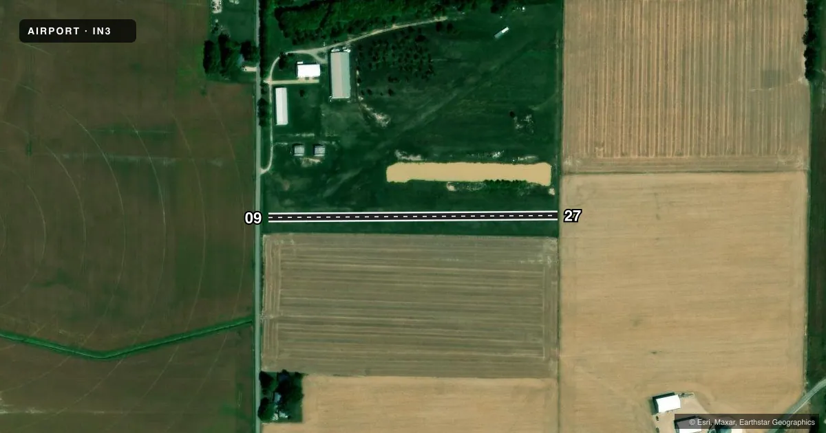
Airport sketch
Runways drawn to scale from FAA survey coordinates, rendered over satellite imagery. Not for navigation.
Approaches & charts
Services on the field
Fuel grades, oxygen, maintenance, ramp storage and lighting — as declared to the FAA by the airport operator.
Fuel & services
- Fuel
- Not available
Ramp & ground
- Transient storage
- Not published
- Wind indicator
- Yes
- Segmented circle
- No
Fuel & FBOs
Cheapest 100LL and Jet A on the field and nearby. Always confirm with the FBO before taxi.
Airport notes
Surface conditions, obstructions, local procedures, lighting outages and other notes published with each FAA cycle.
General notes
- FOR CD CTC EVANSVILLE APCH AT 812-436-4690, WHEN APCH CLSD CTC INDIANAPOLIS ARTCC AT 317-247-2411.
Runway surface & condition
- 05/23CLSD INDEFLY.
Other notes
- PRVDD NEW RY THR LOCATED IN ACCORDANCE WITH AIRSPACE LTR 84-AGL-377-NRA; ULTRALGTS ONLY.
VFR map & nearby airports
VFR sectional. Tap any ICAO chip to open that airport.
Key facts · IN3
Answer card- ICAO
- IN3
- Name
- POSEY PATCH
- Location
- MOUNT VERNON, INDIANA
- Elevation
- 374 ft MSL
- Traffic pattern altitude
- 1,374 ft MSL (1,000 AGL)
- Control tower
- Non-towered (use CTAF)
- Total runways
- 1
- Longest runway
- 09/27 · 1,300 ft
- Published ILS approaches
- 0
- Published frequencies
- 0
- Magnetic variation
- 0°
- Current flight rules
- VFR
- Current wind
- 000° at 0 kt
- Favored runway now
- –
Posey Patch (IN3) is in Mount Vernon, Indiana. Field elevation is 374 ft MSL. It has one runway. Runway 09/27 is 1,300 ft long and surfaced turf-dirt. The runway headings are magnetic 090° and 270°. Runway 05/23 is closed indefinitely, so plan around the published 09/27 strip only.
This is an uncontrolled field with no control tower. No ILS approaches are published. Pattern altitude is not published in the facts, so use the standard 1,000 ft AGL reference for light piston traffic. That puts the pattern at 1,374 ft MSL based on the listed field elevation. The airport remarks also note that the new runway threshold was placed under airspace letter 84-AGL-377-NRA. Ultralights only are mentioned in that note, so verify current use and access before you go.
There are no on-field FBOs listed in the facts. Contact the airport operator directly before arrival if you need fuel or ground handling. For clearance delivery, contact Evansville Approach at 812-436-4690. If approach is closed, contact Indianapolis ARTCC at 317-247-2411. With a short turf-dirt runway and no published ILS, this is a field where a pilot should plan conservatively and verify current conditions before departure.