METAR & TAF KCRZ
KCRZ does not publish a METAR.
Showing the nearest reporting station: KCSQ (CRESTON MUNI) · 17.8 NM away. Conditions at KCRZ may differ.
METAR · KCSQ
Observed 20:15Z
KCSQ 272015Z AUTO 27004KT 9SM FEW028 SCT065 BKN120 27/26 A2980 RMK AO2
- Wind
- 270° @ 4 kt
- Visibility
- 9 SM
- Temp / Dew
- 27°C / 26°C
- Altimeter
- 29.80 inHg
- Clouds
- BKN
- Density alt
- 3,169 ft
- Ceiling
- 12,000 ft AGL
- Rules
- VFR
Airport info & contacts
Manager on record, flight service, ARTCC, attendance schedule and pattern altitude — published by the FAA and refreshed every 28 days.
Location
- From city
- 1 NM W
- VFR sectional
- OMAHA
- ARTCC
- ZMP · MINNEAPOLIS
- NOTAM facility
- FOD (NOTAM-D)
Airport manager
- Name
- WAYNE PAGE
- Phone
- 515-491-5508
- Address
- 601 6TH, CORNING IA 50841
Flight service · Hours
- FSS FOD
- FORT DODGE1-800-WX-BRIEF
- Attendance
- Unattended
Frequencies
Tap any row to copy the frequency to your clipboard.
Runways & pattern
Full pagePattern entry · RWY 18
RIGHT TRAFFICRunway end performance
| End | TORA | TODA | ASDA | LDA | VGSI | Approach lights | Obstruction |
|---|---|---|---|---|---|---|---|
| 18 | — | — | — | — | — | — | 40', tree, 1074' from thr, 194' R of cntrln, slope 21 |
Declared distances in feet. TORA = takeoff run available, TODA = takeoff distance, ASDA = accelerate-stop, LDA = landing distance.
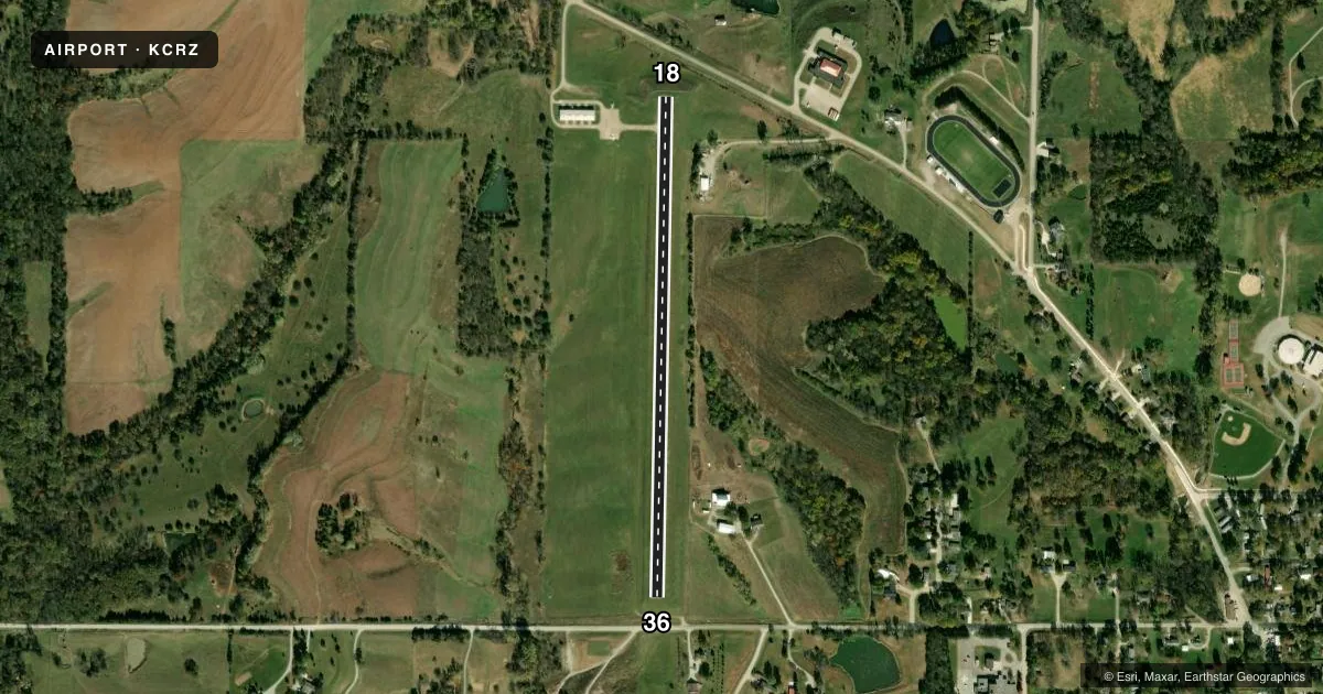
Airport sketch
Runways drawn to scale from FAA survey coordinates, rendered over satellite imagery. Not for navigation.
Approaches & charts
Services on the field
Fuel grades, oxygen, maintenance, ramp storage and lighting — as declared to the FAA by the airport operator.
Fuel & services
- Fuel
- 100LL
- Oxygen (bottled)
- Not available
- Oxygen (bulk)
- Not available
- Airframe repair
- Not available
- Power plant repair
- Not available
Ramp & ground
- Transient storage
- Tie-down
- Landing fee
- No fee published
- Lighting schedule
- SEE RMK
- Beacon schedule
- SS-SR
- Beacon
- White / Green (civil land)(WG)
- Wind indicator
- Lighted
- Segmented circle
- No
Fuel & FBOs
Cheapest 100LL and Jet A on the field and nearby. Always confirm with the FBO before taxi.
Airport notes
Surface conditions, obstructions, local procedures, lighting outages and other notes published with each FAA cycle.
General notes
- CTN: SHARP DROP BOTH ENDS RWY 18/36.
- DEER INVOF ARPT.
- SNOW REMOVAL OPS DURG WINT MONTHS VIA CITY OF CORNING AT 641-322-4230. AFT HRS CALL 515-491-5508.
- FOR CD CTC MINNEAPOLIS ARTCC AT 651-463-5588.
Lighting notes
- ACTVT MIRL RWY 18/36 - 122.9.
Fuel notes
- 100LLSELF SERVICE FUEL AVBL 24 HOURS WITH CREDIT CARD
Other notes
- THIS AIRPORT HAS BEEN SURVEYED BY THE NATIONAL GEODETIC SURVEY.
- ESTABLISHED PRIOR TO 1959.
VFR map & nearby airports
VFR sectional. Tap any ICAO chip to open that airport.
Key facts · KCRZ
Answer card- ICAO
- KCRZ
- Name
- CORNING MUNI
- Location
- CORNING, IOWA
- Elevation
- 1,274 ft MSL
- Traffic pattern altitude
- 2,274 ft MSL (1,000 AGL)
- Control tower
- Non-towered (use CTAF)
- Total runways
- 1
- Longest runway
- 18/36 · 2,684 ft
- Published ILS approaches
- 0
- Published frequencies
- 1
- Magnetic variation
- 4°
- Current flight rules
- VFR
- Current wind
- 270° at 4 kt
- Favored runway now
- RWY 18
Corning Muni sits in Corning, Iowa. Field elevation is 1,274 ft MSL. The airport has one runway. Runway 18/36 is 2,684 ft long with a concrete surface. There is no control tower. CTAF is 122.9. No ILS approaches are published here.
Pattern altitude is not published. Use standard 1,000 ft AGL for light piston traffic unless the current Chart Supplement says otherwise. The field has a single on-field FBO listed as Corning Municipal Airport. It carries 100LL. Self-serve fuel is available 24 hours with credit card. The runway lights on 18/36 are medium intensity. They are activated on 122.9.
Plan for a few local cautions. There is a sharp drop at both ends of runway 18/36. Deer are also in the vicinity. The airport was established before 1959. For clearance delivery, contact Minneapolis ARTCC at 651-463-5588. Winter snow removal is handled by the City of Corning. If you are arriving in marginal conditions or at night, brief the runway length, the drop-offs and the lighting activation before you taxi in.