METAR & TAF KSLC
Current METAR
Observed 14:54Z
KSLC 271454Z 15011KT 10SM BKN150 32/12 A3003 RMK AO2 SLP092 T03220117 51010 $
- Wind
- 150° @ 11 kt
- Visibility
- 10 SM
- Temp / Dew
- 32°C / 12°C
- Altimeter
- 30.03 inHg
- Clouds
- BKN
- Density alt
- 7,150 ft
- Ceiling
- 15,000 ft AGL
- Rules
- VFR
Airport info & contacts
Manager on record, flight service, ARTCC, attendance schedule and pattern altitude — published by the FAA and refreshed every 28 days.
Location
- From city
- 3 NM W
- VFR sectional
- SALT LAKE CITY
- ARTCC
- ZLC · SALT LAKE CITY
- NOTAM facility
- SLC (NOTAM-D)
Airport manager
- Name
- MATTHEW BROWN
- Phone
- 801-575-2460
- Address
- P.O. BOX 145550, SALT LAKE CITY UT 84114-5550
Flight service · Hours
- FSS CDC
- CEDAR CITY1-800-WX-BRIEF
- Attendance
- ALL
Frequencies
Tap any row to copy the frequency to your clipboard.
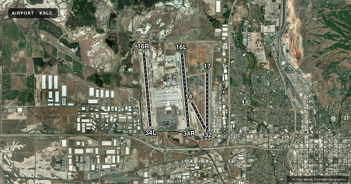
Runways & pattern
Full pagePattern entry · RWY 14
LEFT TRAFFIC| Runway | Heading (°M) | Length | Surface | Traffic |
|---|---|---|---|---|
| 16L/34R | 164° / 344° | 12,002 ft | ASPH | Standard L |
| 16R/34L | 164° / 344° | 12,000 ft | CONC | Standard L |
| 17/35 | 169° / 349° | 9,596 ft | ASPH | Standard L |
| 14/32Favored | 142° / 322° | 4,893 ft | ASPH | Standard L |
Runway end performance
| End | TORA | TODA | ASDA | LDA | VGSI | Approach lights | Obstruction |
|---|---|---|---|---|---|---|---|
| 16L | 12,002' | 12,002' | 12,002' | 12,002' | PAPI 4-box left(3°) | ALSF2 | — |
| 34R | 12,002' | 12,002' | 12,002' | 12,002' | PAPI 4-box left(3°) | ALSF2 | — |
| 16R | 12,000' | 12,000' | 12,000' | 12,000' | PAPI 4-box left(3°) | ALSF2 | — |
| 34L | 12,000' | 12,000' | 12,000' | 12,000' | PAPI 4-box left(3°) | ALSF2 | — |
| 17 | 9,596' | 9,596' | 9,596' | 9,596' | PAPI 4-box right(3°) | MALSR | — |
| 35 | 9,596' | 9,596' | 9,596' | 9,272' | PAPI 4-box left(3°) | MALSR | 24', ant, 1005' from thr, 250' R of cntrln, slope 33 |
| 14 | 4,893' | 4,893' | 4,893' | 4,893' | PAPI 4-box left(3°) | — | — |
| 32 | 4,893' | 4,893' | 4,893' | 4,893' | PAPI 4-box left(3°) | — | — |
Declared distances in feet. TORA = takeoff run available, TODA = takeoff distance, ASDA = accelerate-stop, LDA = landing distance.
Airport sketch
Runways drawn to scale from FAA survey coordinates, rendered over satellite imagery. Not for navigation.
Approaches & charts
ILS · 6
Services on the field
Fuel grades, oxygen, maintenance, ramp storage and lighting — as declared to the FAA by the airport operator.
Fuel & services
- Fuel
- 100LLA++A1+
- Oxygen (bottled)
- HIGH/LOW
- Oxygen (bulk)
- HIGH/LOW
- Airframe repair
- Major
- Power plant repair
- Major
- Other services
- AFRT,AMB,AVNCS,CARGO,CHTR,INSTR,RNTL,SALES
Ramp & ground
- Transient storage
- Tie-down
- Hangar
- Landing fee
- No fee published
- Customs
- Not available
- Lighting schedule
- SS-SR
- Beacon schedule
- SS-SR
- Beacon
- White / Green (civil land)(WG)
- Wind indicator
- Lighted
- Segmented circle
- No
Fuel & FBOs
Cheapest 100LL and Jet A on the field and nearby. Always confirm with the FBO before taxi.
Airport notes
Surface conditions, obstructions, local procedures, lighting outages and other notes published with each FAA cycle.
General notes
- FLOCK OF BIRDS ON AND IN VICINITY OF ARPT.
- HELIPADS B AND F LOCATED ON GENERAL AVIATION APRONS.
- SURFACE MOVEMENT GUIDANCE CONTROL SYSTEM & LOW VISIBILITY TAXI PROCEDURES.
- DUE TO TFC VOL, LCL DEPARTURE AND ARR OPNS ARE DISCOURAGED AND DLAS CAN BE EXPCD BTN 1500-1730Z++ AND 0130-0300Z++.
- SVFR IS NOT RCMD AT THE ARPT, IF REQD, EXPT DLAS.
- MILITARY: ANG RAMP: OPR 1430-2230Z++ MON-THU. CLSD FRI-SUN AND HOL. OFFL BUS ONLY. PPR REQ 48 HR ALL ACFT, VALID 1 HR +/- ETA. TRAN PRK/SVC EXTREMELY LTD. BASE OPS DSN 245-2274, C801-245-2274. MIL ALT HILL AFB (KHIF) 25 NM N. ALL ACFT CTC HIVE CTL (COMD POST) 20 MIN OUT WITH ETA AND REQ.
- MILITARY: ANG RAMP: ALL ACFT CTC HIVE CONTROL WITH LDG & DEP TIMES. COMD POST DSN: 245-2416/2417; C801-245-2416/2417. PHASE II WILDLIFE ACT DURING MIGRATION/MORNING/EVENING HRS FR OCT-APR. CTC HIVE CTL FOR CURRENT BIRD-WATCH COND.
- SEE FLIP AP/1 SUPPLEMENTARY ARPT INFO.
- MILITARY: COMMUNICATIONS: ANG COMD POST - CALL UTAH CONTROL.
- USE CAUTION FOR EXTENSIVE PARAGLIDING OPS INVOF POINT OF THE MOUNTAIN.
- SEE CURRENT NOTAMS FOR DATES AND ADDITIONAL INFO.
- TWY G RSTD TO WINGSPANS LESS THAN 171 FT BTWN TWY G2 AND G3.
- USE MINIMUM THRUST IN CONSTRUCTION AREAS.
- CONTACT GROUND ON 123.775 BEFORE TAXIING OUT OF NORTH CARGO.
- MILITARY: ANG RAMP: NSTD PAVEMENT MARK ON RAMP.
- TWY K RSTRD TO ACFT WITH WINGSPAN LESS THAN 171 FT.
- APRON DEICE PAD FOR TWY L SOUTH OF DEICE SPOT 7L CLSD TO ACFT WINGSPAN MORE 171 FT.
- TWY F BTN TWY F3 & TWY F2 CLSD TO ACFT WINGSPAN MORE THAN 171 FT.
Fuel notes
- A++MIL.
Runway surface & condition
- 14/32PCR VALUE: 900/F/D/X/U
- 16L/34RPCR VALUE: 1069/F/D/X/T
- 16R/34LPCR VALUE: 1370/R/D/W/T
- 17/35PCR VALUE: 900/F/D/X/U
- 14/32RWY 14/32 CLSD BLW 1200 FT RVR. RWY 14/32 WILL BE DECOMMISSIONED ON JUNE 15TH 2026
- HBLIGHTED POLE 51 FT AGL 383 FT ESE OF HELIPAD B.
Approach & departure obstructions
- 35HAS 24 FT ANT 1005 FT, 250 FT, 50:1 SLOPE TO DTHR.
VFR map & nearby airports
VFR sectional. Tap any ICAO chip to open that airport.
Key facts · KSLC
Answer card- ICAO
- KSLC
- Name
- SALT LAKE CITY INTL
- Location
- SALT LAKE CITY, UTAH
- Elevation
- 4,230.9 ft MSL
- Traffic pattern altitude
- 5,230.9 ft MSL (1,000 AGL)
- Control tower
- Towered · 24
- Total runways
- 4
- Longest runway
- 16L/34R · 12,002 ft
- Published ILS approaches
- 6
- Published frequencies
- 39
- Magnetic variation
- 11°
- Current flight rules
- VFR
- Current wind
- 150° at 11 kt
- Favored runway now
- RWY 14
Salt Lake City Intl sits in Salt Lake City, Utah. The field elevation is 4,230.9 ft MSL. It has 4 runways. The longest is 12,002 ft. The tower is open 24 hours. Six ILS approaches are published for runway ends 16L, 16R, 17, 34L, 34R and 35.
For pattern work, the published pattern altitude is not given. Use standard 1,000 ft AGL for light piston traffic unless ATC assigns something different. That puts you at about 5,231 ft MSL based on the field elevation. The airport sits in Class B airspace. Expect busy airline traffic and close coordination with ATC.
Atlantic Aviation and Signature Aviation are on the field. Both carry 100LL and Jet A. If you are planning a stop, call ahead for ramp status and service details. The published remarks also flag bird activity on and near the airport. Special VFR is not recommended here. Expect delays if you need it. There are also wingspan limits on some taxiways and apron areas, so large aircraft should review the current Chart Supplement before arrival.
The airport is near Point of the Mountain. Paragliding activity in that area is a real factor. Runway 35 also has an obstacle note near the threshold. Check the current Chart Supplement and work the arrival carefully if you are coming in at night or in marginal weather.