METAR & TAF KMHT
Current METAR
Observed 16:53Z
KMHT 271653Z COR 10SM 22003KT FEW060 FEW250 28/12 A2981 RMK AO2 SLP104 T02830122 $
- Wind
- 220° @ 3 kt
- Visibility
- 10 SM
- Temp / Dew
- 28°C / 12°C
- Altimeter
- 29.81 inHg
- Clouds
- FEW
- Density alt
- 2,027 ft
- Ceiling
- Unlimited
- Rules
- VFR
Airport info & contacts
Manager on record, flight service, ARTCC, attendance schedule and pattern altitude — published by the FAA and refreshed every 28 days.
Location
- From city
- 3 NM S
- VFR sectional
- NEW YORK
- ARTCC
- ZBW · BOSTON
- NOTAM facility
- MHT (NOTAM-D)
Airport manager
- Name
- THOMAS J. MALAFRONTE
- Phone
- 603-624-6539
- Address
- 1 AIRPORT RD SUITE 300, MANCHESTER NH 03103
Flight service · Hours
- FSS BGR
- BANGOR1-800-WX-BRIEF
- Attendance
- ALL
Frequencies
Tap any row to copy the frequency to your clipboard.
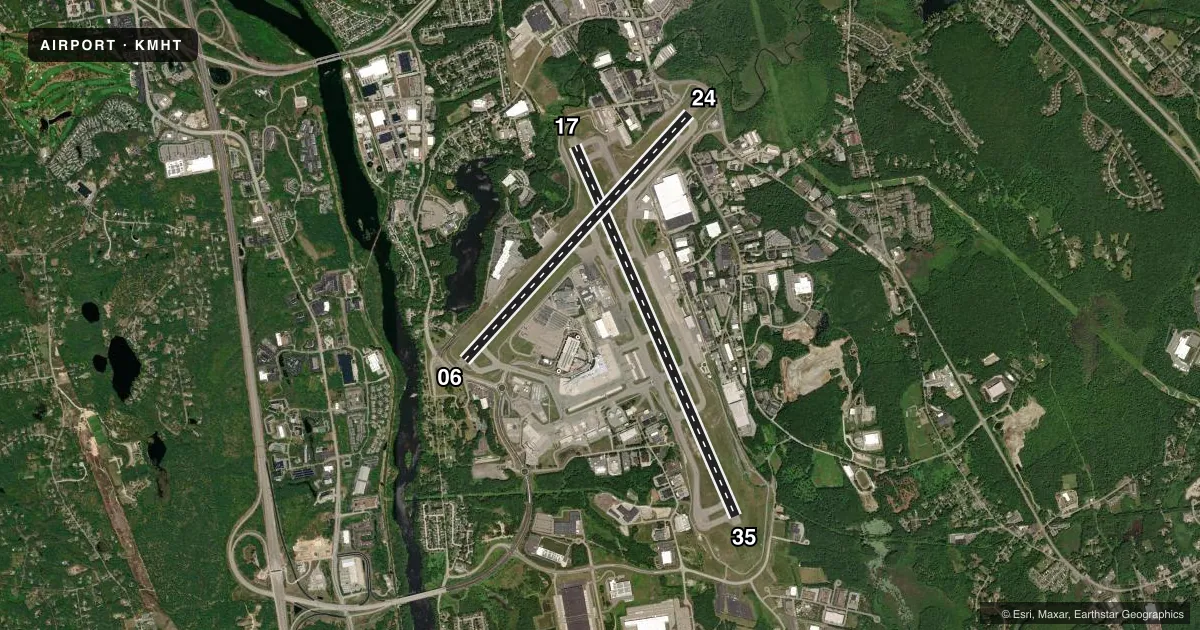
Runways & pattern
Full pagePattern entry · RWY 24
LEFT TRAFFIC| Runway | Heading (°M) | Length | Surface | Traffic |
|---|---|---|---|---|
| 17/35 | 142° / 322° | 9,250 ft | ASPH | Standard L |
| 06/24Favored | 27° / 207° | 7,651 ft | ASPH | Standard L |
Runway end performance
| End | TORA | TODA | ASDA | LDA | VGSI | Approach lights | Obstruction |
|---|---|---|---|---|---|---|---|
| 17 | 9,250' | 9,250' | 9,250' | 8,914' | PAPI 4-box right(3.1°) | MALSR | 71', pole, 2600' from thr, 125' R of cntrln, slope 34 |
| 35 | 9,250' | 9,250' | 8,500' | 7,650' | PAPI 4-box left(3°) | ALSF2 | 53', bldg, 3025' from thr, 75' R of cntrln, slope 50 |
| 06 | 7,650' | 7,650' | 7,650' | 7,208' | PAPI 4-box left(3°) | — | 61', trees, 2667' from thr, 470' R of cntrln, slope 40 |
| 24 | 7,650' | 7,650' | 6,850' | 6,850' | PAPI 4-box left(3°) | — | 52', trees, 1500' from thr, 75' R of cntrln, slope 25 |
Declared distances in feet. TORA = takeoff run available, TODA = takeoff distance, ASDA = accelerate-stop, LDA = landing distance.
Airport sketch
Runways drawn to scale from FAA survey coordinates, rendered over satellite imagery. Not for navigation.
Approaches & charts
ILS · 3
Services on the field
Fuel grades, oxygen, maintenance, ramp storage and lighting — as declared to the FAA by the airport operator.
Fuel & services
- Fuel
- 100LLA
- Oxygen (bottled)
- High pressure
- Oxygen (bulk)
- Not available
- Airframe repair
- Major
- Power plant repair
- Major
- Other services
- AFRT,AVNCS,CHTR,INSTR,RNTL
Ramp & ground
- Transient storage
- Tie-down
- Hangar
- Landing fee
- Yes
- Customs
- Not available
- Lighting schedule
- SS-SR
- Beacon schedule
- SS-SR
- Beacon
- White / Green (civil land)(WG)
- Wind indicator
- Lighted
- Segmented circle
- No
Fuel & FBOs
Cheapest 100LL and Jet A on the field and nearby. Always confirm with the FBO before taxi.
Airport notes
Surface conditions, obstructions, local procedures, lighting outages and other notes published with each FAA cycle.
General notes
- AIR CARRIERS EXCLUDED FM OPERATING ON TWY L.
- NO TGLS PERMITTED DURG SNOW REMOVAL OPNS.
- NOISE ABATEMENT PROCEDURES: TURBOJET ACFT SHOULD EXPECT A RIGHT TURN WHEN DEPARTING RY 17.
- ACFT NOT PERMITTED TO TAXI BETWEEN AIRLINE TERMINAL BLDG & ACFT THAT HAVE PUSHED BACK OR ARE TAXIING ON TWY G OR N.
- AIR CARRIER ACFT ONLY PERMITTED TO OPR ON AIRLINE TERMINAL RAMP.
- JET ACFT TAXIING WB ACRS RWY 17/35 AT TWY E MUST USE CTN & LOW SETTINGS DUE TO LGT ACFT PRKG ON E RAMP.
- NO TAXIING BTWN PUSHED BACK ACFT & THE AIRLINE TERMINAL OR CARGO RAMPS.
- TWY A SAFETY AREA S OF TWY E TO TWY A2 IS 65 FT.
- ACFT WITH WINGSPAN GREATER THAN 124 FT RSTRD FM TWY G AND TWY N.
- AMMON RAMP RSTRD TO ACFT WITH WINGSPAN LESS THAN 118 FT. ACFT ARE REQ TO MNTN TAXILANE CNTRLN TO AVOID PARKED GA ACFT TIEDOWNS. ACFT WITH WINGSPAN 118 FT OR GTR REQ GND CREW ASSISTANCE FOR TAXI & PRKG.
Runway surface & condition
- 06/24PCR VALUE: 700/F/C/X/T
- 17/35PCR VALUE: 700/F/C/X/T
Approach & departure obstructions
- 06PAPI UNUSBL BYD 6 DEGS R OF CNTRLN.
Arresting gear
- 06_EMASENGINEERED MATERIALS ARRESTING SYSTEM (EMAS) 300 FT IN LENGTH BY 170 FT IN WIDTH LCTD AT THE DER 06.
Other notes
- ESTAB PRIOR TO 1959. HEL ASP: VFR WX OPNS ONLY.
VFR map & nearby airports
VFR sectional. Tap any ICAO chip to open that airport.
Key facts · KMHT
Answer card- ICAO
- KMHT
- Name
- MANCHESTER BOSTON RGNL
- Location
- MANCHESTER, NEW HAMPSHIRE
- Elevation
- 266.4 ft MSL
- Traffic pattern altitude
- 1,266.4 ft MSL (1,000 AGL)
- Control tower
- Towered · 24
- Total runways
- 2
- Longest runway
- 17/35 · 9,250 ft
- Published ILS approaches
- 3
- Published frequencies
- 13
- Magnetic variation
- 15°
- Current flight rules
- VFR
- Current wind
- 220° at 3 kt
- Favored runway now
- RWY 24
Manchester Boston Rgnl is in Manchester, New Hampshire. Field elevation is 266.4 ft MSL. The airport has two asphalt runways. The longest is runway 17/35 at 9,250 ft. Runway 06/24 is 7,651 ft. The tower is open 24 hours. There are 3 ILS approaches available for runway ends 06, 17 and 35.
Pattern altitude is not published in the facts. Verify the current traffic pattern altitude before you go. This field sits under Boston Class C service. Expect normal ATC coordination on arrival and departure. Signature Aviation is on the field. It carries 100LL and Jet A. Call them at (603) 782-0151 for current ramp and service details.
A few published remarks matter here. Taxiing is restricted around the airline terminal and cargo ramps. Aircraft are not permitted to taxi between the terminal and aircraft that have pushed back or are on taxiway G or N. Runway 06 has an EMAS at the departure end. The PAPI on 06 is unusable beyond 6 degrees right of centerline. Large aircraft also face wingspan limits on some ramps and taxiways. If you are flying a first visit, review the current Chart Supplement and brief the taxi plan before engine start.