METAR & TAF KDEN
Current METAR
Observed 08:53Z
KDEN 280853Z 10004KT 10SM SCT120 OVC220 21/17 A3014 RMK AO2 SLP112 T02110167 51003
- Wind
- 100° @ 4 kt
- Visibility
- 10 SM
- Temp / Dew
- 21°C / 17°C
- Altimeter
- 30.14 inHg
- Clouds
- OVC
- Density alt
- 7,185 ft
- Ceiling
- 22,000 ft AGL
- Rules
- VFR
Airport info & contacts
Manager on record, flight service, ARTCC, attendance schedule and pattern altitude — published by the FAA and refreshed every 28 days.
Location
- From city
- 16 NM NE
- VFR sectional
- DENVER
- ARTCC
- ZDV · DENVER
- NOTAM facility
- DEN (NOTAM-D)
Airport manager
- Name
- PHIL WASHINGTON
- Phone
- (303) 342-2206
- Address
- ADMIN BLDG, 8500 PENA BLVD, DENVER CO 80249
Flight service · Hours
- FSS DEN
- DENVER1-800-WX-BRIEF
- Attendance
- ALL
Frequencies
Tap any row to copy the frequency to your clipboard.
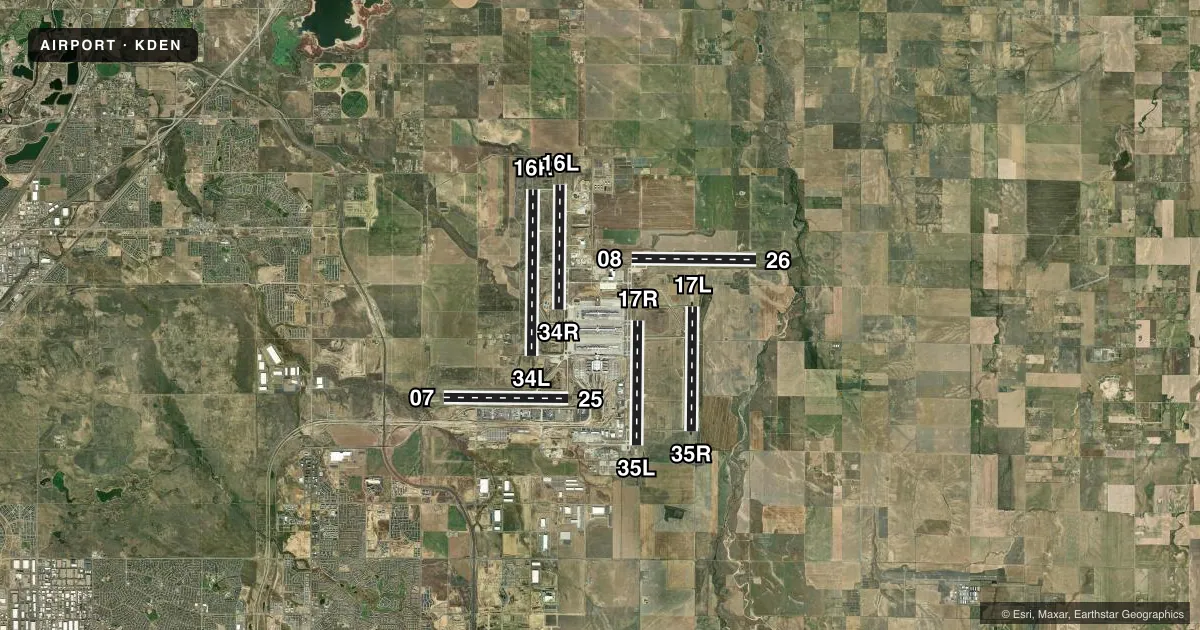
Runways & pattern
Full pagePattern entry · RWY 08
LEFT TRAFFIC| Runway | Heading (°M) | Length | Surface | Traffic |
|---|---|---|---|---|
| 16R/34L | 173° / 353° | 16,000 ft | CONC | Standard L |
| 16L/34R | 173° / 353° | 12,000 ft | CONC | Standard L |
| 08/26Favored | 83° / 263° | 12,000 ft | CONC | Standard L |
| 17L/35R | 173° / 353° | 12,000 ft | CONC | Standard L |
| 07/25 | 82° / 263° | 12,000 ft | CONC | Standard L |
| 17R/35L | 173° / 353° | 12,000 ft | CONC | Standard L |
Runway end performance
| End | TORA | TODA | ASDA | LDA | VGSI | Approach lights | Obstruction |
|---|---|---|---|---|---|---|---|
| 16R | 16,000' | 16,000' | 16,000' | 16,000' | PAPI 4-box right(3°) | MALSR | — |
| 34L | 16,000' | 16,000' | 16,000' | 16,000' | PAPI 4-box left(3°) | ALSF2 | — |
| 16L | 12,000' | 12,000' | 12,000' | 12,000' | PAPI 4-box left(3°) | MALSR | — |
| 34R | 12,000' | 13,000' | 12,000' | 12,000' | PAPI 4-box left(3°) | ALSF2 | — |
| 08 | 12,000' | 13,000' | 12,000' | 12,000' | PAPI 4-box left(3°) | MALSR | — |
| 26 | 12,000' | 12,000' | 12,000' | 12,000' | PAPI 4-box left(3°) | MALSR | — |
| 17L | 12,000' | 12,000' | 12,000' | 12,000' | PAPI 4-box left(3°) | MALSR | — |
| 35R | 12,000' | 12,000' | 12,000' | 12,000' | PAPI 4-box right(3°) | ALSF2 | — |
| 07 | 12,000' | 12,000' | 12,000' | 12,000' | PAPI 4-box right(3°) | MALSR | — |
| 25 | 12,000' | 13,000' | 12,000' | 12,000' | PAPI 4-box left(3°) | MALSR | 117', pole, 5100' from thr, 500' R of cntrln, slope 41 |
| 17R | 12,000' | 12,000' | 12,000' | 12,000' | PAPI 4-box left(3°) | MALSR | — |
| 35L | 12,000' | 12,000' | 12,000' | 12,000' | PAPI 4-box right(3°) | ALSF2 | — |
Declared distances in feet. TORA = takeoff run available, TODA = takeoff distance, ASDA = accelerate-stop, LDA = landing distance.
Airport sketch
Runways drawn to scale from FAA survey coordinates, rendered over satellite imagery. Not for navigation.
Approaches & charts
ILS · 12
Services on the field
Fuel grades, oxygen, maintenance, ramp storage and lighting — as declared to the FAA by the airport operator.
Fuel & services
- Fuel
- 100LLA
- Oxygen (bottled)
- High pressure
- Oxygen (bulk)
- High pressure
- Airframe repair
- Major
- Power plant repair
- Major
Ramp & ground
- Transient storage
- Hangar
- Landing fee
- Yes
- Customs
- Not available
- Lighting schedule
- SS-SR
- Beacon schedule
- SS-SR
- Beacon
- White / Green (civil land)(WG)
- Wind indicator
- Yes
- Segmented circle
- No
Fuel & FBOs
Cheapest 100LL and Jet A on the field and nearby. Always confirm with the FBO before taxi.
Airport notes
Surface conditions, obstructions, local procedures, lighting outages and other notes published with each FAA cycle.
General notes
- OVHD PAX BRIDGE S SIDE OF CONCOURSE-A PRVDS 42 FT TAIL & 118 FT WINGSPAN CLNC WHEN ON TWY CNTRLN.
- CUSTOMS AVBL PPR.
- INFORMAL RWY USE PROGRAM IN EFCT H24; NOISE ABATEMENT INFO - ARPT MGMT 303-342-4200.
- WATERFOWL & BIRDS INVOF ARPT.
- DEP RWY 08, 25 & 34R HAS MNTND CWY 500 X 1000 FT 1.25 SLOPE.
- TWY F7 CLSD TO ACFT WINGSPAN MORE THAN 118 FT.
Runway surface & condition
- 07/25PCR VALUE: 1050/R/B/W/T
- 08/26PCR VALUE: 1050/R/B/W/T
- 16L/34RPCR VALUE: 1050/R/B/W/T
- 16R/34LPCR VALUE: 1050/R/B/W/T
- 17L/35RPCR VALUE: 1050/R/B/W/T
- 17R/35LPCR VALUE: 1050/R/B/W/T
VFR map & nearby airports
VFR sectional. Tap any ICAO chip to open that airport.
Key facts · KDEN
Answer card- ICAO
- KDEN
- Name
- DENVER INTL
- Location
- DENVER, COLORADO
- Elevation
- 5,433.8 ft MSL
- Traffic pattern altitude
- 6,433.8 ft MSL (1,000 AGL)
- Control tower
- Towered · 24
- Total runways
- 6
- Longest runway
- 16R/34L · 16,000 ft
- Published ILS approaches
- 12
- Published frequencies
- 43
- Magnetic variation
- 8°
- Current flight rules
- VFR
- Current wind
- 100° at 4 kt
- Favored runway now
- RWY 08
Denver Intl sits in Denver, Colorado. Field elevation is 5,433.8 ft MSL. The airport has 6 runways. The longest is 16,000 ft on 16R/34L. The tower is open 24 hours. Twelve ILS approaches are published across the field, which gives you options on multiple runway ends.
Pattern altitude is not published. Use 1,000 ft AGL for light piston operations unless the current Chart Supplement or ATC gives you something different. This is a busy Class B airport. Expect heavy airline traffic. Expect fast taxi flows. Expect close attention to runway assignments. The airport also has an informal runway use program in effect all day. Noise abatement information is available from airport management. Check it before you go if you are planning a piston arrival or departure.
Signature Aviation is on the field. It carries 100LL and Jet A. The airport remarks also note birds and waterfowl in the area. Customs is available with prior permission required. Some departures use maintained clearways on runways 08, 25 and 34R. Taxiway F7 is closed to aircraft with wingspans greater than 118 ft. Denver’s elevation also means performance planning matters. Expect higher density altitude effects, especially on warm days.