METAR & TAF KSWF
Current METAR
Observed 11:45Z
KSWF 271145Z VRB04KT 10SM SCT110 21/17 A2984
- Wind
- VAR @ 4 kt
- Visibility
- 10 SM
- Temp / Dew
- 21°C / 17°C
- Altimeter
- 29.84 inHg
- Clouds
- SCT
- Density alt
- 1,428 ft
- Ceiling
- Unlimited
- Rules
- VFR
Airport info & contacts
Manager on record, flight service, ARTCC, attendance schedule and pattern altitude — published by the FAA and refreshed every 28 days.
Location
- From city
- 44 NM N
- VFR sectional
- NEW YORK
- Pattern altitude
- 709 ft AGL · 1,200 ft MSL
- ARTCC
- ZNY · NEW YORK
- NOTAM facility
- SWF (NOTAM-D)
Airport manager
- Name
- OMAR ASTACIO
- Phone
- 845-838-8200
- Address
- 1180 FIRST ST, NEW WINDSOR NY 12553
Flight service · Hours
- FSS ISP
- NEW YORK1-800-WX-BRIEF
- Attendance
- ALL
Frequencies
Tap any row to copy the frequency to your clipboard.
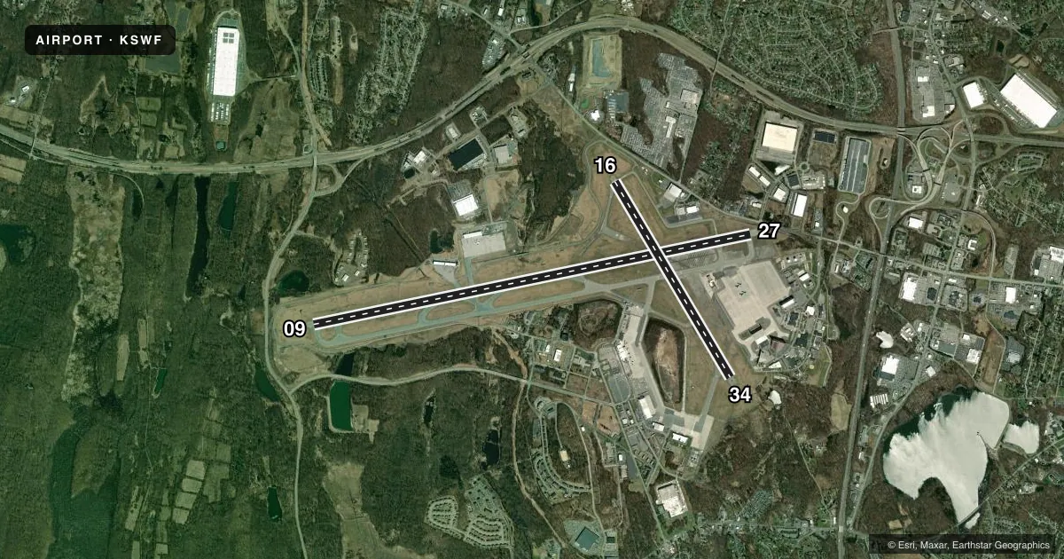
Runways & pattern
Full pagePattern entry · RWY 34
LEFT TRAFFIC| Runway | Heading (°M) | Length | Surface | Traffic |
|---|---|---|---|---|
| 09/27 | 64° / 244° | 11,817 ft | ASPH | Standard L |
| 16/34Favored | 135° / 315° | 6,004 ft | ASPH | Standard L |
Runway end performance
| End | TORA | TODA | ASDA | LDA | VGSI | Approach lights | Obstruction |
|---|---|---|---|---|---|---|---|
| 09 | 11,817' | 11,817' | 10,817' | 8,817' | PAPI 4-box left(3°) | ALSF2 | 38', fence, 420' from thr, 550' R of cntrln, slope 5 |
| 27 | 11,817' | 11,817' | 11,817' | 9,817' | PAPI 4-box left(3°) | — | 67', tree, 1120' from thr, 140' R of cntrln, slope 13 |
| 16 | 6,004' | 6,004' | 6,004' | 6,004' | PAPI 4-box left(3°) | — | — |
| 34 | 6,004' | 6,004' | 6,004' | 6,004' | PAPI 4-box left(3°) | — | 17', trees, 780' from thr, 220' R of cntrln, slope 34 |
Declared distances in feet. TORA = takeoff run available, TODA = takeoff distance, ASDA = accelerate-stop, LDA = landing distance.
Airport sketch
Runways drawn to scale from FAA survey coordinates, rendered over satellite imagery. Not for navigation.
Approaches & charts
ILS · 2
Services on the field
Fuel grades, oxygen, maintenance, ramp storage and lighting — as declared to the FAA by the airport operator.
Fuel & services
- Fuel
- 100LLA
- Oxygen (bottled)
- Not available
- Oxygen (bulk)
- Not available
- Airframe repair
- Major
- Power plant repair
- Major
- Other services
- CARGO,CHTR,INSTR,RNTL
Ramp & ground
- Transient storage
- Not published
- Landing fee
- No fee published
- Customs
- Not available
- Beacon schedule
- SS-SR
- Beacon
- White / Green (civil land)(WG)
- Wind indicator
- Lighted
- Segmented circle
- No
Fuel & FBOs
Cheapest 100LL and Jet A on the field and nearby. Always confirm with the FBO before taxi.
Airport notes
Surface conditions, obstructions, local procedures, lighting outages and other notes published with each FAA cycle.
General notes
- AVOID ORANGE COUNTY ARPT LCTD 7 NM WNW DURG VFR APCHS.
- BIRDS & DEER ON & INVOF ARPT.
- NO JET TRNG 2300 TO 0700 DLY.
- HUDSON VALLEY RGNL LCTD 3.3 NM SW IGN VORTAC; DO NOT MISTAKE FOR STEWART INTL.
- EXTSV GLDR ACT 8 MI E OF HUO VORTAC IN A 5-MI RADIUS.
- NOISE ABATEMENT PROCEDURES IN EFFECT CTC AMGR 845-838-8200.
- RGT TFC ON RWYS 16 & 27 MAY BE USED FOR NOISE ABATEMENT.
- USER FEE CHARGED TO ALL INTL FLIGHTS.
- COMPASS CALIBRATION PAD LCTD ON THE TWY G RUNUP APRON.
- TWYS B & H RESTRICTED TO ACFT WITH WINGSPAN GTR THAN 118 FT.
- TWY C RSTRD TO ACFT WITH WINGSPAN GTR THAN 125 FT BTN TRML BLDG & BLDG 118.
- ACFT WITH WINGSPAN 172 FT OR MORE RQR VEHICLE ESCORT FOR ALL TWY C OPNS S OF TRML APN. CTC ARPT OPNS 845-838-8237.
- MILITARY: ARMY OPS 1300-2100Z++ WEEKDAYS EXC HOL, O845-567-1209, OT CTC FBO. 24 HR PPR ONLY FOR PARKING ARMY RAMP. NO SVC AVAIL THROUGH ARMY RAMP, CTC FBO. 48 HR PPR ALL OPERATIONS ON WEST POINT MILITARY RESERVATION, CTC 2ND AVN DET OPSO, O845-567-1209, C845-372-3349.
- MILITARY: ALL MIL ACFT OPR, BASH PHASE II PERIOD (1 APR-30 MAY & 1 AUG-30 NOV) BIRD WATCH COND SEVERE (TKOF AND LDGS PROH UNLESS GREATER EMERG AND/OR IMMED OPERATIONAL NECESSITY EXISTS. LCL AND TACTICAL TRNG PROH) MODERATE (MULTIPLE APCHS PROH A DEPARTURE AND FULL STOP ALLOWED IF RTE AVOIDS BIRDS ACT.)
- MILITARY: AFLD MGR DOES NOT ISSUE OR STORE COMSEC FOR TRAN CREWS. TMPRY STOR OF CLASSIFIED MATERIALS UP TO SECRET AT COMD POST.
- TWY C BTN TWY B & TWY F NOT VISIBLE FM TWR.
- TWY L CLSD EXC 20 MIN PPR. TWY L APRON FOLLOW ME VEHICLE REQUIRED. CTC ARPT OPNS 845-838-8237.
- FUEL: A++ AVBL.
- MILITARY: ADVSY FOR TRAN AIRCREW - NSTD WHITE VEH PARKING BOXES AND C-17 WING-TIP GUIDE LINES PAINTED ON ANG RAMP.
- MILITARY: COMD POST OPR 1000-0400++, DSN 636-2286.
- ALL SFCS. WORK IN PROGRESS GRASS CUTTING CONDUCTED APR-OCT.
- TXL C NOT VSB TO TWR FOR ACFT PUSHBACK FM PAX TRML; CTC GND FREQ FOR PUSHBACK ONTO TXL C.
Runway surface & condition
- 09/27PCR VALUE: 733/F/B/X/T
- 16/34PCR VALUE: 733/F/B/X/T
- H1HELIPAD LCTD INTXN TWYS B & C EAST OF TWY C.
Approach & departure obstructions
- 09ALSF-2 SFL U/S.
- 16+3 FT GND 140 FT FM RWY END 240 FT L.
- 16MILITARY ASSAULT LANDING ZONE & BASIC MKGS WITH AIMING POINTS.
- 34MILITARY ASSAULT LANDING ZONE & BASIC MKGS WITH AIMING POINTS.
- 16PAPI UNUSBL BYD 5 DEGS LEFT OF CNTRLN.
- 09APCH SLP 50:1 TO DTHR.
- 27APCH SLP 46:1 TO DTHR.
Other notes
- LNDG FEE PER 1000 LBS. CERTIFICATED MAX TOG.
- TPA: 709 FT AGL HEL, 1009 FT AGL RECIPROCATING ENG, 2009 FT AGL TURBOPROP/JET.
- OWNERLEASEE PANYNJ; . PROPERTY OWNED BY NYSDOT 1220 WASHINGTON AVE. ALBANY, NY 12226. TELEPHONE 518-457-2822.
VFR map & nearby airports
VFR sectional. Tap any ICAO chip to open that airport.
Key facts · KSWF
Answer card- ICAO
- KSWF
- Name
- NEW YORK STEWART INTL
- Location
- NEW YORK, NEW YORK
- Elevation
- 490.7 ft MSL
- Traffic pattern altitude
- 1,199.7 ft MSL (709 AGL)
- Control tower
- Towered · 24
- Total runways
- 2
- Longest runway
- 09/27 · 11,817 ft
- Published ILS approaches
- 2
- Published frequencies
- 10
- Magnetic variation
- 14°
- Current flight rules
- VFR
- Current wind
- 000° at 4 kt
- Favored runway now
- RWY 34
New York Stewart Intl sits in New York, New York. Field elevation is 490.7 ft MSL. The airport has 2 asphalt runways. The longest is 11,817 ft on 09/27. Tower is open 24 hours. Two ILS approaches are published for runway ends 09 and 27. Pattern altitude is 709 ft AGL. That is 1,199.7 ft MSL.
For fuel and ramp support, Atlantic Aviation is on the field with JET_A. Signature Aviation is also on the field with AVGAS_100LL and JET_A. If you need current handling details, call the FBO directly before arrival. Published remarks also flag birds and deer in the area. That matters here. There is also a note to avoid confusing this field with Orange County Airport 7 NM west-northwest during VFR approaches.
This is a controlled airport with busy mixed traffic. Runway 16 is marked as a military assault landing zone. Taxiway C has restrictions and some pushback work is not visible from the tower. If you are planning a larger aircraft operation, check the current Chart Supplement and coordinate early with airport ops. Military activity also occurs on weekdays during published Zulu hours. For anything that affects your arrival, verify with the airport operator or the FBO directly by phone.