METAR & TAF KHSV
Current METAR
Observed 13:21Z
KHSV 271321Z 23003KT 10SM FEW005 SCT130 OVC220 23/23 A2996 RMK AO2 T02330228 $
- Wind
- 230° @ 3 kt
- Visibility
- 10 SM
- Temp / Dew
- 23°C / 23°C
- Altimeter
- 29.96 inHg
- Clouds
- OVC
- Density alt
- 1,690 ft
- Ceiling
- 22,000 ft AGL
- Rules
- VFR
Airport info & contacts
Manager on record, flight service, ARTCC, attendance schedule and pattern altitude — published by the FAA and refreshed every 28 days.
Location
- From city
- 9 NM SW
- VFR sectional
- ATLANTA
- ARTCC
- ZME · MEMPHIS
- NOTAM facility
- HSV (NOTAM-D)
Airport manager
- Name
- BUTCH ROBERTS
- Phone
- 256-258-1958
- Address
- 1000 GLENN HEARN BLVD,, BOX 20008, HUNTSVILLE AL 35824
Flight service · Hours
- FSS ANB
- ANNISTON1-800-WX-BRIEF
- Attendance
- ALL
Frequencies
Tap any row to copy the frequency to your clipboard.
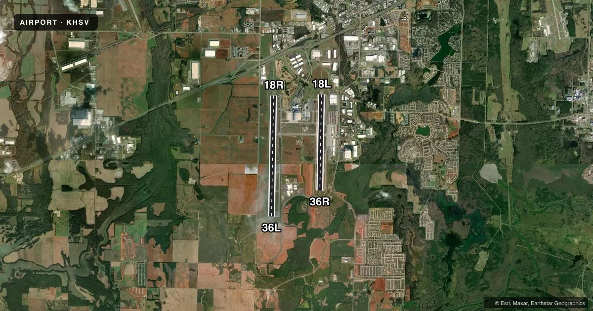
Runways & pattern
Full pagePattern entry · RWY 18R
RIGHT TRAFFIC| Runway | Heading (°M) | Length | Surface | Traffic |
|---|---|---|---|---|
| 18R/36LFavored | 177° / 357° | 12,600 ft | ASPH-CONC | 18R R |
| 18L/36R | 177° / 357° | 10,001 ft | ASPH | 36R R |
Runway end performance
| End | TORA | TODA | ASDA | LDA | VGSI | Approach lights | Obstruction |
|---|---|---|---|---|---|---|---|
| 18R | 12,600' | 12,600' | 12,600' | 12,600' | — | ALSF2 | — |
| 36L | 12,600' | 12,600' | 12,600' | 12,600' | — | MALSR | — |
| 18L | 10,001' | 10,001' | 9,801' | 9,801' | PAPI 4-box right(3°) | MALSR | — |
| 36R | 10,001' | 10,001' | 10,001' | 9,801' | PAPI 4-box right(3°) | MALSR | — |
Declared distances in feet. TORA = takeoff run available, TODA = takeoff distance, ASDA = accelerate-stop, LDA = landing distance.
Airport sketch
Runways drawn to scale from FAA survey coordinates, rendered over satellite imagery. Not for navigation.
Approaches & charts
ILS · 4
Services on the field
Fuel grades, oxygen, maintenance, ramp storage and lighting — as declared to the FAA by the airport operator.
Fuel & services
- Fuel
- 100LLA
- Oxygen (bottled)
- HIGH/LOW
- Oxygen (bulk)
- HIGH/LOW
- Airframe repair
- Major
- Power plant repair
- Major
- Other services
- AFRT,AVNCS,CARGO,CHTR,INSTR,RNTL,SURV
Ramp & ground
- Transient storage
- Tie-down
- Hangar
- Landing fee
- No fee published
- Customs
- Not available
- Lighting schedule
- SEE RMK
- Beacon schedule
- SS-SR
- Beacon
- White / Green (civil land)(WG)
- Wind indicator
- Lighted
- Segmented circle
- Yes
Fuel & FBOs
Cheapest 100LL and Jet A on the field and nearby. Always confirm with the FBO before taxi.
Airport notes
Surface conditions, obstructions, local procedures, lighting outages and other notes published with each FAA cycle.
General notes
- INTXN OF TWY J AND SERVICE RD IS UNCONTROLLED.
- LINE UP AND WAIT NA.
- FOR CD WHEN TWR CLSD, IF UNA TO CTC ON FSS FREQ, CTC MEMPHIS ARTCC AT 901-368-8453/8449.
- FLT NOTIFICATION SVC (ADCUS) AVBL.
Lighting notes
- ACTVT MALSR RWY 18L, 36L & 36R; HIRL RWY 18L/36R & 18R/36L - CTAF. RWY 18R ALSF ON STEP 2 WHEN ATCT CLSD.
Runway surface & condition
- 18L/36RPCR VALUE: 620/F/B/X/T
- 18R/36LPCR VALUE: 768/F/B/X/T
Approach & departure obstructions
- 36ROBSTN CLNC SLOPE 50:1 AT DSPLCD THR.
Other notes
- CTC HSV ARFF ON CTAF OR PHONE 256-461-1115 FOR EMERG WHEN ATCT CLSD.
- OWNERAIRPORT AUTHORITY
VFR map & nearby airports
VFR sectional. Tap any ICAO chip to open that airport.
Key facts · KHSV
Answer card- ICAO
- KHSV
- Name
- HUNTSVILLE INTL-CARL T JONES FLD
- Location
- HUNTSVILLE, ALABAMA
- Elevation
- 628.9 ft MSL
- Traffic pattern altitude
- 1,628.9 ft MSL (1,000 AGL)
- Control tower
- Towered · 0600-0000
- Total runways
- 2
- Longest runway
- 18R/36L · 12,600 ft
- Published ILS approaches
- 4
- Published frequencies
- 19
- Magnetic variation
- 4°
- Current flight rules
- VFR
- Current wind
- 230° at 3 kt
- Favored runway now
- RWY 18R
Huntsville Intl-Carl T Jones Fld (KHSV) sits in Huntsville, Alabama. Field elevation is 628.9 ft MSL. The airport has two asphalt runways. The longest is 18R/36L at 12,600 ft. The other runway is 18L/36R at 10,001 ft. The tower is open daily from 0600 to 0000.
KHSV has four ILS approach options. They serve 18L, 18R, 36L and 36R. Pattern altitude is not published in the facts, so use the standard 1,000 ft AGL for light piston traffic unless the current Chart Supplement says otherwise. Signature Aviation is on the field. It carries 100LL and Jet A. Call them at (256) 772-9341 for current ramp and fuel details.
This is a busy controlled field with Class C service on the published frequencies. Expect to work the tower and ground closely. The published remarks also note that line up and wait is not authorized. When the tower is closed, emergency contact is Huntsville Aircraft Rescue and Fire Fighting on CTAF or by phone. Runway lighting is strong here. MALSR is available for 18L, 36L and 36R. High intensity runway lighting is available for both runway pairs on CTAF. If you are new to the airport, review the current Chart Supplement before departure for any operational notes. Pay attention to the displaced threshold and obstacle clearance note on 36R.