METAR & TAF KMHR
Current METAR
Observed 15:15Z
KMHR 271515Z AUTO 19007KT 10SM CLR 19/11 A2997 RMK AO2 T01940114 $
- Wind
- 190° @ 7 kt
- Visibility
- 10 SM
- Temp / Dew
- 19°C / 11°C
- Altimeter
- 29.97 inHg
- Clouds
- CLR
- Density alt
- 540 ft
- Ceiling
- Unlimited
- Rules
- VFR
Airport info & contacts
Manager on record, flight service, ARTCC, attendance schedule and pattern altitude — published by the FAA and refreshed every 28 days.
Location
- From city
- 10 NM E
- VFR sectional
- SAN FRANCISCO
- ARTCC
- ZOA · OAKLAND
- NOTAM facility
- MHR (NOTAM-D)
Airport manager
- Name
- RON OGLE
- Phone
- 916-875-7077
- Address
- 10425 NORDEN AVE, MATHER CA 95655
Flight service · Hours
- FSS RIU
- RANCHO MURIETA1-800-WX-BRIEF
- Attendance
- 0500-2200
Frequencies
Tap any row to copy the frequency to your clipboard.
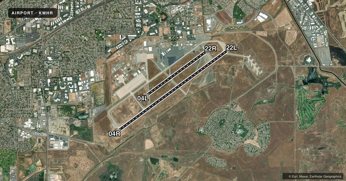
Runways & pattern
Full pagePattern entry · RWY 22L
LEFT TRAFFIC| Runway | Heading (°M) | Length | Surface | Traffic |
|---|---|---|---|---|
| 04R/22LFavored | 41° / 221° | 11,301 ft | ASPH-CONC | 04R R |
| 04L/22R | 41° / 221° | 6,081 ft | ASPH | 22R R |
Runway end performance
| End | TORA | TODA | ASDA | LDA | VGSI | Approach lights | Obstruction |
|---|---|---|---|---|---|---|---|
| 04R | — | — | — | — | VASI 4-box left(3°) | — | — |
| 22L | — | — | — | — | VASI 4-box left(3°) | MALSR | — |
Declared distances in feet. TORA = takeoff run available, TODA = takeoff distance, ASDA = accelerate-stop, LDA = landing distance.
Airport sketch
Runways drawn to scale from FAA survey coordinates, rendered over satellite imagery. Not for navigation.
Approaches & charts
ILS · 1
Services on the field
Fuel grades, oxygen, maintenance, ramp storage and lighting — as declared to the FAA by the airport operator.
Fuel & services
- Fuel
- 100LLA
- Oxygen (bulk)
- Low pressure
- Airframe repair
- Major
- Power plant repair
- Major
- Other services
- AFRT,CARGO
Ramp & ground
- Transient storage
- Tie-down
- Hangar
- Landing fee
- No fee published
- Customs
- Not available
- Lighting schedule
- SEE RMK
- Beacon schedule
- SS-SR
- Beacon
- White / Green (civil land)(WG)
- Wind indicator
- Lighted
- Segmented circle
- No
Fuel & FBOs
Cheapest 100LL and Jet A on the field and nearby. Always confirm with the FBO before taxi.
Airport notes
Surface conditions, obstructions, local procedures, lighting outages and other notes published with each FAA cycle.
General notes
- RY 22L CALM WIND RY.
- BE ALERT FOR LARGE TRANSPORT ACFT TKOFS & LNDGS AND HIGH PERFORMANCE MILITARY T-38 JETS.
- AVOID NOISE SENSITIVE RESIDENTIAL AREAS NORTH/EAST OF RY 22L ILS FINAL APCH COURSE. TURBOJET NIGHTTIME NOISE ABATEMENT ARRIVAL AND DEPARTURE PROCEDURES IN EFFECT 2200-0700 DAILY.
- PILOT INFORMATION ON NOISE ABATEMENT (916) 874-0359.
- BIRDS INVOF OF ARPT.
- ACFT ENTERING RY 22R TFC PAT FM THE NORTH SHOULD EXPECT TO FLY BASE LEG EXTENDED 2 MILES FM RY THLD.
- FOR CD WHEN ATCT IS CLSD CTC NORCAL APCH AT 916-361-6874.
- TWY D1 CLSD TO ACFT WITH WINGSPAN MORE THAN 69 FT.
- NO FLD COND NOTAMS AVBL 1600-0600.
Lighting notes
- WHEN ATCT CLSD ACTVT HIRL RWY 04R/22L; VASI RWY 04R & 22L; MALSR RWY 22L - CTAF.
Runway surface & condition
- 04R/22LSWL 65/PSI 640.
- 04L/22RRWY 04L/22R MIRL DECOMISSIONED.
Other notes
- NO OBJECTION
- TPA FOR PISTON ACFT 1000 FT AGL; TURBINE ACFT 1800 FT AGL.
VFR map & nearby airports
VFR sectional. Tap any ICAO chip to open that airport.
Key facts · KMHR
Answer card- ICAO
- KMHR
- Name
- SACRAMENTO MATHER
- Location
- SACRAMENTO, CALIFORNIA
- Elevation
- 98.3 ft MSL
- Traffic pattern altitude
- 1,098.3 ft MSL (1,000 AGL)
- Control tower
- Towered · 0500-2100
- Total runways
- 2
- Longest runway
- 04R/22L · 11,301 ft
- Published ILS approaches
- 1
- Published frequencies
- 12
- Magnetic variation
- 13°
- Current flight rules
- VFR
- Current wind
- 190° at 7 kt
- Favored runway now
- RWY 22L
Sacramento Mather Airport sits in Sacramento, California. Field elevation is 98.3 ft MSL. The airport has two runways. The longest is 11,301 ft on 04R/22L. The other runway is 6,081 ft on 04L/22R. The control tower is open daily from 0500 to 2100.
There is one ILS approach. It serves runway 22L. Pattern altitude for piston aircraft is 1,000 ft AGL. That puts the published piston pattern at 1,098.3 ft MSL. Turbine traffic uses 1,800 ft AGL.
On the field, Mather Jet Center carries 100LL, Jet A and Jet A Prist. Modern Aviation also carries 100LL, Jet A and Jet A Prist. For a first-time arrival, pay attention to the noise-sensitive neighborhoods north and east of the 22L final. Turbojet nighttime noise abatement procedures are in effect from 2200 to 0700. Be alert for large transport traffic and high-performance military T-38 jets. When the tower is closed, clearance delivery goes through NorCal Approach. Runway 04L/22R has decommissioned medium intensity runway lighting. Plan your night work around 04R/22L if you need lighting.