METAR & TAF KMCC
Current METAR
Observed 13:30Z
KMCC 271330Z AUTO 16007KT 10SM CLR 16/12 A2996 RMK AO2
- Wind
- 160° @ 7 kt
- Visibility
- 10 SM
- Temp / Dew
- 16°C / 12°C
- Altimeter
- 29.96 inHg
- Clouds
- CLR
- Density alt
- 166 ft
- Ceiling
- Unlimited
- Rules
- VFR
Airport info & contacts
Manager on record, flight service, ARTCC, attendance schedule and pattern altitude — published by the FAA and refreshed every 28 days.
Location
- From city
- 6 NM NE
- VFR sectional
- SAN FRANCISCO
- Pattern altitude
- 1,076 ft AGL · 1,153 ft MSL
- ARTCC
- ZOA · OAKLAND
- NOTAM facility
- MCC (NOTAM-D)
Airport manager
- Name
- JOSHUA HENRY
- Phone
- 916-570-5317
- Address
- 3028 PEACEKEEPER WAY, MCCLELLAN CA 95652-2502
Flight service · Hours
- FSS RIU
- RANCHO MURIETA1-800-WX-BRIEF
- Attendance
- ALL
Frequencies
Tap any row to copy the frequency to your clipboard.
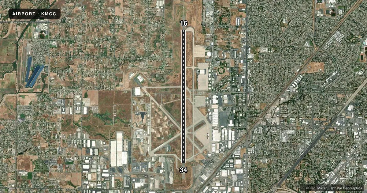
Runways & pattern
Full pagePattern entry · RWY 16
RIGHT TRAFFICRunway end performance
| End | TORA | TODA | ASDA | LDA | VGSI | Approach lights | Obstruction |
|---|---|---|---|---|---|---|---|
| 16 | — | — | — | — | PAPI 4-box left(3°) | MALSR | — |
| 34 | — | — | — | — | PAPI 4-box left(3°) | — | 90', tower, 4000' from thr, 175' R of cntrln, slope 42 |
Declared distances in feet. TORA = takeoff run available, TODA = takeoff distance, ASDA = accelerate-stop, LDA = landing distance.
Airport sketch
Runways drawn to scale from FAA survey coordinates, rendered over satellite imagery. Not for navigation.
Approaches & charts
ILS · 2
Services on the field
Fuel grades, oxygen, maintenance, ramp storage and lighting — as declared to the FAA by the airport operator.
Fuel & services
- Fuel
- 100LLAA+
- Oxygen (bottled)
- Not available
- Oxygen (bulk)
- HIGH/LOW
- Airframe repair
- Major
- Power plant repair
- Major
- Other services
- AFRT,AMB,AVNCS,CARGO,CHTR,SALES
Ramp & ground
- Transient storage
- Tie-down
- Hangar
- Landing fee
- No fee published
- Customs
- Not available
- Lighting schedule
- SEE RMK
- Beacon schedule
- SS-SR
- Beacon
- White / Green (civil land)(WG)
- Wind indicator
- Yes
- Segmented circle
- Yes
Fuel & FBOs
Cheapest 100LL and Jet A on the field and nearby. Always confirm with the FBO before taxi.
Airport notes
Surface conditions, obstructions, local procedures, lighting outages and other notes published with each FAA cycle.
General notes
- 900 FT ASPH OVRN SE END RY 16 & 1000 FT ASPH OVRN NW END RY 34.
- FLD CONDS-RWY, TWY & APRON GOOD.
- STRICT ADHERENCE TO PUBLD TFC PATS RCMD FOR NS ABTMT PURPOSES.
- TOUCH/GO LNDG FOR C5 PROHIBITED.
- DURG INCREASED BIRD CONDITIONS THE POTENTIAL FOR BIRD CONGESTION EXIST AT BOTH ARR/DEP ENDS RY 16/34.
- ALL ACFT EXIT RY TO THE EAST. SELF SRV 100LL W SIDE TW KILO.
- MILITARY USE: FUEL - A+ (MCCLELLAN JET SVC, C916-641-8970.)
- MILITARY USE: TRAN ACFT PPR FOR USCG RAMP C916-643-7659, WITH CREW LIST FOR ARR/DEP PAX.
- RY 16 CALM WIND RWY.
- TWYS E,F,G NSTD TWY EDGE LGTG.
- FOR CD CTC NORCAL APCH AT 916-361-6874.
Lighting notes
- ACTVT MALSR RWY 16; HIRL RWY 16/34; TWY LGTS - CTAF. PAPI RWYS 16 & 34 OPR CONSLY.
Fuel notes
- 100LLSELF-SERVICE 100LL FUEL WEST SIDE TWY KILO.
Runway surface & condition
- 16/34NSTD HIRL LCTD 25 FT FM RY EDGE MARKINGS.
Approach & departure obstructions
- H1MILITARY MARKINGS ON AIRFIELD.
Other notes
- MANAGEREMAIL: JHENRY@FLYKMCC.COM
VFR map & nearby airports
VFR sectional. Tap any ICAO chip to open that airport.
Key facts · KMCC
Answer card- ICAO
- KMCC
- Name
- MC CLELLAN AIRFIELD
- Location
- SACRAMENTO, CALIFORNIA
- Elevation
- 76.8 ft MSL
- Traffic pattern altitude
- 1,152.8 ft MSL (1,076 AGL)
- Control tower
- Non-towered (use CTAF)
- Total runways
- 1
- Longest runway
- 16/34 · 10,599 ft
- Published ILS approaches
- 2
- Published frequencies
- 5
- Magnetic variation
- 17°
- Current flight rules
- VFR
- Current wind
- 160° at 7 kt
- Favored runway now
- RWY 16
McClellan Airfield sits in Sacramento, California. Field elevation is 76.8 ft MSL. The airport has one runway, 16/34, at 10,599 ft. It is a no-tower field. Pattern altitude is 1,076 ft AGL, which is 1,152.8 ft MSL.
Runway 16 has the calm wind preference in the published remarks. Two ILS approaches are available. One serves runway 16. One serves runway 34. The field also has MALSR on runway 16. High intensity runway lights are on both runway ends. Taxiway lights are controlled by CTAF. PAPI runs continuously on 16 and 34.
McClellan Jet Services is on the field. It carries AVGAS 100LL, JET A and JET A PRIST. Self-serve 100LL is also available on the west side of taxiway Kilo. First-time pilots should pay attention to the runway exit instructions. All aircraft exit the runway to the east. Watch for bird activity near both ends of runway 16/34 during increased bird conditions. Taxiways E, F and G have nonstandard edge lighting. Clearance delivery is handled by NorCal Approach. Check the current FAA Chart Supplement or call the airport operator if you need the latest local procedures before arrival.